Mountain hikes Raitiser Almweg (512)

Mutters / Stubai Alps
Difficulty ratings: medium
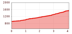
Route length: 8.2 km
Duration: 2:30 h

Raitiser Almweg (512)

Tour information

  • Requirement: medium
  • Length: 8.2 km
  • Duration: 2:30 h
  • Elevation uphill:640 hm
  • Elevation downhill:640 hm
Highest point1,547 m

Starting point

Mutters/Raitis

Finishing point

Raitiser Alm

Best time of year

  • January
  • February
  • March
  • April
  • May
  • June
  • July
  • August
  • September
  • October
  • November
  • December

Trail condition

Forest path
Source: Innsbruck Tourismus

Description

Before reaching the Gasthof Scheipenhof, the trail leaves the forest and continues across meadows, offering beautiful views of the Stubai Valley and the surrounding mountains. The final section of the trail goes through the forest again, leading to the Raitiser Alm. From there, good connections lead to the Kreither Alm and the Mutterer Alm, which can be reached via an easy panorama path offering stunning views of the valley and mountains.
To get back to the starting point, hike back along the same route.

Please note: The Raitiser Alm is not serviced, so it's recommended to bring enough provisions.

Nearby huts and mountain restaurants

Getting here

  • Arrival by public transport

    Take the Stubaitalbahn STB to the Raitis stop.

Weather

Today

light rain
15°C/10°C
80%5.3l5 km/h

Fri

cloudy
18°C/9°C
50%0l5 km/h

Sat

clear sky
22°C/7°C
0%0l5 km/h
Go to weather forecast

More tours in the surrounding area

Newsletter

The mountain is calling? So does our newsletter!

In our monthly newsletter we reveal the best holiday tips for Tyrol.