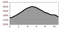
Open interactive mapOpen this POI on the interactive mapElevation profileSchnadiger Weiher (Kaunerberg).gpx
Gallruth Stollenwanderung_Daniel Zangerl.jpg © Daniel Zangerl Kaunerberger WasserwegDifficulty:mediumLength:15.2 kmDuration:6:00 hElevation uphill:935 mSee trailSee trail: Kaunerberger Wasserweg
©-TVB-Tiroler-Oberland-Kaunertal-Daniel-Zangerl-Aifneralm-2016-(19).jpg © Daniel Zangerl Rolli-Wanderung Aifner AlmDifficulty:mediumLength:6.0 kmDuration:2:30 hElevation uphill:460 mSee trailSee trail: Rolli-Wanderung Aifner Alm
©-TVB-Tiroler-Oberland-Rudi-Wyhlidal-Aifnerspitze-Wanderführerin (124).jpg © Rudi Wyhlidal Hohe Aifnerspitze (2.779 m)Difficulty:mediumLength:7.2 kmDuration:5:15 hElevation uphill:815 mSee trailSee trail: Hohe Aifnerspitze (2.779 m)
Panoramaweg Aifner Alm - Falkauns AlmDifficulty:mediumLength:6.2 kmDuration:2:40 hElevation uphill:300 mSee trailSee trail: Panoramaweg Aifner Alm - Falkauns Alm
Sonnenuntergang Wandern Herbst Möslalm Wörgl 2022@Region Hohe Salve - Mathäus Gartner (21).jpg © Mathäus Gartner Möslalmkogel via WörglDifficulty:mediumLength:10.3 kmDuration:3:30 hElevation uphill:580 mSee trailSee trail: Möslalmkogel via Wörgl
Adlerweg Day TourDifficulty:mediumLength:16.0 kmDuration:8:30 hElevation uphill:1,200 mSee trailSee trail: Adlerweg Day Tour
Hundalmjoch © Ferienregion Hohe Salve Hike to the HundalmjochDifficulty:mediumDuration:7:00 hElevation uphill:993 mSee trailSee trail: Hike to the Hundalmjoch
Eagle trail stage 5 © Tirol Werbung/Jens Schwarz Eagle Walk Stage 05: Gasthof Buchacker - PineggDifficulty:difficultLength:18.0 kmDuration:6:00 hElevation uphill:980 mSee trailSee trail: Eagle Walk Stage 05: Gasthof Buchacker - Pinegg
Give feedback for a chance to win a special holiday experience!Click here for the surveyClick here for the survey

.jpg")
.jpg")

.jpg")
.jpg")


