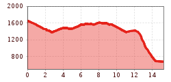
Open interactive mapOpen this POI on the interactive mapElevation profileSteinplatte Waidring - Durchkaseralm - Straubinger Haus - Erpfendorf.gpx
Kühtai - SulzkogelDifficulty: medium Length: 12.7 km Duration: 7:21 h Elevation uphill: 1,079 m See trailSee trail: Kühtai - Sulzkogel
3-hut hikeDifficulty: medium Length: 13.2 km Duration: 6:00 h Elevation uphill: 1,120 m See trailSee trail: 3-hut hike
Faltegartenköpfl peakDifficulty: medium Length: 8.5 km Duration: 4:30 h Elevation uphill: 509 m See trailSee trail: Faltegartenköpfl peak
Muhs panorama trailDifficulty: medium Length: 15.2 km Duration: 6:00 h Elevation uphill: 1,090 m See trailSee trail: Muhs panorama trail
Hike via Nördlinger Hütte to Reither SpitzeDifficulty: difficult Length: 9.9 km Duration: 7:30 h Elevation uphill: 1,191 m See trailSee trail: Hike via Nördlinger Hütte to Reither Spitze
Nauders mountain trailDifficulty: medium Length: 18.0 km Duration: 7:00 h Elevation uphill: 407 m See trailSee trail: Nauders mountain trail
The sunny plateau circuitDifficulty: easy Length: 33.0 km Duration: 8:00 h Elevation uphill: 740 m See trailSee trail: The sunny plateau circuit
Zams - Württemberger HausDifficulty: medium Length: 10.1 km Duration: 11:20 h Elevation uphill: 1,554 m See trailSee trail: Zams - Württemberger Haus
St. Sigmund - Pforzheimer Hütte mountain hut (145)Difficulty: medium Length: 14.1 km Duration: 5:00 h Elevation uphill: 781 m See trailSee trail: St. Sigmund - Pforzheimer Hütte mountain hut (145)
Along the Goetheweg trail to thePfeishütte mountain hutDifficulty: difficult Length: 5.2 km Duration: 5:00 h Elevation uphill: 344 m See trailSee trail: Along the Goetheweg trail to thePfeishütte mountain hut
At the foot of Fleischbank and TotenkirchlDifficulty: easy Length: 9.3 km Duration: 3:00 h Elevation uphill: 250 m See trailSee trail: At the foot of Fleischbank and Totenkirchl
Suspension bridge to Maria Locherboden pilgrimage churchDifficulty: medium Length: 8.5 km Duration: 3:00 h Elevation uphill: 370 m See trailSee trail: Suspension bridge to Maria Locherboden pilgrimage church
The Zirbenweg trailDifficulty: easy Length: 7.0 km Duration: 2:30 h Elevation uphill: 200 m See trailSee trail: The Zirbenweg trail
Carnic altitude trail. Stage 2: Sillianer Hütte- Obstansersee HütteDifficulty: medium Length: 8.7 km Elevation uphill: 503 m See trailSee trail: Carnic altitude trail. Stage 2: Sillianer Hütte- Obstansersee Hütte
Mountain station Spieljochbahn - Hochfügen Difficulty: medium Length: 12.2 km Duration: 4:00 h Elevation uphill: 270 m See trailSee trail: Mountain station Spieljochbahn - Hochfügen
Winter hiking Fieberbrunn - Zillstatt - StreubödenDifficulty: medium Length: 13.0 km Duration: 4:30 h Elevation uphill: 550 m See trailSee trail: Winter hiking Fieberbrunn - Zillstatt - Streuböden
Around the Thierbach HilltopDifficulty: medium Length: 5.5 km Duration: 2:00 h Elevation uphill: 162 m See trailSee trail: Around the Thierbach Hilltop
Schwarzer and Grüner SeeDifficulty: easy Length: 8.3 km Duration: 4:30 h Elevation uphill: 368 m See trailSee trail: Schwarzer and Grüner See
Hanauer HütteDifficulty: medium Length: 10.0 km Duration: 3:30 h Elevation uphill: 595 m See trailSee trail: Hanauer Hütte
High and sacred – Stage 03 from Maria Luggau to St. OswaldDifficulty: medium Length: 25.8 km Duration: 7:00 h Elevation uphill: 1,206 m See trailSee trail: High and sacred – Stage 03 from Maria Luggau to St. Oswald
Winter walk Schwarzer See, NaudersDifficulty: easy Length: 10.5 km Duration: 3:30 h Elevation uphill: 255 m See trailSee trail: Winter walk Schwarzer See, Nauders
KarwendeltourDifficulty: medium Length: 42.1 km Duration: 14:00 h Elevation uphill: 1,924 m See trailSee trail: Karwendeltour
Rundwanderung um den PlanseeDifficulty: medium Length: 14.6 km Duration: 3:30 h Elevation uphill: 85 m See trailSee trail: Rundwanderung um den Plansee
Barrier-free path Lake ReintalDifficulty: easy Length: 6.5 km Duration: 1:45 h Elevation uphill: 15 m See trailSee trail: Barrier-free path Lake Reintal
Tiroler SilberpfadOpening hours: open Difficulty: easy Length: 88.0 km Duration: 32:00 h Elevation uphill: 3,500 m See trailSee trail: Tiroler Silberpfad
Give feedback for a chance to win a special holiday experience!Click here for the surveyClick here for the survey


.jpg")
.jpg")


")
 Mirja Geh (26).jpg")


Manfred Pfister.jpg")


.jpg")


.jpg")


