Braunschweiger Hütte (2,759 m)Place: St. Leonhard im Pitztal : Alpine pasture / hut / mountain restaurant see restaurant detailssee restaurant details: Braunschweiger Hütte (2,759 m)
Erlanger Hütte (2,541 m)Place: Jerzens : Alpine pasture / hut / mountain restaurant see restaurant detailssee restaurant details: Erlanger Hütte (2,541 m)
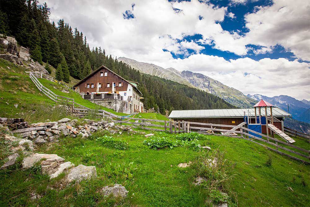
Kaunergrathütte (2,817 m)Place: St. Leonhard im Pitztal : Alpine pasture / hut / mountain restaurant see restaurant detailssee restaurant details: Kaunergrathütte (2,817 m)
Ludwigsburger Hütte (1,935 m)Place: St. Leonhard im Pitztal : Alpine pasture / hut / mountain restaurant see restaurant detailssee restaurant details: Ludwigsburger Hütte (1,935 m)
Riffelseehütte (2,293 m)Opening hours:Open todayPlace: St. Leonhard im Pitztal : Alpine pasture / hut / mountain restaurant see restaurant detailssee restaurant details: Riffelseehütte (2,293 m)
Rüsselsheimer Hütte (2,328 m)Place: St. Leonhard im Pitztal : Alpine pasture / hut / mountain restaurant see restaurant detailssee restaurant details: Rüsselsheimer Hütte (2,328 m)
Ötztal Trek Stage 19Difficulty: difficult Length: 11.0 km Duration: 5:00 h Elevation uphill: 1,246 m See trailSee trail: Ötztal Trek Stage 19
Arzler Alm – TiefentalalmDifficulty: medium Length: 11.3 km Duration: 5:00 h Elevation uphill: 1,000 m See trailSee trail: Arzler Alm – Tiefentalalm
Arzl - Benni-Raich-Bridge - WaldDifficulty: easy Length: 1.8 km Duration: 0:40 h Elevation uphill: 120 m See trailSee trail: Arzl - Benni-Raich-Bridge - Wald
St Leonharder Höhenweg (high-level trail)Difficulty: difficult Length: 16.9 km Duration: 9:00 h Elevation uphill: 1,390 m See trailSee trail: St Leonharder Höhenweg (high-level trail)
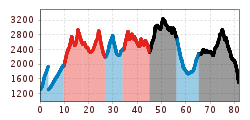
Trail to the Kaunergrathütte (2,817 m)Difficulty: medium Length: 12.5 km Duration: 7:00 h Elevation uphill: 1,220 m See trailSee trail: Trail to the Kaunergrathütte (2,817 m)
Trail to the Ludwigsburger HütteDifficulty: medium Length: 8.1 km Duration: 3:00 h Elevation uphill: 700 m See trailSee trail: Trail to the Ludwigsburger Hütte
Hike to RiegetalDifficulty: difficult Length: 7.5 km Duration: 4:00 h Elevation uphill: 690 m See trailSee trail: Hike to Riegetal
Panoramic tour Hochzeiger – Sechszeiger – Kalbenalm - Gondola top stationDifficulty: medium Length: 7.2 km Duration: 5:00 h Elevation uphill: 580 m See trailSee trail: Panoramic tour Hochzeiger – Sechszeiger – Kalbenalm - Gondola top station
Panorama hike Stuiben waterfallDifficulty: medium Length: 5.5 km Duration: 2:30 h Elevation uphill: 320 m See trailSee trail: Panorama hike Stuiben waterfall
Pitztal Alpine Pasture RouteDifficulty: medium Length: 11.4 km Duration: 5:30 h Elevation uphill: 800 m See trailSee trail: Pitztal Alpine Pasture Route
Braunschweiger HütteDifficulty: medium Length: 10.4 km Duration: 5:00 h Elevation uphill: 1,050 m See trailSee trail: Braunschweiger Hütte
Kaunergrat Circular Route - 3 DaysDifficulty: difficult Length: 22.8 km Duration: 3 days Elevation uphill: 2,650 m See trailSee trail: Kaunergrat Circular Route - 3 Days
Ötztal Trek Stage 18Difficulty: difficult Length: 9.5 km Duration: 9:30 h Elevation uphill: 979 m See trailSee trail: Ötztal Trek Stage 18
Give feedback for a chance to win a special holiday experience!Click here for the surveyClick here for the survey