
Difficulty:medium
Length:10.1 kmDuration:11:20 hElevation uphill:1,554 m
Starting at the parish church in Zams you go through the Patscheid to Kronburg and via Rifenal, along the Jakobsweg, back to Zams.

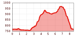
Starting at the parish church of Zams, the path leads you along a promenade with trees to the hospital (approx. 500 m). Follow the path below the hospital to the parking lot and the Inn cycle path. At the parking lot, turn right past the sewage treatment plant until you reach an underpass after approx. 1.7 km. Now you follow the signs "Kronburg" for approx. 2.1 km. You hike up through the Zammer Patscheid to Kronburg (945 m). When you go back you take the forest path approx. 2.1 km to Rifenal - from there you follow the signs "Jakobsweg" approx. 1.9 km until you reach the center of Zams.


.jpg")


.jpg")
