Winter hike Bschlabs - Zwieslen

Pfafflar / Lechtaler Alpen
Difficulty ratings: medium
Route length: 1.7 km
Duration: 0:40 h

Winter circuit to Zwieseln.

Tour information

  • Requirement: medium
  • Length: 1.7 km
  • Duration: 0:40 h
  • Elevation uphill:90 hm
Highest point1,405 m

Starting point

Church Bschlabs

Finishing point

Zwieslen

Features

  • Suitable for families

Best time of year

  • January
  • February
  • March
  • April
  • May
  • June
  • July
  • August
  • September
  • October
  • November
  • December

Trail condition

Groomed hiking trail

Equipment

Good equipment is essential for your hike. The following items should definitely be in your rucksack: - Food and drink - Functional clothing for rain, wind and cold - A change of clothes - Sun protection - First aid kit - Mobile phone with a full battery (Euro emergency number 112) - Hiking map or GPS - Hiking poles Nevertheless, the following applies: light luggage is also easier to carry, so you should not weigh down your rucksack with unnecessary ballast. In addition, your hiking equipment should of course also be adapted to your particular hiking tour.
Source: Lechtal

Description

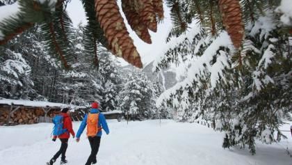
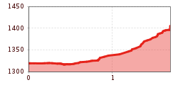
You start your walk in Bschlabs at an altitude of 1,324 metres, a settlement in the Lechtal municipality of Pfafflar. Your hike initially takes you along the road for around one kilometre and then leads you uphill to the hamlet of Zwieslen on the left.
After enjoying the peace and quiet, you walk back to Bschlabs along the same route.

Getting here

  • Arrival by public transport

    Regiobus Elmen - Bschlabs, outside the winter closure period

  • Parking

    Parking lot pilgrimage church "Maria Schnee" in Bschlabs

Newsletter

The mountain is calling? So does our newsletter!

In our monthly newsletter we reveal the best holiday tips for Tyrol.