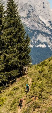
Hikes in St. Anton am Arlberg
Map

Show
on mapAlpine Rose Trail St. Anton
on mapAlpine Rose Trail St. Anton
Themed hikes
Starting point: Car park at ARLBERGwell.com
Length: 19km
Elevation uphill: 950m
Total hiking time: 7 h 15 min
Difficulty rating: intermediate (red mountain trails)

Show
on mapBerggeistweg St. Christoph
on mapBerggeistweg St. Christoph
Mountain hikes
Starting point: St. Christoph am Arlberg
Length: 15km
Elevation uphill: 780m
Total hiking time: 6 h 30 min
Difficulty rating: intermediate (red mountain trails)

Show
on mapLechtal High Trail
on mapLechtal High Trail
Long Distance Path
Starting point: Steeg (Lechtal Valley) / Stuttgarter Hütte hut
Length: 85km
Elevation uphill: 6,950m
Duration: 18 day(s)
Difficulty rating: difficult (black trails)

Show
on mapPutzen-Alpe
on mapPutzen-Alpe
Alpine hikes
Starting point: St. Anton am Arlberg, base station of the Nassereinbahn lifts
Length: 11km
Elevation uphill: 830m
Total hiking time: 3 h 30 min
Difficulty rating: intermediate (red mountain trails)

Show
on mapSt. Anton – Kapall – Leutkircher Hütte
on mapSt. Anton – Kapall – Leutkircher Hütte
Mountain hikes
Starting point: Top station Gampenbahn/Nassereinbahn, St. Anton am Arlberg
Length: 10km
Elevation uphill: 195m
Total hiking time: 4 h 30 min
Difficulty rating: difficult (black trails)
St. Anton am Arlberg: Hikes in the region

Zams
Ranking among the supreme ridge-running, cloud-probing, flower-swaying,…

Zams
Gullies resemble large ditches, small valleys or narrow chasms, carved into…

Kaisers
Starting at a little under 2,400 metres in elevation and never dropping…