Road bike tour Gerlos Circuit, Tour Nr. 10

Route length: 175.0 km
Duration: 5:00 h

A long and demanding mountain stage with two passes and rapid descents. Awesome panorama with glorious views of the glacier.

Tour information

  • Length: 175.0 km
  • Duration: 5:00 h
  • Elevation uphill:2,303 hm
Highest point1,628 m

Starting point

Kitzbühel - Stadtzentrum

Finishing point

Kitzbühel - Stadtzentrum

Best time of year

  • January
  • February
  • March
  • April
  • May
  • June
  • July
  • August
  • September
  • October
  • November
  • December

Equipment

road bike, helmet, clothing according to weather, light wind jacket recommended, sun blocker and sufficient drinks

Description

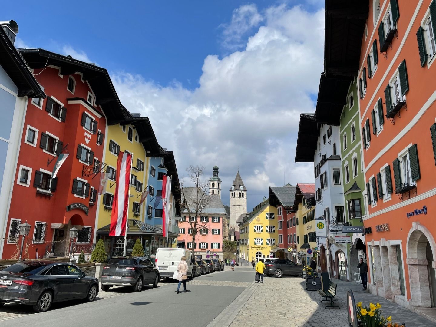
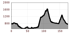
From Kitzbühel town centre head along the Schwarzseestraße. As per tour number 7, head west on the Brixental bike path as far as Wörgl. Proceed through the centre of Wörgl then follow the Inn bike path past the Reintaler lakes and on into the Zillertal (Zillertal bike path). Proceed along side-roads with light traffic until you reach the access point to the Gerlos pass (1,620 m, gradients of up to 10 %) in Zell am Ziller. Reaching the top, follow the plateau (Almdorf Königsleiten) that leads to a rapid descent to the Krimml waterfalls. From Krill, either take the Pinzgau bike path or the fast-paced secondary road with little traffic towards Mittersill. At Hollersbach be sure to turn onto the bike path and go through the hamlet of Rettenbach onto the old Pass- Thurn-Straße. Here continue along an unpaved stretch (unproblematic) then turn onto the Pass-Thurn federal road (B 161). Enjoy the pleasant consistent ascent (mostly well under 10 %) to the top of the pass (1,274 m) and the swift descent (long straights!) to Jochberg. Follow the federal road (Bundesstraße) to Kitzbühel.

More tours in the surrounding area

  • Klammljoch - Defereggental No. 102

    Difficulty: medium
    Length: 22.0 km Duration: 3:30 h Elevation uphill: 946 m
  • 694 Amberger Hütte

    Opening hours: closed
    Difficulty: medium
    Length: 23.7 km Duration: 3:00 h Elevation uphill: 960 m
  • Supernatural

    Opening hours: open
    Difficulty: medium
    Length: 610 m
  • Ehrwalder Alm Seebensee

    Difficulty: medium
    Length: 9.0 km Duration: 2:30 h Elevation uphill: 630 m
  • Lechradweg

    Length: 244.6 km Duration: 18:00 h Elevation uphill: 1,702 m
  • Milky Way

    Opening hours: closed
    Difficulty: easy
    Length: 2.9 km
  • Uphill Idalp I.3

    Difficulty: medium
    Length: 7.8 km Duration: 2:00 h Elevation uphill: 967 m
  • Angereralm - Harschbichl

    Difficulty: medium
    Length: 18.2 km Duration: 2:00 h Elevation uphill: 942 m
  • MTB Tour Söll - Hochsöll

    Difficulty: medium
    Length: 5.1 km Elevation uphill: 480 m
  • Culinary bike route. Through the region

    Difficulty: easy
    Length: 25.1 km Duration: 2:00 h Elevation uphill: 302 m
  • Wildbachtrail

    Difficulty: difficult
    Length: 3.4 km Duration: 0:30 h Elevation uphill: 480 m
  • Alpbachtal Giro

    Difficulty: difficult
    Length: 117.4 km Duration: 5:45 h Elevation uphill: 2,250 m
  • Wilder Kaiser cycle route no. 14

    Difficulty: medium
    Length: 38.3 km Elevation uphill: 520 m
  • Fernar Trail (6041)

    Difficulty: difficult
    Length: 6.0 km Duration: 0:49 h Elevation uphill: 18 m
Newsletter

The mountain is calling? So does our newsletter!

In our monthly newsletter we reveal the best holiday tips for Tyrol.