Mountain hikes Approach Innsbrucker Hütte

closed
Gschnitz / Stubaier Alpen
Difficulty ratings: medium
Route length: 5.5 km
Duration: 6:30 h

This beautifully laid out hiking trail to the Innsbrucker Hütte starts at the "Kichplatz" bus stop. From here, follow the road for a few metres to the "Innsbrucker Hütte" car park shortly after the village on the northern side of the valley. The path along the stream starts directly at the end of the car park.
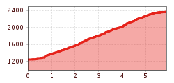
Tour information

  • Requirement: medium
  • Length: 5.5 km
  • Duration: 6:30 h
  • Elevation uphill:1,100 hm
  • Elevation downhill:1,100 hm
Highest point2,369 m

Starting point

Parkplatz Innsbrucker Hütte

Finishing point

Innsbrucker Hütte
  • Fitness level 3 / 6
  • Technique 3 / 6

Best time of year

  • January
  • February
  • March
  • April
  • May
  • June
  • July
  • August
  • September
  • October
  • November
  • December

Trail condition

Red Mountain Trail, Steig

Equipment

Good shoes, water, rain and sun protection
Source: Wipptal

Description

The ascent runs over numerous serpentines on Jubiläumssteig No. 123, one section in the upper area is secured.

Nearby huts and mountain restaurants

Getting here

  • Arrival by public transport

    Take the regional bus 4146 in the direction of "Gschnitz" from Steinach a. Br. railway station to Gschnitz to the Kirchplatz bus stop. Then walk a short distance along the road into the valley and the hiking trail starts at the Innsbrucker Hütte car park. Exact timetables can be found at www.vvt.at. Free use of the bus with the Wipptal Guest Card!

  • Parking

    "Innsbrucker Hütte" car park (subject to charges)

More tours in the surrounding area

Newsletter

The mountain is calling? So does our newsletter!

In our monthly newsletter we reveal the best holiday tips for Tyrol.