Mountain hikes Circular walk suspension bridge Kals am Großglockner

closed
Kals am Großglockner /
Difficulty ratings: medium

An exciting short hike

Tour information

  • Requirement: medium
  • Elevation uphill:0 hm
  • Elevation downhill:0 hm
  • Fitness level 2 / 6
  • Technique 2 / 6

Features

  • Circular route

Best time of year

  • January
  • February
  • March
  • April
  • May
  • June
  • July
  • August
  • September
  • October
  • November
  • December

Trail condition

Forest path, grating on suspension bridge, trail

Equipment

suitable footwear
Source: TVB Osttirol

Description

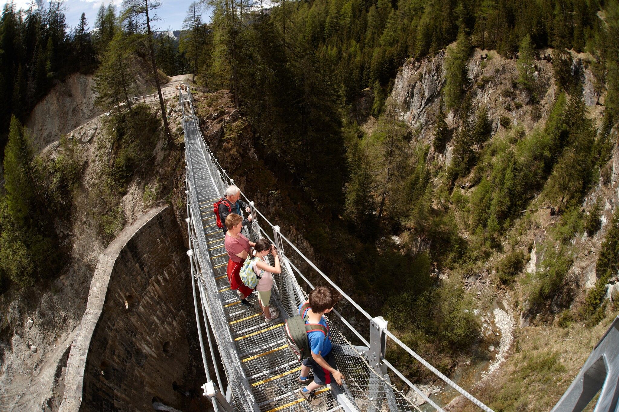
The starting point is the district of Glor. There, the sign for the suspension bridge points to the right and you cross the Ködnitzbach stream via a normal wooden bridge. A forest path leads upstream until you reach the suspension bridge in about 20 minutes. This bridge is 30 metres above the Ködnitzbach gorge. The suspension bridge is 50 metres long and has a grid that you can see through. The route continues along a narrow, winding path (path no. 37c) until you reach the Alten Lucknerhausweg no. 702B, a forest path. Follow this path downhill for the return journey until you reach Glor again.

More tours in the surrounding area

  • Lasörling altitude trail

    Difficulty: medium
    Length: 57.0 km Duration: 25:00 h Elevation uphill: 3,740 m
  • Venediger altitude trail

    Difficulty: difficult
    Length: 55.5 km Duration: 27:00 h Elevation uphill: 3,915 m
  • Figerhorn

    Difficulty: difficult
    Length: 6.5 km Duration: 6:00 h Elevation uphill: 807 m
  • Hike to the Venedigerhaus Innergschlöß

    Difficulty: easy
    Length: 8.5 km Duration: 2:30 h Elevation uphill: 180 m
  • Rotenkogel

    Difficulty: difficult
    Length: 3.9 km Duration: 3:00 h Elevation uphill: 383 m
  • Lasörling 3.098m

    Difficulty: difficult
    Length: 21.9 km Duration: 12:00 h Elevation uphill: 1,940 m
  • Umbal waterfalls nature force trail

    Difficulty: easy
    Length: 5.8 km Duration: 2:30 h Elevation uphill: 250 m
  • Muhs panorama trail

    Difficulty: medium
    Length: 15.2 km Duration: 6:00 h Elevation uphill: 1,090 m
  • Hike to Neuen Reichenberger Hütte

    Difficulty: medium
    Length: 9.1 km Duration: 9:00 h Elevation uphill: 1,210 m
  • Hiking tour to Lasörlinghütte 2.350m

    Difficulty: medium
    Length: 14.6 km Duration: 7:10 h Elevation uphill: 1,080 m
  • Badener Hütte

    Difficulty: difficult
    Length: 23.2 km Duration: 11:30 h Elevation uphill: 1,750 m
  • Lucknerhaus - Stüdlhütte

    Difficulty: medium
    Length: 9.3 km Duration: 5:30 h Elevation uphill: 862 m
  • Hike to Kalser Tauernhaus

    Difficulty: medium
    Length: 12.2 km Duration: 4:00 h Elevation uphill: 244 m
  • Hiking tour to Neue Sajathütte 2.600m

    Difficulty: medium
    Length: 10.3 km Duration: 6:50 h Elevation uphill: 1,080 m
  • Böses Weibl

    Difficulty: difficult
    Length: 14.1 km Duration: 8:00 h Elevation uphill: 1,193 m
  • Eagle Walk Stage O1: Ströden - Johannis Hütte

    Difficulty: medium
    Length: 13.0 km Duration: 6:30 h Elevation uphill: 1,430 m
Newsletter

The mountain is calling? So does our newsletter!

In our monthly newsletter we reveal the best holiday tips for Tyrol.