Mountain hikes Kühtai - Pirchkogel - Marlstein

Difficulty ratings: medium
Route length: 14.9 km

Kühtai - Pirchkogel - Marlstein

Tour information

  • Requirement: medium
  • Length: 14.9 km
  • Elevation uphill:1,151 hm
  • Elevation downhill:0 hm
Highest point2,828 m
Source: Innsbruck Tourismus

Description

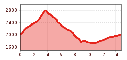
This hike starts behind the tourist information centre and leads uphill past the "baby lift" and along Stocktaler Bach stream. Cross the stream on the wooden bridge behind the fenced off reservoir and follow the marked trail up to the bottom of the ski lift track. There you will meet the AV151 trail, which runs below the Irzwände mountains and over Stockacher Böden along the upper ski lift before crossing scree fields to the summit. The route back down leads west along the AV151 to the crossroads at Feldringer Böden. From there, continue past Marlstein and Mareil before joining the Kaiser-Franz-Josef-Weg trail and walking back up to the Jagdschloss Kühtai restaurant. Finally, follow the road back to the tourist information centre.

More tours in the surrounding area

  • Kundler Klamm

    Opening hours: closed
    Difficulty: easy
    Length: 6.4 km Duration: 2:00 h Elevation uphill: 116 m
  • Kaiser Gorge - loop trail

    Opening hours: closed
    Difficulty: easy
    Length: 4.2 km Duration: 1:00 h Elevation uphill: 198 m
  • 3-peak-tour Kienberg-Plessenberg-Heuberg

    Difficulty: medium
    Length: 8.6 km Duration: 4:30 h Elevation uphill: 779 m
  • 4 days - 4 summits tour

    Difficulty: medium
    Length: 54.4 km Duration: 23:00 h Elevation uphill: 3,408 m
  • Discovering the Tiefenbach Gorge Hike

    Opening hours: closed
    Difficulty: medium
    Length: 5.7 km Duration: 3:30 h Elevation uphill: 669 m
  • Voldöpper Spitze Loop Hike

    Difficulty: medium
    Length: 12.9 km Duration: 5:00 h Elevation uphill: 988 m
  • Loop tour Juppi Zauberwald

    Difficulty: easy
    Length: 2.5 km Duration: 1:00 h Elevation uphill: 93 m
  • Day 1: 4 days - 4 summits tour

    Difficulty: medium
    Length: 9.8 km Duration: 5:00 h Elevation uphill: 984 m
  • Wheelchair Circular Hike Runst-Achweg

    Difficulty: easy
    Length: 6.3 km Duration: 2:00 h Elevation uphill: 40 m
  • Ötztal Trek Stage 4

    Difficulty: difficult
    Length: 8.9 km Duration: 4:00 h Elevation uphill: 802 m
  • Ötztal Trek Stage 3

    Difficulty: difficult
    Length: 10.4 km Duration: 4:00 h Elevation uphill: 842 m
  • Ötztal Trek Stage 8

    Difficulty: difficult
    Length: 9.3 km Duration: 3:30 h Elevation uphill: 274 m
  • Ötztal Trek Stage 1

    Difficulty: medium
    Length: 18.6 km Duration: 6:30 h Elevation uphill: 1,561 m
  • Ötztal Trek Stage 14

    Difficulty: difficult
    Length: 6.3 km Duration: 3:00 h Elevation uphill: 1,004 m
  • Ötztal Trek Stage 18

    Difficulty: difficult
    Length: 9.5 km Duration: 9:30 h Elevation uphill: 979 m
  • Ötztal Trek Stage 12

    Difficulty: difficult
    Length: 4.8 km Duration: 2:00 h Elevation uphill: 592 m
  • Ötztal Trek Stage 22

    Difficulty: difficult
    Length: 21.5 km Duration: 8:00 h Elevation uphill: 647 m
Newsletter

The mountain is calling? So does our newsletter!

In our monthly newsletter we reveal the best holiday tips for Tyrol.