Arrival by public transport
Take the S-Bahn to Steinach a.B. and walk or take bus 4145 from Steinach a. Br. station to " Steinach a. Br. Bergeralm" (terminal stop) [exact journey times at www.vvt.at]
Beautiful and easy round tour of the summit, which is rounded off with a stop at the Bärnealm & Bergeralmhütte.

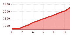
The gondola of the Bergeralm cable car takes you comfortably up to over 1,500 metres in altitude. Alternatively, you can also take the hiking trail that starts at Steinach station and leads to the Bergeralm valley station. Continue straight on and take the forest path to the left over the Gschnitzer Bach stream and keep left. The path leads to the middle station and on to the top station. From there it is only 100m further on the marked trail no. 41 to the summit of the Nösslachjoch with a fantastic panoramic view.
Take the S-Bahn to Steinach a.B. and walk or take bus 4145 from Steinach a. Br. station to " Steinach a. Br. Bergeralm" (terminal stop) [exact journey times at www.vvt.at]
Parking lot at the Bergeralm (subject to charges)