Hut hike Pertisau - Pletzachalm - Gern Alm - Pertisau

Difficulty ratings: easy
Route length: 10.7 km
Duration: 3:30 h

Starting in Pertisau, this walk leads through the gentle Gerntal Valley in the Karwendel Nature Park – via the Pletzachalm to the Gern Alm at the end of the valley, out and back.

Tour information

  • Requirement: easy
  • Length: 10.7 km
  • Duration: 3:30 h
  • Elevation uphill:195 hm
  • Elevation downhill:195 hm
Highest point1,172 m

Starting point

Pertisau, toll booth at the entrance to the Karwendel valleys

Finishing point

Pertisau, toll booth at the entrance to the Karwendel valleys
  • Fitness level 2 / 6
  • Technique 1 / 6

Features

  • Suitable for families

Best time of year

  • January
  • February
  • March
  • April
  • May
  • June
  • July
  • August
  • September
  • October
  • November
  • December

Trail condition

forest road, forest path

Equipment

Sturdy boots (ankle-high hiking boots), weather appropriate clothing. Telescopic hiking poles are recommended.
Source: Achensee Tourismus

Description

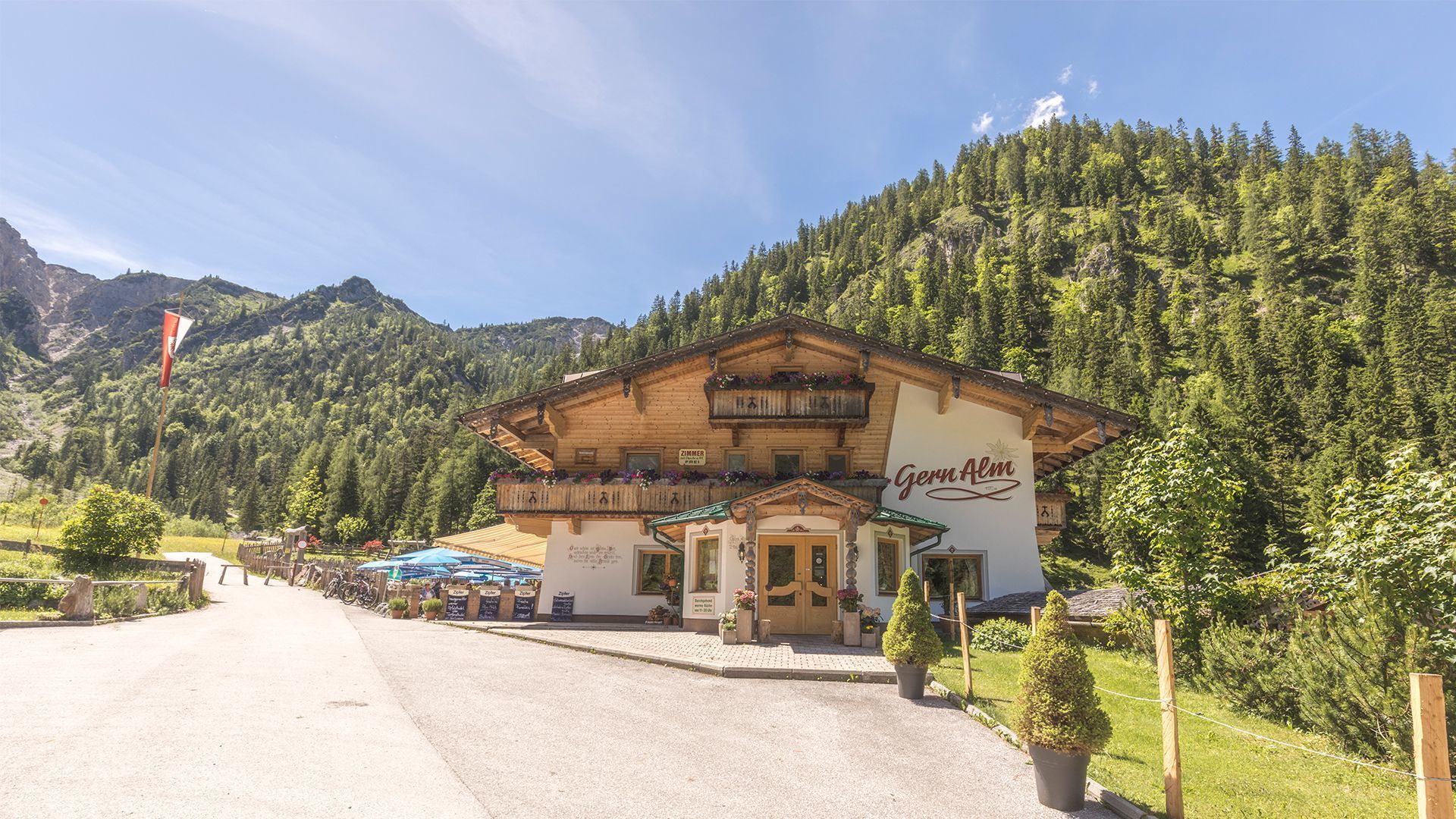
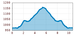
From the toll booth at the entrance to the Karwendel valleys (952 metres) turn right and walk along the Seebergsteig trail. Follow the signpost to the Pletzachalm mountain hut (1,040 metres, time ca. 1 hour). In continue to the Gern Alm mountain hut (1,172 metres), turn right before the Pletzachalm and follow the scenic trail through the forest. The return is via the same route.

Nearby huts and mountain restaurants

  • Alpengasthaus Pletzachalm

    Opening hours:Open today
    Place: Pertisau am Achensee
    : Restaurant, Alpine pasture / hut / mountain restaurant
  • Alpengasthof Gern Alm

    Opening hours:Open today
    Place: Pertisau am Achensee
    : Restaurant, Alpine pasture / hut / mountain restaurant : vegetarian

Getting here

  • Arrival by public transport

    Take the regional bus (line 8332 or 390) to Pertisau and get off at the "Pertisau Karwendeltäler" stop.

  • Parking

    Car park Karwendeltäler in Pertisau (paid parking)

More tours in the surrounding area

  • Wilder-Kaiser-Steig - Detour

    Difficulty: difficult
    Length: 33.0 km Duration: 16:49 h Elevation uphill: 2,311 m
  • Kundler Klamm

    Opening hours: closed
    Difficulty: easy
    Length: 6.4 km Duration: 2:00 h Elevation uphill: 116 m
  • Day 3: 4 days - 4 summits tour

    Difficulty: medium
    Length: 19.3 km Duration: 8:00 h Elevation uphill: 1,371 m
  • Kaiser Gorge - loop trail

    Opening hours: closed
    Difficulty: easy
    Length: 4.2 km Duration: 1:00 h Elevation uphill: 198 m
  • 3-day Family Tour Alpbachtal

    Difficulty: easy
    Length: 18.3 km Duration: 7:00 h Elevation uphill: 998 m
  • Farmkehralm 1.521 m

    Difficulty: medium
    Length: 9.3 km Duration: 3:30 h Elevation uphill: 506 m
  • Wiedersberger Horn Panorama Path

    Difficulty: easy
    Length: 4.1 km Duration: 1:30 h Elevation uphill: 195 m
  • Barrier-free path Lake Reintal

    Difficulty: easy
    Length: 6.5 km Duration: 1:45 h Elevation uphill: 15 m
  • 3-peak-tour Kienberg-Plessenberg-Heuberg

    Difficulty: medium
    Length: 8.6 km Duration: 4:30 h Elevation uphill: 779 m
  • 4 days - 4 summits tour

    Difficulty: medium
    Length: 54.4 km Duration: 23:00 h Elevation uphill: 3,408 m
  • Discovering the Tiefenbach Gorge Hike

    Opening hours: closed
    Difficulty: medium
    Length: 5.7 km Duration: 3:30 h Elevation uphill: 669 m
  • Voldöpper Spitze Loop Hike

    Difficulty: medium
    Length: 12.9 km Duration: 5:00 h Elevation uphill: 988 m
  • Loop tour Juppi Zauberwald

    Difficulty: easy
    Length: 2.5 km Duration: 1:00 h Elevation uphill: 93 m
  • Day 1: 4 days - 4 summits tour

    Difficulty: medium
    Length: 9.8 km Duration: 5:00 h Elevation uphill: 984 m
  • Wheelchair Circular Hike Runst-Achweg

    Difficulty: easy
    Length: 6.3 km Duration: 2:00 h Elevation uphill: 40 m
Newsletter

The mountain is calling? So does our newsletter!

In our monthly newsletter we reveal the best holiday tips for Tyrol.