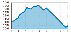
Open interactive mapOpen this POI on the interactive mapElevation profileHöfe Trail stage 5: St. Lorenzen im Lesachtal - Liesing im Lesachtal.gpx
3-Länder TrailOpening hours: closed Difficulty: medium Length: 3.4 km Go to biketourGo to biketour: 3-Länder Trail
Plamort TrailOpening hours: closed Difficulty: Very easy Length: 2.5 km Go to biketourGo to biketour: Plamort Trail
Oberer Gerry TrailOpening hours: open Difficulty: medium Length: 1.2 km Go to biketourGo to biketour: Oberer Gerry Trail
3-hut hikeDifficulty: medium Length: 13.2 km Duration: 6:00 h Elevation uphill: 1,120 m See trailSee trail: 3-hut hike
495 - Singletrail Isskogel (495 Iss-Tough 1-2)Opening hours: closed Difficulty: medium Length: 300 m Duration: 0:06 h Elevation uphill: 9 m Go to biketourGo to biketour: 495 - Singletrail Isskogel (495 Iss-Tough 1-2)
Faltegartenköpfl peakDifficulty: medium Length: 8.5 km Duration: 4:30 h Elevation uphill: 509 m See trailSee trail: Faltegartenköpfl peak
JuifenalmDifficulty: easy Length: 9.5 km Duration: 4:18 h Elevation uphill: 585 m See trailSee trail: Juifenalm
Kühtai - SulzkogelDifficulty: medium Length: 12.7 km Duration: 7:21 h Elevation uphill: 1,079 m See trailSee trail: Kühtai - Sulzkogel
Hike via Nördlinger Hütte to Reither SpitzeDifficulty: difficult Length: 9.9 km Duration: 7:30 h Elevation uphill: 1,191 m See trailSee trail: Hike via Nördlinger Hütte to Reither Spitze
Venediger altitude trailDifficulty: difficult Length: 55.5 km Duration: 27:00 h Elevation uphill: 3,915 m See trailSee trail: Venediger altitude trail
FigerhornDifficulty: difficult Length: 6.5 km Duration: 6:00 h Elevation uphill: 807 m See trailSee trail: Figerhorn
Carnic altitude trail. Stage 4: Porzehütte – HochweißsteinhausMore InformationMore Information: Carnic altitude trail. Stage 4: Porzehütte – Hochweißsteinhaus
Karwendelmarsch 52 kmDifficulty: difficult Length: 52.0 km Duration: 19:00 h Elevation uphill: 2,281 m See trailSee trail: Karwendelmarsch 52 km
Bergdoktor-Winter Hiking TrailDifficulty: easy Length: 2.1 km Duration: 0:45 h Elevation uphill: 40 m See trailSee trail: Bergdoktor-Winter Hiking Trail
Hochfügen - Kleiner Gilfert (2388m) Walk no. 27Difficulty: medium Length: 14.4 km Duration: 6:00 h Elevation uphill: 925 m See trailSee trail: Hochfügen - Kleiner Gilfert (2388m) Walk no. 27
Carnic altitude trail. Stage 3: Obstansersee Hütte – PorzehütteDifficulty: medium Length: 11.3 km Duration: 6:00 h Elevation uphill: 650 m See trailSee trail: Carnic altitude trail. Stage 3: Obstansersee Hütte – Porzehütte
Biathlon centre competition and training trail ObertilliachOpening hours: open Difficulty: difficult Length: 4.2 km Elevation uphill: 100 m : Style: Skating, Classic Go to Cross-country skiing trailGo to Cross-country skiing trail: Biathlon centre competition and training trail Obertilliach
Carnic altitude trail. Stage 1: Arnbach - Sillianer HütteDifficulty: easy Length: 9.5 km Elevation uphill: 1,350 m See trailSee trail: Carnic altitude trail. Stage 1: Arnbach - Sillianer Hütte
Siegerlandhütte - SöldenDifficulty: medium Length: 8.0 km Duration: 3:30 h Elevation uphill: 780 m See trailSee trail: Siegerlandhütte - Sölden
Panorama Restaurant and WIDIVERSUM HochoetzDifficulty: easy Length: 2.8 km Duration: 0:04 h Elevation uphill: 1,216 m See trailSee trail: Panorama Restaurant and WIDIVERSUM Hochoetz
Höfe Trail stage 4: Wacht/Untertilliach – St. Lorenzen im LesachtalMore InformationMore Information: Höfe Trail stage 4: Wacht/Untertilliach – St. Lorenzen im Lesachtal
Scenic nature site: GletscherblickMore InformationMore Information: Scenic nature site: Gletscherblick
01.2 Panoramic tour through IschglMore InformationMore Information: 01.2 Panoramic tour through Ischgl
Around the Lienz DolomitesDifficulty: medium Length: 112.0 km Duration: 3:30 h Elevation uphill: 1,870 m Go to biketourGo to biketour: Around the Lienz Dolomites
Talwanderweg KaunertalDifficulty: easy Duration: 2:30 h Elevation uphill: 295 m See trailSee trail: Talwanderweg Kaunertal
Give feedback for a chance to win a special holiday experience!Click here for the surveyClick here for the survey
.jpg")
")


.jpg")

")


.jpg")


