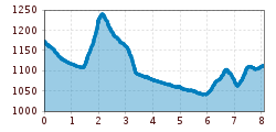
Open interactive mapOpen this POI on the interactive mapElevation profileHöfe Trail stage 4: Wacht/Untertilliach – St. Lorenzen im Lesachtal.gpx
Muhs panorama trailDifficulty: medium Length: 15.2 km Duration: 6:00 h Elevation uphill: 1,090 m See trailSee trail: Muhs panorama trail
Carnic altitude trail. Stage 4: Porzehütte – HochweißsteinhausMore InformationMore Information: Carnic altitude trail. Stage 4: Porzehütte – Hochweißsteinhaus
Venediger altitude trailDifficulty: difficult Length: 55.5 km Duration: 27:00 h Elevation uphill: 3,915 m See trailSee trail: Venediger altitude trail
FigerhornDifficulty: difficult Length: 6.5 km Duration: 6:00 h Elevation uphill: 807 m See trailSee trail: Figerhorn
Biathlon centre competition and training trail ObertilliachOpening hours: closed Difficulty: difficult Length: 4.2 km Elevation uphill: 100 m : Style: Skating, Classic Go to Cross-country skiing trailGo to Cross-country skiing trail: Biathlon centre competition and training trail Obertilliach
Herz-Ass VillgratentalDifficulty: medium Length: 76.0 km Duration: 34:00 h Elevation uphill: 5,750 m See trailSee trail: Herz-Ass Villgratental
Lasörling altitude trailDifficulty: medium Length: 57.0 km Duration: 25:00 h Elevation uphill: 3,740 m See trailSee trail: Lasörling altitude trail
Carnic altitude trail. Stage 3: Obstansersee Hütte – PorzehütteDifficulty: medium Length: 11.3 km Duration: 6:00 h Elevation uphill: 650 m See trailSee trail: Carnic altitude trail. Stage 3: Obstansersee Hütte – Porzehütte
Carnic altitude trail. Stage 2: Sillianer Hütte- Obstansersee HütteDifficulty: medium Length: 8.7 km Elevation uphill: 503 m See trailSee trail: Carnic altitude trail. Stage 2: Sillianer Hütte- Obstansersee Hütte
Klammljoch - Defereggental No. 102Difficulty: medium Length: 44.0 km Duration: 5:30 h Elevation uphill: 980 m Go to biketourGo to biketour: Klammljoch - Defereggental No. 102
Badener HütteDifficulty: difficult Length: 23.2 km Duration: 11:30 h Elevation uphill: 1,750 m See trailSee trail: Badener Hütte
Lucknerhaus - StüdlhütteDifficulty: medium Length: 9.3 km Duration: 5:30 h Elevation uphill: 862 m See trailSee trail: Lucknerhaus - Stüdlhütte
IseltrailDifficulty: medium Length: 75.3 km Duration: 24:30 h Elevation uphill: 2,348 m See trailSee trail: Iseltrail
Hiking tour to Sudetendeutschen Hütte 2.650mDifficulty: medium Length: 15.5 km Duration: 7:00 h Elevation uphill: 1,200 m See trailSee trail: Hiking tour to Sudetendeutschen Hütte 2.650m
Hike to the Berghaus AußergschlössDifficulty: easy Length: 5.2 km Duration: 1:45 h Elevation uphill: 170 m See trailSee trail: Hike to the Berghaus Außergschlöss
Hike to Neuen Reichenberger HütteDifficulty: medium Length: 9.1 km Duration: 9:00 h Elevation uphill: 1,210 m See trailSee trail: Hike to Neuen Reichenberger Hütte
Hike to Kalser TauernhausDifficulty: medium Length: 12.2 km Duration: 4:00 h Elevation uphill: 244 m See trailSee trail: Hike to Kalser Tauernhaus
Hiking tour to Lasörlinghütte 2.350mDifficulty: medium Length: 14.6 km Duration: 7:10 h Elevation uphill: 1,080 m See trailSee trail: Hiking tour to Lasörlinghütte 2.350m
Hiking tour to Neue Sajathütte 2.600mDifficulty: medium Length: 10.3 km Duration: 6:50 h Elevation uphill: 1,080 m See trailSee trail: Hiking tour to Neue Sajathütte 2.600m
Höfe Trail stage 2: Kartitsch - ObertilliachDifficulty: easy Length: 10.8 km Duration: 3:45 h Elevation uphill: 435 m See trailSee trail: Höfe Trail stage 2: Kartitsch - Obertilliach
Höfe Trail stage 3: Obertilliach - Wacht/UntertilliachMore InformationMore Information: Höfe Trail stage 3: Obertilliach - Wacht/Untertilliach
The Höfe TrailDifficulty: easy Length: 50.6 km Duration: 10:15 h Elevation uphill: 1,882 m See trailSee trail: The Höfe Trail
Give feedback for a chance to win a special holiday experience!Click here for the surveyClick here for the survey


")


Erwin Haiden, bikeboard.at.jpg")


www.bergpixel.de")


.jpg")
.jpg")
.jpg")
