Hut Forchheimer Biwak

The Forchheimer Biwak (2,443 metres) is a small emergency shelter high in the Ötztal Alps, Tirol.

Information

Altitude

2,443 m

Mountain range

Ötztal Alps

Facilities

  • Self catering hut

Coordinates

  • Geographic length:10.826944444444
  • Geographic width:47.17
  • UTM (east):5225683
  • UTM (east):638459
  • Reference Meridian:
Source: Alpenverein

Description

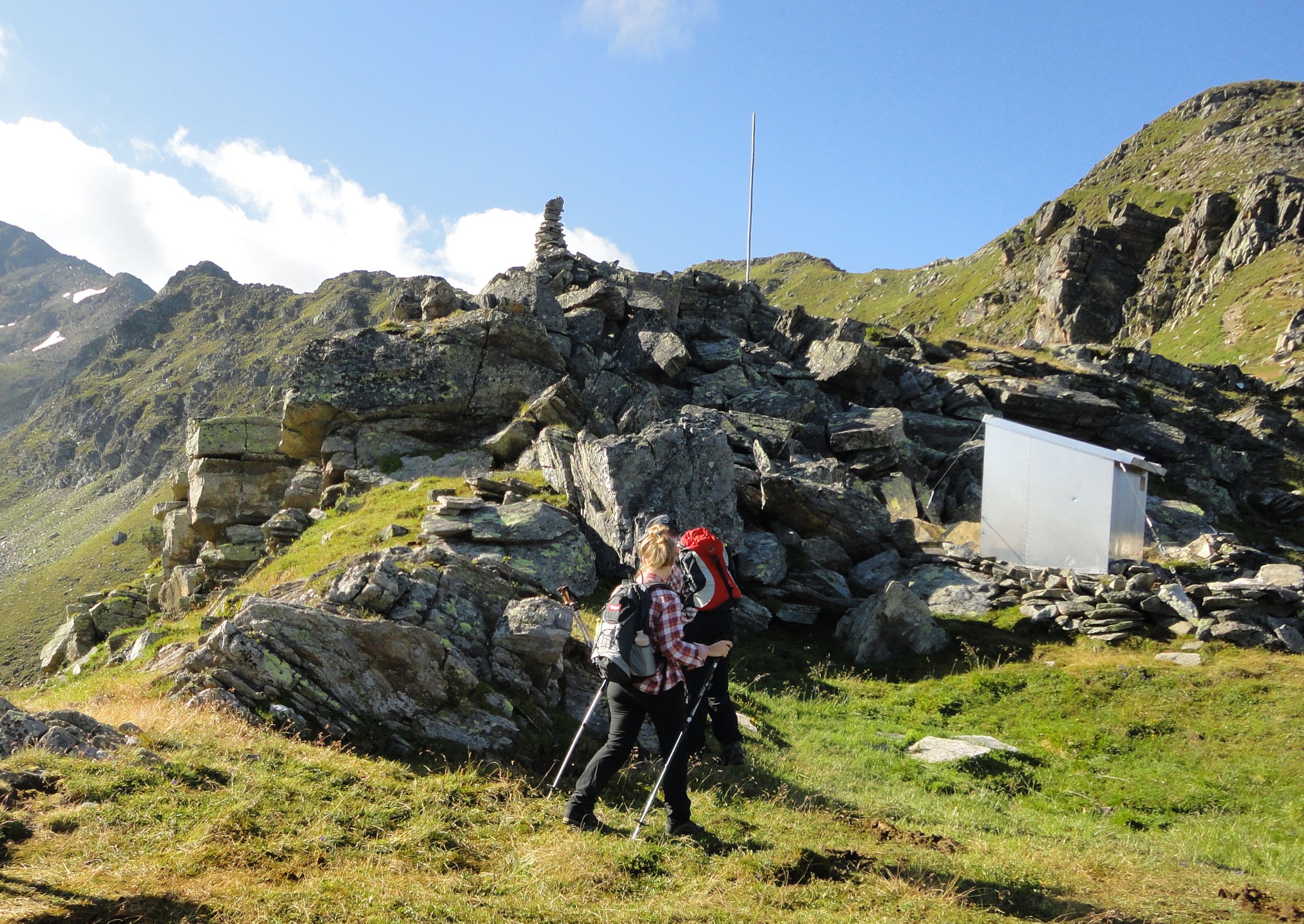
Emergency shelter on the Forchheim Trail in the Ötztal Valley
German Alpine Club, Forchheim Division

This basic shelter high in the Ötztal Alps is nothing more than a simple metal shack providing protection from the elements. Food and water must be brought by walkers and hikers themselves. The shelter lies on the Forchheim Trail, which traces the Geigenkamm ridge in the Ötztal Alps. The route begins in Roppen in the Inn Valley and leads up into the high alpine terrain around the Erlanger Hütte. The Forchheim Division of the German Alpine Club has been active in this region since the 1930s. In 1932 they created the Forchheim Trail. In 1963 this refuge was added by young members of the division in order to provide a place to stay on the long trek from Roppen. There are plenty of interesting walks and hikes around the refuge, which include summit adventures to the top of the Wildgratspitze.

How to get to the hut

From the Maisalm hut (2.5 hours), from Roppen (4.5 hours).

Walks and hikes in the area (walking time to summit)

Mutzeiger (2,277 metres), 40 minutes, intermediate
Maisalm (1,631 metres), 2.5 hours, intermediate
Wildgratspitze (2,974 metres), 5 hours, difficult

Further huts in the area, long-distance hiking trails

Erlanger Hütte, 3 hours

The Forchheimer Biwakschachtel lies on the Ötztal Trek (Stage 22).

Getting here

Nearby huts

  • Erlanger Hütte

    Place:Ötztal Alps
    :2,550 m
    :Suitable formountain hikingHigh-altitude hikesSki touring
  • Falkenhütte

    Place:Karwendel Mountains
    :1,848 m
    :Suitable formountain hikingRock climbingMountain bikeSki touring
  • Friesenberghaus

    Place:Zillertal Alps
    :2,498 m
    :Suitable formountain hikingHigh-altitude hikes
  • Furtschaglhaus

    Place:Zillertal Alps
    :2,295 m
    :Suitable formountain hikingHigh-altitude hikesRock climbing
  • Gepatschhaus

    Place:Ötztal Alps
    :1,928 m
    :Suitable formountain hikingHigh-altitude hikesRock climbingMountain bikeSki touring
  • Greizer Hütte

    Place:Zillertal Alps
    :2,227 m
    :Suitable formountain hikingHigh-altitude hikesRock climbingSki touring
  • Grünseehütte

    Place:Granatspitz Mountains
    :2,235 m
    :Suitable formountain hikingMountain bikeSki touring
  • Gufferthütte

    Place:Rofan Mountains
    :1,475 m
    :Suitable formountain hikingRock climbingMountain bikeSki touring
  • Hanauer Hütte

    Place:Lechtal Alps
    :1,922 m
    :Suitable formountain hikingRock climbingSki touring
  • Amberger Hütte

    Place:Stubai Alps
    :2,135 m
    :Suitable formountain hikingHigh-altitude hikesRock climbingMountain bikeSki touring
  • Ansbacher Hütte

    Place:Lechtal Alps
    :2,376 m
    :Suitable formountain hikingRock climbing
  • Hermann-von-Barth-Hütte

    Place:Allgäu Alps
    :2,131 m
    :Suitable formountain hikingRock climbing
  • Ascher Hütte

    Place:Samnaun Mountains
    :2,256 m
    :Suitable formountain hikingHigh-altitude hikesSki touring
  • Hochjoch-Hospiz

    Place:Ötztal Alps
    :2,413 m
    :Suitable forHigh-altitude hikesSki touring
  • Bad Kissinger Hütte

    Place:Allgäu Alps
    :1,788 m
    :Suitable formountain hikingRock climbing
  • Bayreuther Hütte

    Place:Rofan Mountains
    :1,576 m
    :Suitable formountain hikingRock climbingMountain bike
  • Hochwildehaus

    Place:Ötztal Alps
    :2,885 m
    :Suitable forHigh-altitude hikesSki touring
  • Hohenzollernhaus

    Place:Ötztal Alps
    :2,123 m
    :Suitable formountain hikingHigh-altitude hikesRock climbingSki touring
  • Innsbrucker Hütte

    Place:Stubai Alps
    :2,369 m
    :Suitable formountain hikingHigh-altitude hikesRock climbing
  • Bettelwurf Hütte

    Place:Karwendel Mountains
    :2,077 m
    :Suitable formountain hikingRock climbingMountain bike
  • Bonn-Matreier-Hütte

    Place:Venediger Mountains
    :2,750 m
    :Suitable formountain hikingHigh-altitude hikesRock climbingMountain bike
Newsletter

The mountain is calling? So does our newsletter!

In our monthly newsletter we reveal the best holiday tips for Tyrol.