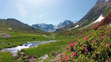
The Vernagthütte (2,755 metres) is a mountain refuge at the end of the Rofental Valley and an important base for hikes and glacier crossings in the Ötztal Alps.
Perfect base camp for climbing 3,000m mountains
German Alpine Club, Würzburg Division
This hut enjoys a beautiful location in a high-alpine environment, surrounded by the mighty peaks of the Ötztal Alps, between the Guslarferner and the Vernagtferner glaciers. Its position on the Weißkamm. ridge makes it an excellent base from which to climb a number of peaks over 3,000 metres in altitude, though climbers will need the relevant experience and gear (sometimes including glacier equipment). The reward for all that hard work is a spectacular landscape. The Vernagthütte serves hearty, regional food, while the owners will also be happy to provide advice on climbing the nearby mountains. The hut is open both in summer and winter.
How to get to the hut
From the village of Vent via Rofenhöfe in 4 hours, in winter from the Mittelbergjoch ridge in 3.5 hours
Walks and hikes in the area (walking time to summit)
Mittlere Guslarspitze (3,128 metres), 1.75 hours, intermediate
Hintergraslspitze (3,325 metres), 1.75 hours, difficult (climbign sections rated up to II)
Fluchtkogel (3,500 metres), 2.75 hours, difficult (glacier crossing)
Hinterer Brochkogel (3,635 metres), 4 hours, difficult (glacier crossing)
Hochvernagtspitze (3,530 metres), 3.25 hours, difficult (glacier crossing)
Ötztaler Wildspitze (3,770 metres), 5 hours, difficult (glacier crossing)
Further huts in the area, long-distance hiking trails
Brandenburger Haus, 2.5 hours
Braunschweiger Hütte, 5.5 hours
Breslauer Hütte, 2 hours
Gepatschhaus, 6 hours
Hochjoch-Hospiz, 2 hours
Rauhekopfhütte, 4 hours
Taschachhaus, 5 hours
The Vernagthütte is located on the route of the Ötztal Trek (Stages 15/16).
Perfect base camp for climbing 3,000m mountains German Alpine Club, Würzburg Division This hut enjoys a beautiful location in a high-alpine…


