Mountain hikes Kühtai - Drei-Seen-Hütte mountain hut

Difficulty ratings: medium
Route length: 5.0 km
Duration: 3:00 h

Kühtai - Drei-Seen-Hütte mountain hut

Tour information

  • Requirement: medium
  • Length: 5.0 km
  • Duration: 3:00 h
  • Elevation uphill:338 hm
  • Elevation downhill:0 hm
Highest point2,323 m

Starting point

Kühtai Tourist Information

Finishing point

Kühtai Tourist Information

Features

  • Circular route
  • Suitable for families
Source: Innsbruck Tourismus

Description

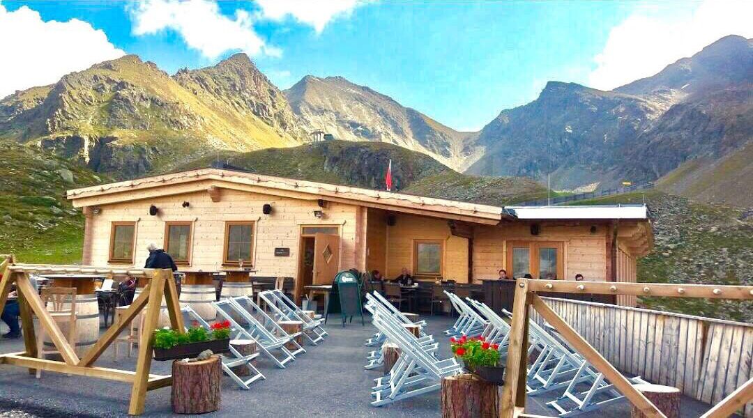
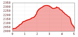
The trail starts opposite the Kühtai tourist information office, behind the Wiesberghaus. It gently climbs eastward to the Hirschebensee (2,164 m). From there, the ascent becomes a bit steeper but remains easy to walk. Passing the Mittlerer Plenderlessee (2,317 m), the path continues under the chairlift to the Drei-Seen-Hütte, which is a good spot for a rest. This tour involves a total ascent of just over 300 metres. The return follows the same path to the fork beneath the chairlift. From there, turn left and cross the usually damp meadows of the Wiesberg back to the starting point.

Nearby huts and mountain restaurants

More tours in the surrounding area

  • Wilder-Kaiser-Steig - Detour

    Difficulty: difficult
    Length: 33.0 km Duration: 16:49 h Elevation uphill: 2,311 m
  • Ötztal Trek Stage 6

    Difficulty: difficult
    Length: 7.6 km Duration: 3:30 h Elevation uphill: 640 m
  • Ötztal Trek Stage 3

    Difficulty: difficult
    Length: 10.4 km Duration: 4:00 h Elevation uphill: 842 m
  • Ötztal Trek Stage 7

    Difficulty: difficult
    Length: 5.3 km Duration: 2:00 h Elevation uphill: 376 m
  • Ötztal Trek Stage 1

    Difficulty: medium
    Length: 18.6 km Duration: 6:30 h Elevation uphill: 1,561 m
  • Ötztal Trek Stage 17

    Difficulty: difficult
    Length: 16.4 km Duration: 6:00 h Elevation uphill: 1,080 m
  • Ötztal Trek Stage 14

    Difficulty: difficult
    Length: 6.3 km Duration: 3:00 h Elevation uphill: 1,004 m
  • Ötztal Trek Stage 12

    Difficulty: difficult
    Length: 4.8 km Duration: 2:00 h Elevation uphill: 592 m
  • Ötztaler Urweg

    Length: 189.1 km Duration: 72:19 h Elevation uphill: 9,428 m
  • Ötztal Trek Stage 4

    Difficulty: difficult
    Length: 8.9 km Duration: 4:00 h Elevation uphill: 802 m
  • Ötztal Trek Stage 2

    Difficulty: difficult
    Length: 10.7 km Duration: 4:00 h Elevation uphill: 926 m
  • Ötztal Trek Stage 9

    Difficulty: difficult
    Length: 12.8 km Duration: 6:00 h Elevation uphill: 1,623 m
  • Ötztal Trek Stage 10

    Difficulty: difficult
    Length: 11.1 km Duration: 4:30 h Elevation uphill: 1,476 m
  • Ötztal Trek Stage 15

    Difficulty: difficult
    Length: 6.5 km Duration: 2:30 h Elevation uphill: 332 m
  • Ötztal Trek Stage 16

    Difficulty: difficult
    Length: 6.9 km Duration: 2:30 h Elevation uphill: 358 m
  • Ötztal Trek Stage 19

    Difficulty: difficult
    Length: 11.0 km Duration: 5:00 h Elevation uphill: 1,246 m
  • Ötztal Trek Stage 13

    Opening hours: closed
    Difficulty: difficult
    Length: 8.5 km Duration: 3:30 h Elevation uphill: 390 m
  • Ötztal Trek Stage 11

    Difficulty: difficult
    Length: 12.0 km Duration: 5:00 h Elevation uphill: 705 m
Newsletter

The mountain is calling? So does our newsletter!

In our monthly newsletter we reveal the best holiday tips for Tyrol.