Mountain hikes Lechleiten zur Mindelheimerhütte

Difficulty ratings: difficult
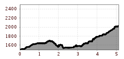
Route length: 5.1 km

Wonderful hike crossing the Austrian/German border with many highlights on the tour.
Tour information

  • Requirement: difficult
  • Length: 5.1 km
  • Elevation uphill:1,003 hm
  • Elevation downhill:477 hm
Highest point2,029 m

Starting point

Lechleiten

Finishing point

Mindelheimer Hütte
  • Fitness level 4 / 6
  • Technique 5 / 6

Best time of year

  • January
  • February
  • March
  • April
  • May
  • June
  • July
  • August
  • September
  • October
  • November
  • December

Trail condition

Wandersteig

Equipment

Eine gute Ausrüstung ist für Ihre Wanderung unverzichtbar. Folgende Gegenstände gehören somit auf jeden Fall in Ihren Rucksack: • Proviant und Getränk • Funktionelle Bekleidung für Regen, Wind und Kälte • Kleidung zum Wechseln • Sonnenschutz • Erste-Hilfe-Set • Mobiltelefon mit vollem Akku (Euro Notruf 112) • Wanderkarte oder GPS • Wanderstöcke Dennoch gilt: leichtes Gepäck trägt sich auch besser, deshalb sollten Sie ihren Rucksack nicht mit unnötigem Ballast beschweren. Darüber hinaus soll Ihre Wanderausrüstung natürlich auch Ihrer jeweiligen Wandertour entsprechend angepasst sein.
Source: TVB Lechtal

Description

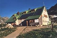
The refuge is run by the German Alpine Club Mindelheim section. The ascent to the hut can be made from several valley villages. From the south, you can reach the Mindelheimer Hütte from Lechleiten via the Schrofenpass. From the Schrofenpass, the route becomes a little more challenging, crossing a rock via a steel ladder. IMPORTANT Mountain experience and a head for heights are required here. 120 campsites and 20 places in the winter room.

Nearby huts and mountain restaurants

More tours in the surrounding area

Newsletter

The mountain is calling? So does our newsletter!

In our monthly newsletter we reveal the best holiday tips for Tyrol.