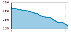
Open interactive mapOpen this POI on the interactive mapElevation profiledownloadOn the Trail of Gold.gpx
Kotalm Mitterleger - dahinter die mächtigen Klobenjoch Wände © Achensee Tourismus Achenkirch - Köglalm - Kotalm Mitterleger - Kotalm Niederleger – AchenkirchDifficulty:mediumLength:9.6 kmDuration:5:00 hElevation uphill:720 mSee trailSee trail: Achenkirch - Köglalm - Kotalm Mitterleger - Kotalm Niederleger – Achenkirch
die Gufferthütte - sie gehört der Deutschen Alpenvereinssektion Mühldorf a. Inn © Achensee Tourismus Achenkirch - Geopfad Obere Ampelsbach- und Filzmoosbach Schlucht - Gufferthütte - AchenkirchDifficulty:mediumLength:15.2 kmDuration:4:30 hElevation uphill:490 mSee trailSee trail: Achenkirch - Geopfad Obere Ampelsbach- und Filzmoosbach Schlucht - Gufferthütte - Achenkirch
imst_tourismus_rosengartenschlucht_wyhlidal_west_0009.jpg © Rudi Wyhlidal / WEST - Kollreider RosengartenschluchtOpening hours:openDifficulty:easyLength:4.4 kmDuration:2:30 hElevation uphill:282 mSee trailSee trail: Rosengartenschlucht
Elbigenalp Gibler AlmDifficulty:easyLength:1.4 kmElevation uphill:153 mSee trailSee trail: Elbigenalp Gibler Alm
Feldberg, Stripsenjoch, Kaiserbachtal, Region St. Johann in Tirol, Kirchdorf © Mirja Geh Kaiserbachtal - Feldberg - StripsenjochDifficulty:mediumLength:21.0 kmDuration:9:00 hElevation uphill:1,170 mSee trailSee trail: Kaiserbachtal - Feldberg - Stripsenjoch
Hoch oben an der Rastkogelhütte © Archiv TVB Mayrhofen Circuit & summit hike: Schwendberg (Jausenstation Melchboden) Arbiskopf, Rauhenkopf and KreuzjochDifficulty:mediumLength:8.6 kmDuration:3:30 hElevation uphill:450 mSee trailSee trail: Circuit & summit hike: Schwendberg (Jausenstation Melchboden) Arbiskopf, Rauhenkopf and Kreuzjoch
neuer-wanderweg-im-stilluptal-foto-stefan-absenger © Archiv TVB Mayrhofen Themed hike: Stilluptal "Wasserfallweg"Difficulty:easyLength:15.3 kmDuration:5:00 hElevation uphill:325 mSee trailSee trail: Themed hike: Stilluptal "Wasserfallweg"
Klang des Holzes © © Serfaus-Fiss-Ladis Marketing GmbH Six Senses trailOpening hours:openDifficulty:easyLength:6.5 kmDuration:4:00 hElevation uphill:99 mSee trailSee trail: Six Senses trail
Alpine hike to Lienzer HütteDifficulty:easyLength:6.8 kmDuration:2:30 hElevation uphill:297 mSee trailSee trail: Alpine hike to Lienzer Hütte
outdooractiveImport_25033503 © TVB Stubai Stubai Tree House TrailDifficulty:easyLength:6.0 kmDuration:2:00 hElevation uphill:44 mSee trailSee trail: Stubai Tree House Trail
Stage 2: Franz-Senn-Hut – Neue Regensburger HutDifficulty:difficultLength:9.0 kmDuration:4:00 hElevation uphill:603 mSee trailSee trail: Stage 2: Franz-Senn-Hut – Neue Regensburger Hut
Pärchen nähe Falbesoner Ochsenalm © TVB Stubai Falbeson - Falbesoner Ochsenalm - Neue Regensburger HütteDifficulty:mediumLength:4.1 kmDuration:3:39 hElevation uphill:1,151 mSee trailSee trail: Falbeson - Falbesoner Ochsenalm - Neue Regensburger Hütte
swiss-track02-c-npht-martin-kurzthaler.jpeg © Nationalpark Hohe Tauern / Martin Kurzthaler Rollitour with Swiss TracDifficulty:easyLength:3.2 kmDuration:1:30 hElevation uphill:135 mSee trailSee trail: Rollitour with Swiss Trac
imagemeta.apiv2.1593523029518 © TVB Stubai Sulzenau Hütte - Blaue Lacke und GrünauseeDifficulty:mediumLength:3.2 kmDuration:1:07 hElevation uphill:117 mSee trailSee trail: Sulzenau Hütte - Blaue Lacke und Grünausee
Kaiserjochhaus © Lechtal Tourismus Lechtaler Höhenweg: 3. Etappe Kasierjochhaus-Ansbacher HütteDifficulty:difficultLength:11.3 kmDuration:6:45 hElevation uphill:1,010 mSee trailSee trail: Lechtaler Höhenweg: 3. Etappe Kasierjochhaus-Ansbacher Hütte
Lech bei Forchach. © Lechtal Tourismus Stanzach - Over the suspension bridgeDifficulty:easyLength:12.8 kmDuration:3:15 hElevation uphill:42 mSee trailSee trail: Stanzach - Over the suspension bridge
Wildschönau Auffach Schatzberg Familienwanderung.jpg © Wildschönau Tourismus Johannes Sautner Rechte Skijuwel und Wildschönau Schatzberg and Joel SpitzeDifficulty:mediumLength:7.3 kmDuration:3:00 hElevation uphill:400 mSee trailSee trail: Schatzberg and Joel Spitze
iseltrail-hangebruecke-mai-2024-c-peter-maier-183_TVB Osttirol_Peter Maier_Virgen in Osttirol.jpg © Peter Maier Circular hike suspension bridge Isel Canyon via "Hohe Bank"Difficulty:mediumLength:8.1 kmDuration:2:50 hElevation uphill:300 mSee trailSee trail: Circular hike suspension bridge Isel Canyon via "Hohe Bank"
Tux: Circular Hike Weitental over Tuxer Joch in HintertuxDifficulty:mediumLength:9.0 kmDuration:3:30 hElevation uphill:300 mSee trailSee trail: Tux: Circular Hike Weitental over Tuxer Joch in Hintertux
Kreuz-Tragender © Rupert Gapp High Trail StanzerwaalDifficulty:mediumLength:10.5 kmDuration:3:30 hElevation uphill:320 mSee trailSee trail: High Trail Stanzerwaal
Steinsee 2.232m © TVB TirolWest Alfutzalm - SteinseehütteDifficulty:mediumLength:4.8 kmDuration:3:24 hElevation uphill:814 mSee trailSee trail: Alfutzalm - Steinseehütte
Hundalmjoch © Ferienregion Hohe Salve Hike to the HundalmjochDifficulty:mediumDuration:7:00 hElevation uphill:993 mSee trailSee trail: Hike to the Hundalmjoch
Schwarzachtal - Nr. 8Difficulty:easyLength:2.0 kmDuration:1:50 hElevation uphill:172 mSee trailSee trail: Schwarzachtal - Nr. 8
Grüblspitze - TorseenDifficulty:mediumLength:13.0 kmDuration:5:30 hElevation uphill:620 mSee trailSee trail: Grüblspitze - Torseen
Arbiskogel - KirchspitzeDifficulty:difficultLength:17.0 kmDuration:7:15 hElevation uphill:1,616 mSee trailSee trail: Arbiskogel - Kirchspitze
Give feedback for a chance to win a special holiday experience!Click here for the surveyClick here for the survey