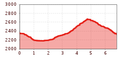
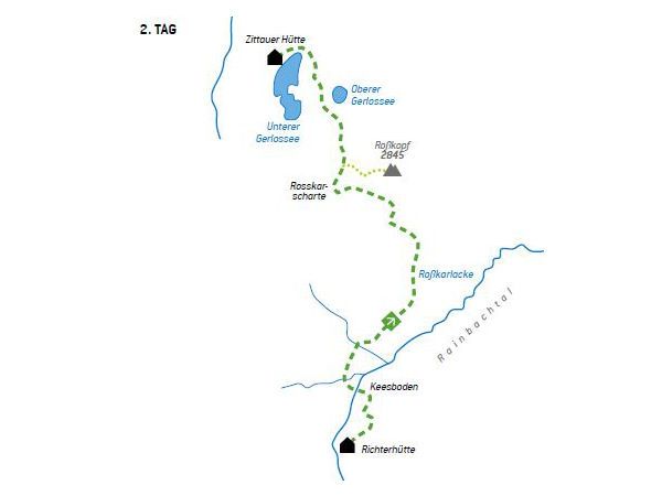
Open interactive mapOpen this POI on the interactive mapElevation profileWöffi Tour 16 / Tag 2: Von den Zillertaler Alpen in die Hohen Tauern.gpx
Herrlicher Ausblick © Lechtal Tourismus PanoramawegDifficulty:mediumLength:6.6 kmDuration:3:00 hElevation uphill:475 mSee trailSee trail: Panoramaweg
Hermann v. Barth Hütte © Lechtal Tourismus Elbigenalp - Hermann v. Barth HütteDifficulty:mediumLength:6.3 kmDuration:3:50 hElevation uphill:1,062 mSee trailSee trail: Elbigenalp - Hermann v. Barth Hütte
Evening winter hike Kleinmutzkopf, NaudersDifficulty:easyLength:6.0 kmDuration:2:00 hElevation uphill:70 mGo to winter hikeGo to winter hike: Evening winter hike Kleinmutzkopf, Nauders
Putzen-Alm © TVB St. Anton am Arlberg Patrick Bätz St. Anton - PutzenalpeOpening hours:closedDifficulty:mediumLength:10.8 kmDuration:4:00 hElevation uphill:605 mSee trailSee trail: St. Anton - Putzenalpe
KarwendeltourDifficulty:mediumLength:42.1 kmDuration:14:00 hElevation uphill:1,924 mSee trailSee trail: Karwendeltour
Besinnungsweg © Lechtal Tourismus Hölltal - Trail of the Senses - Bschlaber HöhenwegDifficulty:mediumLength:7.4 kmDuration:2:45 hElevation uphill:315 mSee trailSee trail: Hölltal - Trail of the Senses - Bschlaber Höhenweg
The WiegalmDifficulty:mediumLength:10.5 kmDuration:4:45 hElevation uphill:680 mSee trailSee trail: The Wiegalm
Winter walk Schwarzer See, NaudersDifficulty:easyLength:10.5 kmDuration:3:30 hElevation uphill:255 mGo to winter hikeGo to winter hike: Winter walk Schwarzer See, Nauders
Rundwanderung um den PlanseeDifficulty:mediumLength:14.6 kmDuration:3:30 hElevation uphill:85 mSee trailSee trail: Rundwanderung um den Plansee
Sillianer Hütte © Peter Leiter Carnic altitude trail. Stage 1: Arnbach - Sillianer HütteDifficulty:easyLength:9.5 kmElevation uphill:1,350 mSee trailSee trail: Carnic altitude trail. Stage 1: Arnbach - Sillianer Hütte
Sillianer Hütte © TVBOsttirol Carnic altitude trail. Stage 2: Sillianer Hütte- Obstansersee HütteDifficulty:mediumLength:8.7 kmElevation uphill:503 mSee trailSee trail: Carnic altitude trail. Stage 2: Sillianer Hütte- Obstansersee Hütte
Mountain station Spieljochbahn - Hochfügen Difficulty:mediumLength:12.2 kmDuration:4:00 hElevation uphill:270 mSee trailSee trail: Mountain station Spieljochbahn - Hochfügen
Sonnenaufgang_Kleiner_Gilfert_©FranzKupfner.jpg © (c) Ferienregion Fügen-Kaltenbach im Zillertal, Franz Kupfner Hochfügen - Kleiner Gilfert (2388m) Walk no. 27Difficulty:mediumLength:14.4 kmDuration:6:00 hElevation uphill:925 mSee trailSee trail: Hochfügen - Kleiner Gilfert (2388m) Walk no. 27
Zillertal, Kaltenbach, Wedelhütte_Tirol Werbung_Bauer Frank_Kaltenbach © Tirol Werbung | Frank Bauer Mountain Hike to the WedelhütteDifficulty:mediumLength:3.0 kmDuration:3:00 hElevation uphill:490 mSee trailSee trail: Mountain Hike to the Wedelhütte
Württemberger Haus 2.220m © Roman Huber Zams - Württemberger HausDifficulty:mediumLength:10.1 kmDuration:11:20 hElevation uphill:1,554 mSee trailSee trail: Zams - Württemberger Haus
Kreuzwiese_c8e91882528c18c36b38216f9f5e6705 © Kreuzwiesenalm Foodie TrailDifficulty:easyLength:3.0 kmDuration:1:39 hElevation uphill:210 mSee trailSee trail: Foodie Trail
pilgrimage-church-maria-schnee-obermauern-nilbach-hoch-c-bernhard-assmair.jpg © Bernhard Aßmair Theme path "Virgen crossroads"Difficulty:easyLength:3.1 kmDuration:1:00 hElevation uphill:90 mSee trailSee trail: Theme path "Virgen crossroads"
2019_best-of-zillertal_image_stummerberg_bike-and-hike_level26_web_20 (1).jpg © (c) Ferienregion Fügen-Kaltenbach im Zillertal, level26 Hamberg (2095m) from the Gasthof Almluft (Trail No. 37)Difficulty:mediumLength:9.4 kmDuration:4:45 hElevation uphill:865 mSee trailSee trail: Hamberg (2095m) from the Gasthof Almluft (Trail No. 37)
Europakreuz auf der Gr. Kinigat © A. Goller Carnic altitude trail. Stage 3: Obstansersee Hütte – PorzehütteDifficulty:mediumLength:11.3 kmDuration:6:00 hElevation uphill:650 mSee trailSee trail: Carnic altitude trail. Stage 3: Obstansersee Hütte – Porzehütte
Der Murmliweg in Serfaus © © Serfaus-Fiss-Ladis Marketing GmbH Marmot TrailOpening hours:closedDifficulty:easyLength:573 mDuration:0:20 hElevation uphill:12 mSee trailSee trail: Marmot Trail
Axamer Lizum to Halsl and then on to Saile/NockspitzeDifficulty:mediumLength:9.4 kmDuration:5:00 hElevation uphill:886 mSee trailSee trail: Axamer Lizum to Halsl and then on to Saile/Nockspitze
Winter- und Schneeschuhwandern (c) Mirja Geh (26).jpg © Mirja Geh At the foot of Fleischbank and TotenkirchlDifficulty:easyLength:9.3 kmDuration:3:00 hElevation uphill:250 mGo to winter hikeGo to winter hike: At the foot of Fleischbank and Totenkirchl
The Zirbenweg trailDifficulty:easyLength:7.0 kmDuration:2:30 hElevation uphill:200 mSee trailSee trail: The Zirbenweg trail
Suspension bridge to Maria Locherboden pilgrimage churchDifficulty:mediumLength:8.5 kmDuration:3:00 hElevation uphill:370 mSee trailSee trail: Suspension bridge to Maria Locherboden pilgrimage church
St. Sigmund - Pforzheimer Hütte mountain hut (145)Difficulty:mediumLength:14.1 kmDuration:5:00 hElevation uphill:781 mSee trailSee trail: St. Sigmund - Pforzheimer Hütte mountain hut (145)
Give feedback for a chance to win a special holiday experience!Click here for the surveyClick here for the survey


.jpg")


.jpg")


Manfred Pfister.jpg")


.jpg")


 Mirja Geh (26).jpg")


