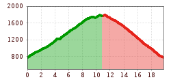
Open interactive mapOpen this POI on the interactive mapElevation profileOn Tour with Benni Raich - Gravel Bike.gpx
Alpbachtal Hüttenjause auf der Farmkehralm © Mathäus Gartner 3-day Family Tour AlpbachtalDifficulty:easyLength:18.3 kmDuration:7:00 hElevation uphill:998 mSee trailSee trail: 3-day Family Tour Alpbachtal
web-wilder-kaiser-bergdoktorpraxis-ellmaul-sommer2022-mathaeusgartner-2©mathaeusgartner © Mathäus Gartner Wilder Kaiser cycle route no. 14Difficulty:mediumLength:38.3 kmElevation uphill:520 mGo to biketourGo to biketour: Wilder Kaiser cycle route no. 14
Tour of the Alps © Hannes Sautner Alpbachtal GiroDifficulty:difficultLength:117.4 kmDuration:5:45 hElevation uphill:2,250 mGo to biketourGo to biketour: Alpbachtal Giro
Zireiner See © Gabriele Grießenböck Lake Zirein via SonnwendjochberghausDifficulty:difficultLength:18.4 kmDuration:6:15 hElevation uphill:894 mSee trailSee trail: Lake Zirein via Sonnwendjochberghaus
Gipfelkreuz Voldöpper Spitze © Sandrine Stock Voldöpper Spitze Loop HikeDifficulty:mediumLength:12.9 kmDuration:5:00 hElevation uphill:988 mSee trailSee trail: Voldöpper Spitze Loop Hike
Wasserspiele im Juppi Zauberwald © Ski Juwel Alpbachtal Wildschönau Loop tour Juppi ZauberwaldDifficulty:easyLength:2.5 kmDuration:1:00 hElevation uphill:93 mSee trailSee trail: Loop tour Juppi Zauberwald
S-B4 Silvretta High-Altitude Trail LargeOpening hours:closedDifficulty:mediumLength:4.0 kmDuration:1:00 hElevation uphill:61 m:Style: ClassicGo to Cross-country skiing trailGo to Cross-country skiing trail: S-B4 Silvretta High-Altitude Trail Large
Kundler Klamm Familie © Shootandstyle Kundler KlammOpening hours:closedDifficulty:easyLength:6.4 kmDuration:2:00 hElevation uphill:116 mSee trailSee trail: Kundler Klamm
Familienausflug in den Hildegard-von-Bingen-Garten in Reith i.A. © shootandstyle Barrier free Hildegard von Bingen pathDifficulty:easyLength:3.1 kmDuration:1:30 hElevation uphill:43 mSee trailSee trail: Barrier free Hildegard von Bingen path
Tiroler SilberpfadDifficulty:easyLength:88.0 kmDuration:32:00 hElevation uphill:3,500 mSee trailSee trail: Tiroler Silberpfad
S-B1 Dam Trail Silvretta BielerhöheOpening hours:closedDifficulty:easyLength:2.0 kmDuration:0:35 hElevation uphill:82 m:Style: ClassicGo to Cross-country skiing trailGo to Cross-country skiing trail: S-B1 Dam Trail Silvretta Bielerhöhe
Langlaufen Angerberg @Überall (77).jpg © Überall Cross-country skiing centre Angerberg - easy training trailOpening hours:closedDifficulty:easyLength:1.1 kmElevation uphill:10 m:Style: ClassicGo to Cross-country skiing trailGo to Cross-country skiing trail: Cross-country skiing centre Angerberg - easy training trail
Alpbachtal Hüttenjause auf der Farmkehralm © Mathäus Gartner Farmkehralm 1.521 mDifficulty:mediumLength:9.3 kmDuration:3:30 hElevation uphill:506 mSee trailSee trail: Farmkehralm 1.521 m
Barrierefreier Weg am Reintalersee in Kramsach Ferienregion Alpbachtal © shootandstyle Barrier-free path Lake ReintalDifficulty:easyLength:6.5 kmDuration:1:45 hElevation uphill:15 mSee trailSee trail: Barrier-free path Lake Reintal
Kaiserklamm Tunnel © Alpbachtal Tourismus Kaiser Gorge - loop trailOpening hours:closedDifficulty:easyLength:4.2 kmDuration:1:00 hElevation uphill:198 mSee trailSee trail: Kaiser Gorge - loop trail
Panoramaweg Wiedersbergerhorn Alpbach © Gabriele Grießenböck Wiedersberger Horn Panorama PathDifficulty:easyLength:4.1 kmDuration:1:30 hElevation uphill:195 mSee trailSee trail: Wiedersberger Horn Panorama Path
Dorfrunde - Langlauf in Oberndorf, Region St. Johann in Tirol © www.MirjaGeh.com Dorfrunde St. JohannOpening hours:closedDifficulty:easyLength:1.2 kmDuration:0:18 h:Style: ClassicGo to Cross-country skiing trailGo to Cross-country skiing trail: Dorfrunde St. Johann
Aussichtsplattform Tiefenbachklamm © Hannes Sautner Shootandstyle Discovering the Tiefenbach Gorge HikeOpening hours:closedDifficulty:mediumLength:5.7 kmDuration:3:30 hElevation uphill:669 mSee trailSee trail: Discovering the Tiefenbach Gorge Hike
Europakreuz auf der Gr. Kinigat © A. Goller Carnic altitude trail. Stage 3: Obstansersee Hütte – PorzehütteDifficulty:mediumLength:11.3 kmDuration:6:00 hElevation uphill:650 mSee trailSee trail: Carnic altitude trail. Stage 3: Obstansersee Hütte – Porzehütte
Langlaufen im Defereggental - Oberseeloipe © TVB Osttirol / Peter Maier Cross-country ski run "Obersee"Opening hours:openDifficulty:mediumLength:4.5 kmElevation uphill:41 m:Style: ClassicGo to Cross-country skiing trailGo to Cross-country skiing trail: Cross-country ski run "Obersee"
Höhenloipe Dorfberg © Tirol Werbung/Reiter Philipp Dorfberg altitude slopeOpening hours:openDifficulty:mediumLength:10.0 kmElevation uphill:250 m:Style: ClassicGo to Cross-country skiing trailGo to Cross-country skiing trail: Dorfberg altitude slope
2019_best-of-zillertal_image_stummerberg_bike-and-hike_level26_web_20 (1).jpg © (c) Ferienregion Fügen-Kaltenbach im Zillertal, level26 Hamberg (2095m) from the Gasthof Almluft (Trail No. 37)Difficulty:mediumLength:9.4 kmDuration:4:45 hElevation uphill:865 mSee trailSee trail: Hamberg (2095m) from the Gasthof Almluft (Trail No. 37)
Sillianer Hütte © TVBOsttirol Carnic altitude trail. Stage 2: Sillianer Hütte- Obstansersee HütteDifficulty:mediumLength:8.7 kmElevation uphill:503 mSee trailSee trail: Carnic altitude trail. Stage 2: Sillianer Hütte- Obstansersee Hütte
wallfahrtskirche-maria-schnee-obermauern-nilbach-hoch-c-bernhard-assmair.jpg © Bernhard Aßmair Theme path "Virgen crossroads"Difficulty:easyLength:3.2 kmDuration:1:00 hElevation uphill:104 mSee trailSee trail: Theme path "Virgen crossroads"
Mountain station Spieljochbahn - Hochfügen Difficulty:mediumLength:12.2 kmDuration:4:00 hElevation uphill:270 mSee trailSee trail: Mountain station Spieljochbahn - Hochfügen
Give feedback for a chance to win a special holiday experience!Click here for the surveyClick here for the survey


.jpg")


.jpg")
.jpg")


.jpg")


Manfred Pfister.jpg")
