Mountain hikes Feistenau – Karspitze – Wandberg Circular Hike

Rettenbach / Chiemgau Alps
Difficulty ratings: medium
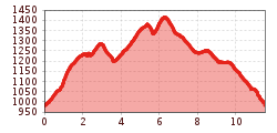
Route length: 11.0 km
Duration: 3:45 h

Trail . Nr.: 14, 47a

Tour information

  • Requirement: medium
  • Length: 11.0 km
  • Duration: 3:45 h
  • Elevation uphill:500 hm
  • Elevation downhill:500 hm
Highest point1,454 m

Starting point

Parking Lot Faistenau

Finishing point

Parking lot Faistenau

Features

  • Circular route
  • Suitable for families

Best time of year

  • January
  • February
  • March
  • April
  • May
  • June
  • July
  • August
  • September
  • October
  • November
  • December

Trail condition

Forest Road, Hiking Trail

Equipment

Breathable outdoor clothing suitable for the weather, sturdy footwear, food (snacks, drinks),
sun protection (sunglasses, sun cream & cap), rain protection, cash; guest card if using the bus
Source: TVB Kaiserwinkl

Description

You start the hike at the Feistenau parking lot. Immediately after the Schöne Aussicht inn, the signs point you toward Karspitze. From there, you can already enjoy a panoramic view of up to 50 kilometers. The trail leads you back down to the Rettenbachalmen. Follow the public alpine trail for about 1 kilometer until you reach a fork in the trail. The path on the right takes you briefly through the forest until you reach the south side of the Wandberg. After about 30 minutes, you’ll be on the Wandberg. After a short descent, the Burgeralm and the Wandberghütte invite you to stop for a break. For the return trip, follow the public alpine trail for about 1 hour and 15 minutes until you’re back at the starting point.

Nearby huts and mountain restaurants

Getting here

Weather

Today

clear sky
24°C/12°C
35%1.1l5 km/h

Tue

light rain showers
22°C/13°C
80%7.5l5 km/h

Wed

mainly clear
26°C/13°C
25%0.2l5 km/h
Go to weather forecast

More tours in the surrounding area

Newsletter

The mountain is calling? So does our newsletter!

In our monthly newsletter we reveal the best holiday tips for Tyrol.