Mountain hikes Fleiding

Brixen im Thale / Kitzbühel Alps
Difficulty ratings: medium
Route length: 3.3 km
Duration: 1:15 h

Panoramic tour with summit victory!
Tour information

  • Requirement: medium
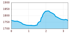
  • Length: 3.3 km
  • Duration: 1:15 h
  • Elevation uphill:180 hm
  • Elevation downhill:180 hm
Highest point1,892 m

Starting point

Bergstation Alpenrosenbahn

Finishing point

Bergstation Alpenrosenbahn
  • Fitness level 3 / 6
  • Technique 3 / 6

Features

  • Circular route
  • Suitable for families

Best time of year

  • January
  • February
  • March
  • April
  • May
  • June
  • July
  • August
  • September
  • October
  • November
  • December

Trail condition

mountain trail, gravel road

Equipment

hiking shoes, weather protection, food, drink, first aid kit
Source: Kitzbüheler Alpen Management GmbH

Description

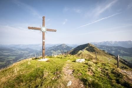
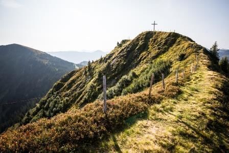
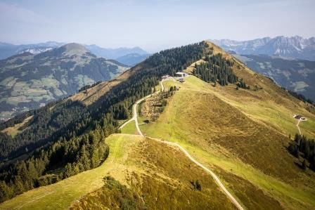
From the Alpenrosenbahn’s mountain-top station, we head off to the right along the road for about 200m downhill as far as the signpost for Höhningscharte. There we branch off to the left follow the upper trail towards Kreuzjöchl Lake. After a small ascent, please take note of the signpost to the Fleidinggipfel! The wide hiking trail reduces to a narrow hiking trail at the lift station which leads us steadily uphill to the summit. There a beautiful summit cross awaits us, which is looked after by Westendorf’s mountain rescue service. For the descent we follow the flat tractor trail to the left of the cross, which later leads over a rather steep Alpine meadow down to the Höhningscharte.  From there we hike the well-known path back to the mountain-top gondola station.
Info: If you keep to the left at the Höhningscharte and walk along the road, you will reach the "Schrandlhof" after numerous serpentine bends and later Westendorf’s village centre (approx. 13 km).  The route via the Alpenrosensteig to the middle station is also recommended.


Nearby huts and mountain restaurants

Getting here

Weather

Today

light rain showers
24°C/11°C
90%27.8l5 km/h

Thu

light rain showers
18°C/10°C
70%1.7l5 km/h

Fri

light rain
18°C/9°C
60%4.8l5 km/h
Go to weather forecast

More tours in the surrounding area

  • The Wiegalm

    Difficulty:medium
    Length:10.5 kmDuration:4:45 hElevation uphill:680 m
  • Koasa Trail Stage 2

    Difficulty:medium
    Length:11.8 kmDuration:7:15 hElevation uphill:1,078 m
  • Eifersbacher Wasserfall

    Difficulty:medium
    Length:5.9 kmDuration:2:30 hElevation uphill:241 m
  • Koasa Trail Stage 3

    Difficulty:medium
    Length:19.9 kmDuration:7:10 hElevation uphill:730 m
  • Koasa Trail Stage 5

    Difficulty:medium
    Length:14.0 kmDuration:6:45 hElevation uphill:935 m
  • Kaiserkrone - stage 5

    Difficulty:medium
    Length:10.8 kmDuration:5:15 hElevation uphill:840 m
  • Kaiserkrone - stage 4

    Difficulty:medium
    Length:16.1 kmDuration:6:30 hElevation uphill:640 m
  • Koasa Trail Stage 1

    Difficulty:medium
    Length:16.9 kmDuration:6:45 hElevation uphill:937 m
  • Koasa Trail Stage 4

    Difficulty:medium
    Length:20.6 kmDuration:7:35 hElevation uphill:923 m
  • Möslalmkogel via Wörgl

    Difficulty:medium
    Length:10.3 kmDuration:3:30 hElevation uphill:580 m
  • Schafsiedel

    Difficulty:medium
    Length:15.6 kmDuration:7:00 hElevation uphill:1,280 m
  • Bichlachrunde

    Difficulty:easy
    Length:10.5 kmDuration:3:30 hElevation uphill:295 m
  • Angerer Alm

    Difficulty:medium
    Length:5.7 kmDuration:2:45 hElevation uphill:652 m
  • Alpine Outdoor Gallery

    Difficulty:easy
    Length:6.7 kmDuration:2:00 hElevation uphill:117 m
Newsletter

The mountain is calling? So does our newsletter!

In our monthly newsletter we reveal the best holiday tips for Tyrol.