Mountain hikes Freizberg

Tösens / Ötztaler Alpen
Difficulty ratings: medium
Route length: 9.8 km
Duration: 6:10 h

Hike from  Steinbrucken in Tösens to Freitzberg in RIed im Oberinntal

Tour information

  • Requirement: medium
  • Length: 9.8 km
  • Duration: 6:10 h
  • Elevation uphill:928 hm
  • Elevation downhill:928 hm
Highest point1,490 m

Starting point

Steinbrücken | Tösens

Finishing point

Steinbrücken | Tösens
  • Fitness level 4 / 6
  • Technique 3 / 6

Best time of year

  • January
  • February
  • March
  • April
  • May
  • June
  • July
  • August
  • September
  • October
  • November
  • December

Trail condition

Trail

Equipment

We recommend equipment suitable for the tour and weather conditions, including sturdy shoes, weatherproof clothing, food, and appropriate maps.
Source: TVB Tiroler Oberland

Description

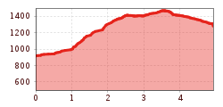
The starting point is in Tösens on the road near Steinbücken. From there follow the signs into the forest along the Lindachweg. At a turn-off, change to the Brandlsteig and follow the path towards Boden. From there, change to the Dr. Bernhard Steig and follow the signs towards Freizberg.

From Freizberg, walk back to Tösens on the same path.

Getting here

  • Arrival by public transport

    Line 210, Bus stop Tösens, walking distance to Steinbrücken: 2,2 km

More tours in the surrounding area

Newsletter

The mountain is calling? So does our newsletter!

In our monthly newsletter we reveal the best holiday tips for Tyrol.