Geo.Weg Achensee

Maurach am Achensee / Brandenberger Alpen (Rofan)
Difficulty ratings: easy
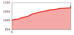
Route length: 1.0 km

Geo.Weg Achensee

Tour information

  • Requirement: easy
  • Length: 1.0 km
  • Elevation uphill:85 hm
Highest point1,085 m

Starting point

Maurach, oberhalb Rofangartenstraße Nr. 43 und 45

Finishing point

Maurach, Abzweigung Wanderweg zur Dalfaz Alm

Features

  • Suitable for families
  • suitable for pushchairs

Best time of year

  • January
  • February
  • March
  • April
  • May
  • June
  • July
  • August
  • September
  • October
  • November
  • December

Trail condition

gravel road

Equipment

Sturdy boots (ankle-high hiking boots), weather appropriate clothing. Telescopic hiking poles are recommended.
Source: Achensee

Getting here

  • Arrival by public transport

    Take the regional bus (line 4080 or 390; to reach the Rofan cable car also line 8332) to the Atoll Achensee leisure centre in Maurach. Get off at the bus stops Maurach a. A. Atoll Achensee or Maurach a. A. Rofan Seilbahn.

  • Parking

    Car park Atoll Achensee or Rofan Seilbahn (both paid parking lot)

More tours in the surrounding area

Newsletter

The mountain is calling? So does our newsletter!

In our monthly newsletter we reveal the best holiday tips for Tyrol.