Mountain hikes Hike from Jerzens to Wenns

Jerzens im Pitztal / Ötztal Alps
Difficulty ratings: easy
Route length: 3.9 km
Duration: 1:30 h

Hike from Jerzens to Wenns

Tour information

  • Requirement: easy
  • Length: 3.9 km
  • Duration: 1:30 h
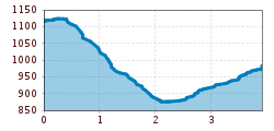
  • Elevation uphill:140 hm
  • Elevation downhill:260 hm
Highest point1,127 m

Starting point

bus stop Jerzens Dorf

Finishing point

Wenns

Best time of year

  • January
  • February
  • March
  • April
  • May
  • June
  • July
  • August
  • September
  • October
  • November
  • December

Trail condition

asphalt, forest path, track
Source: TVB Pitztal

Description

Starting point: Jerzens town centre. From the starting point, follow the path for approx. 300 m in the direction of Leins. Before the Hirschenklause B&B, turn downhill to the left to the hamlet of Pitzenhöfe. After the bridge follow the forest road on theleft in the direction to Wenns. Return to zour starting point via bus.  

Nearby huts and mountain restaurants

Weather

Today

light rain showers
21°C/13°C
65%5.1l5 km/h

Sun

light rain showers
17°C/10°C
75%7.8l5 km/h

Mon

clear sky
20°C/9°C
30%1.3l0 km/h
Go to weather forecast

More tours in the surrounding area

Newsletter

The mountain is calling? So does our newsletter!

In our monthly newsletter we reveal the best holiday tips for Tyrol.