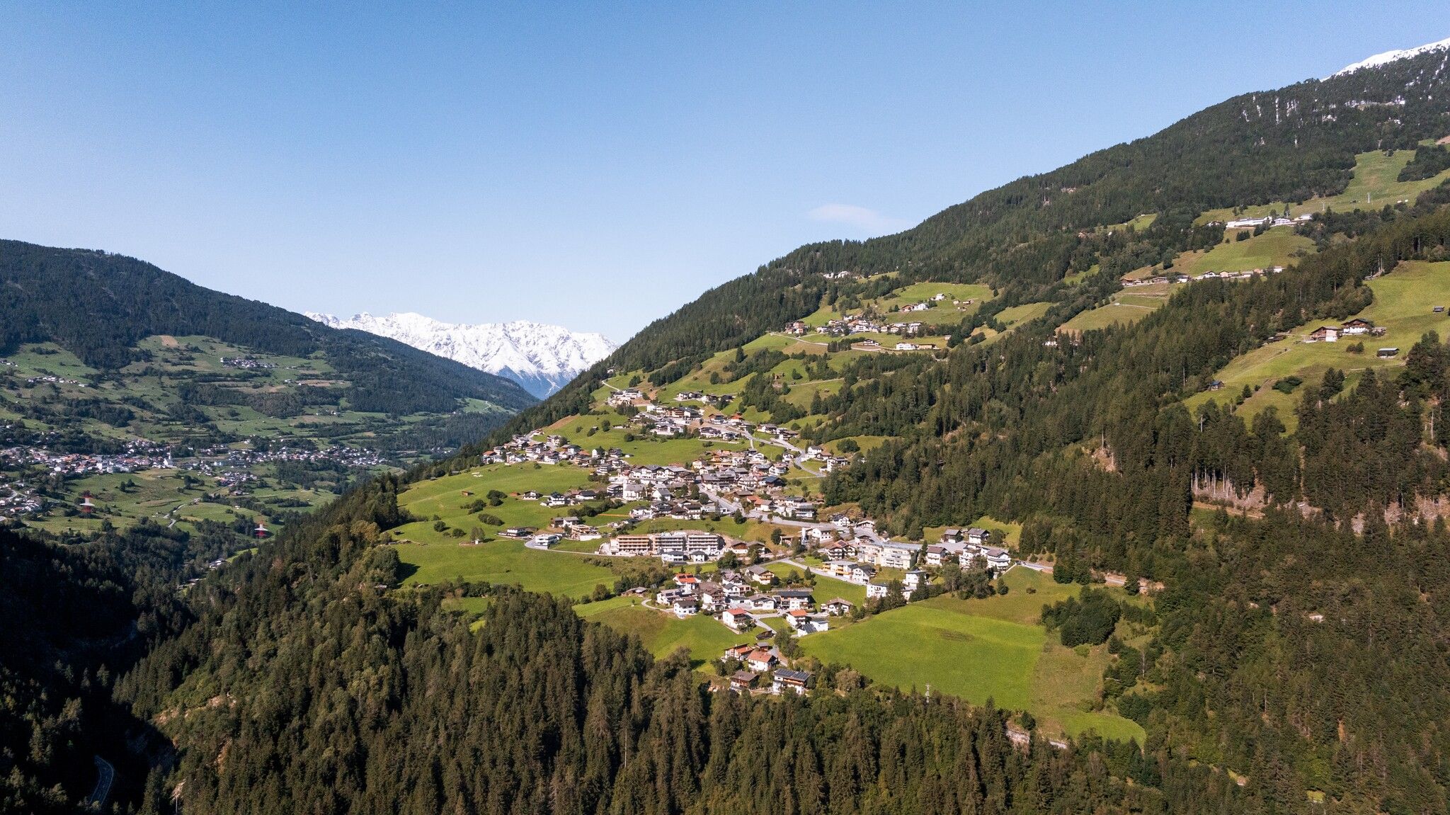
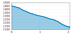
Open interactive mapOpen this POI on the interactive mapElevation profileDownloadHike from Liss to the centre of Jerzens.gpx
Hotel zum Lammwirt © Hotel zum Lammwirt Hotel zum LammwirtOpening hours:Open todayPlace:Jerzens:Restaurant, Tavernsee restaurant detailssee restaurant details: Hotel zum Lammwirt
Café Restaurant Zirm4 © Café Restaurant Zirm Café Restaurant Zirm JerzensOpening hours:Open todayPlace:Jerzens:Restaurant, cafésee restaurant detailssee restaurant details: Café Restaurant Zirm Jerzens
Pitzloch.JPG © Pitzloch Restaurant PitzlochOpening hours:Open todayPlace:Jerzens:Restaurant, cafésee restaurant detailssee restaurant details: Restaurant Pitzloch
Zirbenbaeckerei © HochzeigerBergbahnen_Pöham ZirbenBäckereiOpening hours:Open todayPlace:Jerzens:Restaurant, Snack bar / StreetFood, cafésee restaurant detailssee restaurant details: ZirbenBäckerei
Putzen-Alm © TVB St. Anton am Arlberg Patrick Bätz St. Anton - PutzenalpeDifficulty:mediumLength:10.8 kmDuration:4:00 hElevation uphill:605 mSee trailSee trail: St. Anton - Putzenalpe
Evening winter hike Kleinmutzkopf, NaudersDifficulty:easyLength:6.0 kmDuration:2:00 hElevation uphill:70 mGo to winter hikeGo to winter hike: Evening winter hike Kleinmutzkopf, Nauders
Muttereralm - Saile (Nockspitze)Difficulty:difficultLength:7.5 kmDuration:4:00 hElevation uphill:789 mSee trailSee trail: Muttereralm - Saile (Nockspitze)
GenießerRundWeg am Ahorn © Christian Lorenz Circular & themed hike: "GenießerRundWeg" at Mount AhornDifficulty:easyLength:2.0 kmDuration:0:45 hElevation uphill:70 mSee trailSee trail: Circular & themed hike: "GenießerRundWeg" at Mount Ahorn
Herrlicher Ausblick © Lechtal Tourismus PanoramawegDifficulty:mediumLength:6.6 kmDuration:3:00 hElevation uphill:470 mSee trailSee trail: Panoramaweg
Ackernalm Hütte Sommer © Gipfelfieber/Andreas Gruhle Up to Hinteres SonnwendjochDifficulty:mediumLength:10.9 kmElevation uphill:848 mSee trailSee trail: Up to Hinteres Sonnwendjoch
The WiegalmDifficulty:mediumLength:10.5 kmDuration:4:45 hElevation uphill:680 mSee trailSee trail: The Wiegalm
Winter walk Schwarzer See, NaudersDifficulty:easyLength:10.5 kmDuration:3:30 hElevation uphill:255 mGo to winter hikeGo to winter hike: Winter walk Schwarzer See, Nauders
large-Weg-der-Sinne-Pfafflar-5.jpg © Raimund Krabacher Hölltal - Trail of the Senses - Bschlaber HöhenwegDifficulty:mediumLength:7.4 kmDuration:2:45 hElevation uphill:315 mSee trailSee trail: Hölltal - Trail of the Senses - Bschlaber Höhenweg
Wandern Bettlersteig Kaistertal Naturerlebnis Kaisergebirge © Thomas Laukat Kaiserlift Tourentipp 5: From Brentenjoch into the Kaiser ValleyDifficulty:difficultLength:17.6 kmElevation uphill:425 mSee trailSee trail: Kaiserlift Tourentipp 5: From Brentenjoch into the Kaiser Valley
Rundwanderung um den PlanseeDifficulty:mediumLength:14.6 kmDuration:3:30 hElevation uphill:85 mSee trailSee trail: Rundwanderung um den Plansee
Hermann v. Barth Hütte © Lechtal Tourismus Elbigenalp - Hermann v. Barth HütteDifficulty:mediumLength:6.7 kmDuration:3:50 hElevation uphill:1,062 mSee trailSee trail: Elbigenalp - Hermann v. Barth Hütte
Horn-Gipfel-Höhenweg auf der Kitzbüheler Seite © Mirja Geh Kitzbüheler Horn via Horn-Gipfel-HöhenwegDifficulty:mediumLength:5.0 kmDuration:3:00 hElevation uphill:455 mSee trailSee trail: Kitzbüheler Horn via Horn-Gipfel-Höhenweg
sunnenseiten-weg-stubai-contwise-02.jpg © Andre Schönherr Sunnenseit'n Weg: Round tourDifficulty:mediumLength:8.2 kmDuration:3:00 hElevation uphill:400 mSee trailSee trail: Sunnenseit'n Weg: Round tour
Wanderung am Schlegeis mit Blick auf dem Stausee © Archiv TVB Mayrhofen Summit hike: Ginzling Schlegeis reservoir - Hoher RifflerDifficulty:difficultLength:17.0 kmDuration:7:30 hElevation uphill:1,500 mSee trailSee trail: Summit hike: Ginzling Schlegeis reservoir - Hoher Riffler
2018-Wandern-Bergsteigen-Tarrenz-Sinnesbrunn-Alpleskopf-web-©Rudi Wyhlidal (60).jpg © Rudi Wyhlidal / WEST - Kollreider falscher KogelDifficulty:difficultLength:1.7 kmDuration:2:30 hElevation uphill:364 mSee trailSee trail: falscher Kogel
Wildtierweg Fuchs.jpg © © Serfaus-Fiss-Ladis Marketing GmbH Wild Animals TrailOpening hours:openDifficulty:easySee trailSee trail: Wild Animals Trail
Leutkircher-Hütte © Lechtal Tourismus Lechtaler Höhenweg 1st stage: Stuttgarter Hütte-Leutkircher HütteDifficulty:difficultLength:6.6 kmDuration:3:15 hElevation uphill:469 mSee trailSee trail: Lechtaler Höhenweg 1st stage: Stuttgarter Hütte-Leutkircher Hütte
Hütte.jpg © (c) Serfaus-Fiss-Ladis Marketing GmbH_Andreas Kirschner Panorama - GenusswegOpening hours:openDifficulty:easyLength:1.1 kmDuration:1:15 hElevation uphill:282 mSee trailSee trail: Panorama - Genussweg
Round hike to Padauner KogelDifficulty:mediumLength:12.0 kmDuration:5:00 hElevation uphill:936 mSee trailSee trail: Round hike to Padauner Kogel
Geraerhütte_JohannesBitter_TVB-Wipptal_170623_105.jpg © JOHANNES BITTER Hike to the Geraer Hütte | Austrian TyrolDifficulty:mediumLength:7.0 kmDuration:5:30 hElevation uphill:1,000 mSee trailSee trail: Hike to the Geraer Hütte | Austrian Tyrol
valentinkapelle-1.jpg © Archiv TVB Mayrhofen Mountain hike: Zillergrund - Valentins KapelleDifficulty:mediumLength:3.2 kmDuration:2:30 hElevation uphill:390 mSee trailSee trail: Mountain hike: Zillergrund - Valentins Kapelle
Lämmerbichl_Tirol Werbung_Sürth Paul_Tux-Hintertux.jpg © Sürth Paul Spring with late crocus blossom in Tux ValleyDifficulty:mediumLength:10.0 kmDuration:4:00 hElevation uphill:640 mSee trailSee trail: Spring with late crocus blossom in Tux Valley
Barrierefreier Themenweg am Schlosskopf © Inn-Frame Fotografie www.inn-frame.at Barrier-free theme trail at the castle headDifficulty:easyLength:1.0 kmDuration:0:20 hElevation uphill:26 mSee trailSee trail: Barrier-free theme trail at the castle head
Kaiserbachtal (c) Sportalpen (21).jpg © ©Sportalpen Alpine Outdoor GalleryDifficulty:easyLength:6.7 kmDuration:2:00 hElevation uphill:117 mSee trailSee trail: Alpine Outdoor Gallery
Give feedback for a chance to win a special holiday experience!Click here for the surveyClick here for the survey


.jpg")
.jpg")


.jpg")


.jpg")


 Sportalpen (21).jpg")
