Arrival by public transport
Take the bus to the bus stop Jerzens Wiesle.
Experience a hike to the beautifully situated mountain lake, the Straßbergsee.

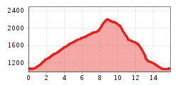
From the bus stop in Wiesle, walk approx. 500 metres out of the valley until a forest path branches off to the left. Past the Ritzenrieder Alm, at the end of the forest track, a path leads to the beautifully situated Straßbergsee lake. Once there, the path leads north-east to the Straßbergalm. The Ritzenrieder Alm and the Straßbergalm are managed by the same shepherd and are therefore open alternately. From the Straßbergalm, follow the signs to Graßlehn and from there continue along the road to the starting point.
Take the bus to the bus stop Jerzens Wiesle.
Free parking is available at the Außer Wiesle car park.