Long-distance hike: Berliner Höhenweg (Zillertal Runde)Difficulty:difficultLength:71.0 kmDuration:35:00 hElevation uphill:5,300 mSee trailSee trail: Long-distance hike: Berliner Höhenweg (Zillertal Runde)
Kitzbüheler Alpen_KATwalk2018-Etappe4_Erwin Haiden07.jpg © Erwin Haiden KAT WALK ALPINEDifficulty:mediumLength:113.0 kmDuration:45:00 hElevation uphill:6,300 mSee trailSee trail: KAT WALK ALPINE
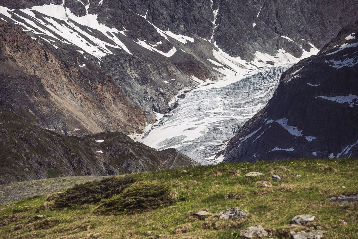
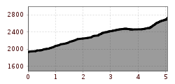
Weitwanderung Peter Habeler Runde © Archiv TVB Mayrhofen Long-distance hike: Peter Habeler RundeDifficulty:difficultLength:56.7 kmDuration:25:00 hElevation uphill:3,705 mSee trailSee trail: Long-distance hike: Peter Habeler Runde
Zireiner See Abendstimmung © Thomas Kargl 4 days - 4 summits tourDifficulty:mediumLength:54.4 kmDuration:23:00 hElevation uphill:3,408 mSee trailSee trail: 4 days - 4 summits tour
Mountain lakes and a panoramic peak in a class of its own Difficulty:mediumLength:23.9 kmDuration:11:30 hElevation uphill:2,188 mSee trailSee trail: Mountain lakes and a panoramic peak in a class of its own
Salve @Region Hohe Salve - Mathäus Gartner © @Region Hohe Salve - Mathäus Gartner KAT Walk: Three Valleys HikeDifficulty:mediumLength:69.0 kmDuration:30:00 hElevation uphill:3,684 mSee trailSee trail: KAT Walk: Three Valleys Hike
Wildseeloderhaus © Toni Niederwieser WaiWi - from Waidring to the WildseeloderDifficulty:mediumLength:50.0 kmDuration:24:00 hElevation uphill:3,200 mSee trailSee trail: WaiWi - from Waidring to the Wildseeloder
Heimkehrerkreuz © Peter Leiter Carnic altitude trailDifficulty:mediumLength:160.0 kmDuration:71:00 hElevation uphill:9,499 mSee trailSee trail: Carnic altitude trail
hochundheilig-etappe4-hollbruck-c-peter-maier.jpg © Peter Maier High and sacred – an Alpine pilgrim trail through East Tyrol, South Tyrol and Upper CarinthiaDifficulty:mediumLength:191.6 kmDuration:77:45 hElevation uphill:10,475 mSee trailSee trail: High and sacred – an Alpine pilgrim trail through East Tyrol, South Tyrol and Upper Carinthia
family_e2_brixen-kirchberg_c_erwin_haiden_18 © Kitzbühel | Erwin Haiden KAT WALK FAMILYDifficulty:mediumLength:52.5 kmElevation uphill:3,390 mSee trailSee trail: KAT WALK FAMILY
KAT-Walk2019@ErwinHaiden-7287 e2 logo natur.jpg © Erwin Haiden KAT WALK COMPACTDifficulty:mediumLength:83.0 kmDuration:36:45 hElevation uphill:5,462 mSee trailSee trail: KAT WALK COMPACT
Jakobsweg - Osttirol StagesDifficulty:mediumLength:67.7 kmDuration:21:00 hElevation uphill:1,765 mSee trailSee trail: Jakobsweg - Osttirol Stages
hoch-tirol-trail-abstieg-umbaltal-chl2322-c-geomarketing-christjanladurner.jpg © Geomarketing - Christjan Ladurner Hoch Tirol TrailDifficulty:difficultLength:28.9 kmDuration:12:30 hElevation uphill:1,519 mSee trailSee trail: Hoch Tirol Trail
hubertuskapelle-ströden-c-berny-steiner.jpg © Berny Steiner Pilgerweg Prägraten a.G.Difficulty:mediumLength:33.1 kmElevation uphill:2,793 mSee trailSee trail: Pilgerweg Prägraten a.G.
Ausblick von der Kapelle Maria Heimsuchung © Sportalpen Marketing EUREGIO-Maria-Weg-M5Difficulty:easyLength:166.6 kmDuration:46:16 hElevation uphill:2,971 mSee trailSee trail: EUREGIO-Maria-Weg-M5
Kufstein Stadtplatz Marienbrunnen © Lolin EUREGIO Marien-Weg-M6Difficulty:easyLength:12.1 kmDuration:3:38 hElevation uphill:268 mSee trailSee trail: EUREGIO Marien-Weg-M6
Lechtal, Lechtaler Höhenweg, Steinsee_Tirol Werbung_Schels Sebastian_No location given (4) © Tirol Werbung | Sebastian Schels Lechtaler HöhenwegDifficulty:difficultLength:84.5 kmDuration:45:00 hElevation uphill:6,773 mSee trailSee trail: Lechtaler Höhenweg
Lechtal Alps-Zams, Steinseehütte, from Hanauerhütte to Württemberger Haus, Adlerweg, stage 20_Tirol Werbung_Gigler Dominik_Zams (1).jpg © Gigler Dominik Eagle Walk TirolDifficulty:difficultLength:426.0 kmElevation uphill:30,000 mSee trailSee trail: Eagle Walk Tirol
Gogles Alm © Gogles Alm/Joachim E5 Konstanz - Oberstdorf - MeranDifficulty:difficultSee trailSee trail: E5 Konstanz - Oberstdorf - Meran
Kufstein Stadtplatz Marienbrunnen © Lolin EUREGIO-Marien-Weg-M3Difficulty:easyLength:179.0 kmDuration:52:17 hElevation uphill:3,190 mSee trailSee trail: EUREGIO-Marien-Weg-M3
Thierberg Kapelle Wandern © Sportalpen Marketing EUREGIO-Maria-Weg-M4Difficulty:easyLength:123.0 kmDuration:36:00 hElevation uphill:2,330 mSee trailSee trail: EUREGIO-Maria-Weg-M4
Wanderung Überschreitung Hohe Munde - Wanderer am Ostgipfel mit Blick auf das Inntal.jpg © Region Seefeld, Eva Beer Complete Route – Big 3 Multi-day Hike on Tirols HochplateauDifficulty:mediumLength:62.0 kmDuration:32:00 hElevation uphill:4,510 mSee trailSee trail: Complete Route – Big 3 Multi-day Hike on Tirols Hochplateau
The Tyrolean section of The Way of St. James through InnsbruckDifficulty:easyLength:81.4 kmDuration:21:00 hElevation uphill:900 mSee trailSee trail: The Tyrolean section of The Way of St. James through Innsbruck
Am Ponten auf über 2000 m. © grenzgaenger-wandern.com Grenzgänger - Hochalpiner Etappenwandersteig im AllgäuDifficulty:difficultLength:85.1 kmDuration:35:00 hElevation uphill:6,805 mSee trailSee trail: Grenzgänger - Hochalpiner Etappenwandersteig im Allgäu
Panorama Südseite_Wilder Kaiser © TVB Wilder Kaiser/Stefan Leitner 3-day hut tour Wilder KaiserDifficulty:difficultLength:24.6 kmDuration:14:00 hElevation uphill:2,060 mSee trailSee trail: 3-day hut tour Wilder Kaiser
Give feedback for a chance to win a special holiday experience!Click here for the surveyClick here for the survey
")


")
.jpg")


