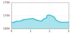
Open interactive mapOpen this POI on the interactive mapElevation profiledownloadMandarfner Runde klein.gpx
Benni-Raich-Brücke_0518_001.jpg © TVB Pitztal/Chris Walch Arzl - Benni-Raich-Bridge - WaldDifficulty:easyLength:1.8 kmDuration:0:40 hElevation uphill:120 mSee trailSee trail: Arzl - Benni-Raich-Bridge - Wald
Arzler Alm 1 © TVB Pitztal/Chris Walch Arzler Alm – TiefentalalmDifficulty:mediumLength:11.3 kmDuration:5:00 hElevation uphill:1,000 mSee trailSee trail: Arzler Alm – Tiefentalalm
Luibisalm, Luibisböden©StephanieSchlierenzauer (11).JPG © TVB Pitztal / Stephanie Schlierenzauer Panorama hike LuibisbödenDifficulty:mediumLength:7.4 kmDuration:4:15 hElevation uphill:890 mSee trailSee trail: Panorama hike Luibisböden
medium-der-speichersee-am-sechszeiger-hochzeiger-bergbahnen-3 © TVB Pitztal Panoramic tour Hochzeiger – Sechszeiger – Kalbenalm - Gondola top stationDifficulty:mediumLength:7.2 kmDuration:5:00 hElevation uphill:580 mSee trailSee trail: Panoramic tour Hochzeiger – Sechszeiger – Kalbenalm - Gondola top station
Benni-Raich-Brücke_0518_001.jpg © TVB Pitztal/Chris Walch Circular route Benni Raich bridge with Inn gorgeDifficulty:mediumLength:4.9 kmDuration:2:00 hElevation uphill:250 mSee trailSee trail: Circular route Benni Raich bridge with Inn gorge
Ludwigsburger Hütte © TVB Pitztal/Chris Walch St Leonharder Höhenweg (high-level trail)Difficulty:difficultLength:16.9 kmDuration:9:00 hElevation uphill:1,390 mSee trailSee trail: St Leonharder Höhenweg (high-level trail)
Pitztal, Tiefenbachalm_Tyrol Advertising_Jannis Braun_Sankt Leonhard im Pitztal © Tirol Werbung | Jannis Braun Pitztal Alpine Pasture RouteDifficulty:mediumLength:11.4 kmDuration:5:30 hElevation uphill:800 mSee trailSee trail: Pitztal Alpine Pasture Route
Ludwigsburger Hütte © TVB Pitztal/Chris Walch Trail to the Ludwigsburger HütteDifficulty:mediumLength:8.1 kmDuration:3:00 hElevation uphill:700 mSee trailSee trail: Trail to the Ludwigsburger Hütte
Groaßsee © TVP Pitztal Hike to RiegetalDifficulty:difficultLength:7.5 kmDuration:4:00 hElevation uphill:690 mSee trailSee trail: Hike to Riegetal
Braunschweiger Hütte © TVB Pitztal/Eva Beer Braunschweiger HütteDifficulty:mediumLength:10.4 kmDuration:5:00 hElevation uphill:1,050 mSee trailSee trail: Braunschweiger Hütte
Stuibenwasserfall © TVB Pitztal/Chris Walch Panorama hike Stuiben waterfallDifficulty:mediumLength:5.5 kmDuration:2:30 hElevation uphill:320 mSee trailSee trail: Panorama hike Stuiben waterfall
Kaunergrathütte © TVB Pitztal/Roman Huber Trail to the Kaunergrathütte (2,817 m)Difficulty:mediumLength:12.5 kmDuration:7:00 hElevation uphill:1,220 mSee trailSee trail: Trail to the Kaunergrathütte (2,817 m)
Gletschersteig © TVB Pitztal/Severin Wegener Gletschersteig (Glacier trail)Opening hours:closedDifficulty:difficultLength:14.0 kmDuration:5:00 hElevation uphill:60 mSee trailSee trail: Gletschersteig (Glacier trail)
Kaunergrathütte © TVB Pitztal/Roman Huber Day 4 - Kaunergrat circuit 7-day tourDifficulty:difficultLength:14.1 kmDuration:7:30 hElevation uphill:733 mSee trailSee trail: Day 4 - Kaunergrat circuit 7-day tour
Tiefental Alm © TVB Pitztal/Chris Walch Day 5 - Kaunergrat circuit 7-day tourDifficulty:mediumLength:9.2 kmDuration:5:00 hElevation uphill:572 mSee trailSee trail: Day 5 - Kaunergrat circuit 7-day tour
Naturparkhaus_mit Wanderer.JPG © TVB Pitztal Day 6 - Kaunergrat circuit 7-day tourDifficulty:mediumLength:16.4 kmDuration:7:30 hElevation uphill:1,239 mSee trailSee trail: Day 6 - Kaunergrat circuit 7-day tour
Kaunergrathütte © TVB Pitztal/Roman Huber Kaunergrat Circular Route - 3 DaysDifficulty:difficultLength:22.8 kmDuration:14:00 hElevation uphill:2,650 mSee trailSee trail: Kaunergrat Circular Route - 3 Days
Braunschweiger Hütte © Roland Grüner Ötztal Trek Stage 18Difficulty:difficultLength:9.5 kmDuration:9:30 hElevation uphill:979 mSee trailSee trail: Ötztal Trek Stage 18
Rüsselsheimer Hütte © Roland Grüner Ötztal Trek Stage 19Difficulty:difficultLength:11.0 kmDuration:5:00 hElevation uphill:1,246 mSee trailSee trail: Ötztal Trek Stage 19
Give feedback for a chance to win a special holiday experience!Click here for the surveyClick here for the survey