
Difficulty:medium
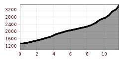
Length:12.0 kmDuration:5:00 hElevation uphill:936 m
High tour starting in the Vals valley via the Altereralm and Gera hut to the shapely summit pyramid of the Olperer, the highest mountain of the Tuxer Alps. The path leads over the Olpererferner to the Wildlahnerscharte and from there along the west ridge to the summit.
From the back of the Valsertal, you first walk through the lonely Altereralm and untouched Swiss stone pine forests to the Gera Hut, beautifully situated below the mighty rock faces of the Fusenstein. From here, after a short ascent over old moraines, you reach the foothills of the Olperer glacier. After donning your mountaineering gear, you continue along the Ferner, past the once mighty ice hump to the Wildlahnerscharte, which represents the transition to the Zillertal. Before you can change to the north ridge, there is a very steep section along the glacier and the often wide crevasse has to be crossed. Finally, the 3476m heighted summit is approached in an easy climbing but very exposed way alongside the ridge. One is rewarded with a fantastic far view, from the Grossglockner area in the east up to the Ortler and Bernina group in the west.
ROUTE DESCRIPTION
From the car park "Unterm Nock" the access road first goes backwards a little, before a narrow path branches off on the right side of the road towards the tourist rest. Once there, the forest road to the Altereralm begins, alternating between alpine meadows and alder woods. After a good hour in an easterly direction, you finally reach the lift hut and with it the end of the forest road, now you continue on a wide, well-maintained path. This leads on the left side of the valley in relatively flat serpentines a good 400 hm in serpentines through a rustic Swiss stone pine forest to the top. Again and again there is the possibility to take short cuts, which shorten the length of the path considerably and speed up the ascent. Finally you reach the timber line and with it a gate, here the Alpeiner Alm begins. The path continues in two arches around the alpine building and then in a continuous south-easterly direction towards the hut, which is clearly visible on a hilltop below the footstone massif. After some time you reach a ditch, which you do not yet cross but climb parallel to it. A little later, one reaches a newly built bridge directly at the hut's height, where the access path from Schmirn also leads. The first stage goal, the Gera hut, is thus reached. If you want to climb further immediately, just stay on the left side of the ditch and follow the path coming from Schmirn for about 100m. Marked by a signpost, the path finally turns off to the Olperer, which first leads through the last alpine pastures, and later along the old glacial moraine. After another good 400 hm one reaches the foothills of the Olpererferner, now it is time to put on the glacier equipment. Once this is done, one follows the left edge of the glacier upwards, close to the lateral rocky ridge. Below the so-called Eisbuckels, a formerly mighty ice wall, one slightly turns to the left and avoids it, a little later one gets acuh to the Wildlahnerscharte. Now the most difficult and dangerous part of the tour is still to be mastered, the short steep ascent over the north-eastern ice field. But after about 100 meters, when the terrain just begins to flatten out a little, this challenge is done and after crossing the (often wide) crevasse, you reach the northern summit ridge by turning left. This ridge is climbed in easy climbing (2+), also some stirrups, which can be used as belay points, are drilled in. Although climbing the ridge is nice and easy, it is very exposed on both sides, so appropriate belaying measures should be taken in any case. After climbing over a last smaller overhang it is finally done and one stands on the summit of the 3476m high peak.
TIP OF THE AUTHOR
To manage the high tour on the Olperer with its almost 2200 hm in one day is a big challenge. It is more pleasant to climb up to the Gera hut the day before, to spend the night there in a great ambience and then to try a summit attempt the next day.


.jpg")
")


 (1).jpg")


.JPG")
