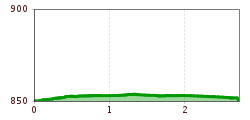
Open interactive mapOpen this POI on the interactive mapElevation profiledownloadHistorischer Spaziergang durch Reutte.gpx
Barrierefreier Themenweg am Schlosskopf © Inn-Frame Fotografie www.inn-frame.at Barrier-free theme trail at the castle headDifficulty:easyLength:1.0 kmDuration:0:20 hElevation uphill:26 mSee trailSee trail: Barrier-free theme trail at the castle head
Pfad zur Dürrenberg Alm © Rene Paulweber Koflerjoch summit hikeDifficulty:difficultLength:9.3 kmDuration:4:45 hElevation uphill:933 mSee trailSee trail: Koflerjoch summit hike
Frauenseestube Luftbild © Robert Eder Winter Hike to Lake Frauensee from LechaschauDifficulty:easyLength:7.2 kmDuration:2:30 hElevation uphill:122 mGo to winter hikeGo to winter hike: Winter Hike to Lake Frauensee from Lechaschau
Winterwandern in der Naturparkregion Reutte © Peter Neusser Hike to the Ehrenberg castle ruinsDifficulty:mediumLength:5.1 kmDuration:1:45 hElevation uphill:237 mGo to winter hikeGo to winter hike: Hike to the Ehrenberg castle ruins
Langlaufloipe © Dominik Somweber, Naturparkregion Reutte Höfener Wiesen circuitOpening hours:closedDifficulty:easyLength:2.2 kmDuration:0:45 hElevation uphill:33 m:Style: Skating, ClassicGo to Cross-country skiing trailGo to Cross-country skiing trail: Höfener Wiesen circuit
Vilser Alm im Winter © Robert Eder Winter walk to the Vilser Alm hutDifficulty:mediumLength:6.6 kmDuration:2:30 hElevation uphill:348 mGo to winter hikeGo to winter hike: Winter walk to the Vilser Alm hut
Lechweg - Gemütliche Variante - Etappe 7 - Weißenbach bis PflachMore InformationMore Information: Lechweg - Gemütliche Variante - Etappe 7 - Weißenbach bis Pflach
Lechweg - Leisurely variant - Stage 8 - Pflach to Füssen in the AllgäuMore InformationMore Information: Lechweg - Leisurely variant - Stage 8 - Pflach to Füssen in the Allgäu
Höfener Alm © TVB Naturparkregion Reutte Hike up the HahnenkammDifficulty:mediumLength:15.4 kmDuration:5:30 hElevation uphill:968 mSee trailSee trail: Hike up the Hahnenkamm
Radfahrerinnen bei herbstlichem Wetter auf dem Weg zur Gaistalalm.jpg © Region Seefeld; Timo Borkowski Bikepacking Tour Tyrol - Stage 2Difficulty:difficultLength:77.0 kmDuration:6:47 hElevation uphill:1,420 mGo to biketourGo to biketour: Bikepacking Tour Tyrol - Stage 2
Vogelbeobachtungsturm - Pflacher Au © Anna Edes Circular walk on the bird trailDifficulty:easyLength:1.7 kmDuration:0:30 hSee trailSee trail: Circular walk on the bird trail
Füssener Hütte © Rene Paulweber Through the Tannheim mountains | 4-day tourDifficulty:mediumLength:35.0 kmDuration:15:00 hElevation uphill:2,200 mSee trailSee trail: Through the Tannheim mountains | 4-day tour
Trailarea Urisee - D'Oachkätzla Line © Dominik Somweber Trailarea UriseeOpening hours:openLength:1.2 kmGo to biketourGo to biketour: Trailarea Urisee
Vilser Alm © Rene Paulweber / Fotostudio Rene Vilser Alm HikeDifficulty:easyLength:6.6 kmDuration:2:45 hElevation uphill:348 mSee trailSee trail: Vilser Alm Hike
Dürrenberg © Gerhard Eisenschink Winter Hike to Dürrenberg AlmDifficulty:difficultLength:6.0 kmDuration:3:00 hElevation uphill:520 mGo to winter hikeGo to winter hike: Winter Hike to Dürrenberg Alm
Lechtal_Tyrol Advertising_Olaf Unverzart_No location specified (3) © Tirol Werbung | Olaf Unverzart Gravelbike Tour 3Opening hours:openDifficulty:difficultLength:83.0 kmDuration:7:00 hElevation uphill:880 mGo to biketourGo to biketour: Gravelbike Tour 3
Alpenrosenweg © TVB Naturparkregion Reutte Wheelchair-Accessible Hahnenkamm Hiking TrailDifficulty:easyLength:5.2 kmDuration:1:30 hElevation uphill:90 mSee trailSee trail: Wheelchair-Accessible Hahnenkamm Hiking Trail
Auf dem Jubiläumsweg, im Hintergrund der Hochvogel. © www.grenzgaenger-wandern.com Grenzgänger Stage 3 - Via the Jubilee Trail to the Prinz-Luitpold HouseDifficulty:mediumLength:12.3 kmDuration:6:00 hElevation uphill:745 mSee trailSee trail: Grenzgänger Stage 3 - Via the Jubilee Trail to the Prinz-Luitpold House
On the Lech Cycle Path ⒸRobert Eder, Reutte Nature Park Region © Naturparkregion Reutte | Robert Eder LechradwegLength:244.6 kmDuration:18:00 hElevation uphill:1,702 mGo to biketourGo to biketour: Lechradweg
Give feedback for a chance to win a special holiday experience!Click here for the surveyClick here for the survey