Sports Airfield Running Circuit

St. Johann in Tirol / Loferer Steinberge
Route length: 8.0 km

The running circuit leads around the sports airfield.

Tour information

  • Length: 8.0 km
  • Elevation uphill:35 hm
  • Elevation downhill:35 hm

Starting point

St. Johann in Tirol - Gasthof Hauser

Finishing point

St. Johann in Tirol - Gasthof Hauser
Source: Kitzbüheler Alpen - St. Johann in Tirol

Description

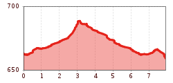
Start the Sportflugplatz running circuit at Gasthof Hauser in Niederhofen. First turn right in the direction of Kirchdorf. Keep right again at the next crossroads. Pass a chapel and continue to the hamlet of Mitterndorf and on to Oberhofen. Here you can already see the sports airfield in the middle of the meadows. Walk to Reitham and after the farms to the Fieberbrunner Ache. Always within sight of the sports airfield and along the river, you will reach the Moar farm. Take the path on the right back to Oberhofen. After the fields, turn left at the Oberhof settlement. After approx. 500 meters, take the Mitterndorferweg back to the hamlet of Mitterndorf. Opposite the chapel, a meadow path leads back to Gasthof Hauser.

Nearby huts and mountain restaurants

More tours in the surrounding area

  • Schnackler Adventure Trail

    Difficulty: easy
    Length: 2.0 km Duration: 0:45 h Elevation uphill: 130 m
  • Alpine Outdoor Gallery

    Difficulty: easy
    Length: 3.4 km Duration: 1:00 h Elevation uphill: 117 m
  • Hinterkaiser-Höflinger Trail

    Opening hours: closed
    Difficulty: difficult
    Length: 13.3 km Elevation uphill: 174 m : Style: Skating, Classic
  • OD Trails

    Opening hours: closed
    Difficulty: medium
  • Wilder-Kaiser-Steig - Detour

    Difficulty: difficult
    Length: 33.0 km Duration: 16:49 h Elevation uphill: 2,311 m
  • Eagle Walk Stage 01: St. Johann in Tirol - Gaudeamushütte

    Difficulty: medium
    Length: 13.0 km Duration: 5:00 h Elevation uphill: 1,060 m
  • Scenic River Trail Großache

    Difficulty: easy
    Length: 14.3 km Duration: 3:30 h Elevation uphill: 20 m
  • Angereralm - Harschbichl

    Difficulty: medium
    Length: 18.2 km Duration: 2:00 h Elevation uphill: 942 m
  • Bichlachrunde

    Difficulty: easy
    Length: 10.5 km Duration: 3:30 h Elevation uphill: 295 m
  • Kalkstein Loop

    Difficulty: medium
    Length: 41.7 km Duration: 3:30 h Elevation uphill: 341 m
  • Angerer Alm

    Difficulty: medium
    Length: 5.7 km Duration: 2:45 h Elevation uphill: 652 m
  • Eichenhof

    Place: St. Johann in Tirol Difficulty: medium
    Length: 4 m Duration: 2:30 h Elevation uphill: 920 m
  • Eifersbacher Wasserfall

    Difficulty: medium
    Length: 5.9 km Duration: 2:30 h Elevation uphill: 241 m
  • Kaiserbachtal - Feldberg - Stripsenjoch

    Difficulty: medium
    Length: 21.0 km Duration: 9:00 h Elevation uphill: 1,170 m
Newsletter

The mountain is calling? So does our newsletter!

In our monthly newsletter we reveal the best holiday tips for Tyrol.