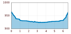
Open interactive mapOpen this POI on the interactive mapElevation profileSpazierweg "Brühl - Hochstein".gpx
Singletrail Kals © Miriam Raneburger Gornerwald Trail No. 139Difficulty:difficultLength:2.3 kmDuration:0:30 hGo to biketourGo to biketour: Gornerwald Trail No. 139
High and sacred – Section 02 from St. Korbinian to Maria LuggauMore InformationMore Information: High and sacred – Section 02 from St. Korbinian to Maria Luggau
High and sacred – Stage 05 from Innichen to KalksteinMore InformationMore Information: High and sacred – Stage 05 from Innichen to Kalkstein
sonnenaufgangstour-boesesweibele-sommer2020-c-attic-film-gmbh © Attic Film GmbH Böses WeibeleDifficulty:easyLength:10.0 kmDuration:4:00 hElevation uphill:545 mSee trailSee trail: Böses Weibele
©-TVB-Tiroler-Oberland-Kaunertal-Daniel-Zangerl-2016-Gepatschhaus-(3).jpg © Daniel Zangerl Rolli-Wanderung GepatschhausLength:8.5 kmDuration:1:45 hElevation uphill:156 mSee trailSee trail: Rolli-Wanderung Gepatschhaus
Wandern am Penken © Christian Lorenz Themed hike: Mayrhofen "PanoramaRundWeg" at Mount PenkenDifficulty:easyLength:4.4 kmDuration:1:45 hElevation uphill:195 mSee trailSee trail: Themed hike: Mayrhofen "PanoramaRundWeg" at Mount Penken
Lakata Trail © bikeboard/Roland Kachelhauser Alban Lakata Trail No. 142Difficulty:mediumLength:2.0 kmDuration:0:20 hElevation uphill:10 mGo to biketourGo to biketour: Alban Lakata Trail No. 142
Langlauf und Biathlon in St. Johann © Mirja Geh Kramerhof Cross-Country trailOpening hours:closedDifficulty:easyLength:1.2 km:Style: Skating, ClassicGo to Cross-country skiing trailGo to Cross-country skiing trail: Kramerhof Cross-Country trail
©-TVB-Tiroler-Oberland-Kaunertal-Daniel-Zangerl-Piller-Moor-Familie-2014-(28).jpg © Daniel Zangerl Rolli-Wanderung Piller MoorDifficulty:easyLength:2.0 kmSee trailSee trail: Rolli-Wanderung Piller Moor
Benni-Raich-Brücke_0518_001.jpg © TVB Pitztal/Chris Walch Arzl - Benni-Raich-Bridge - WaldDifficulty:easyLength:1.8 kmDuration:0:40 hElevation uphill:120 mSee trailSee trail: Arzl - Benni-Raich-Bridge - Wald
©-TVB-Tiroler-Oberland-Kaunertal-Michaela-Gasser-Mark-Handbikebattle-2017-8863.jpg © Michaela Gasser-Mark Handbike Route Kaunertaler GletscherDifficulty:difficultLength:27.5 kmDuration:4:00 hElevation uphill:1,500 mGo to biketourGo to biketour: Handbike Route Kaunertaler Gletscher
Breitegg tourDifficulty:mediumLength:11.0 kmDuration:5:00 hElevation uphill:680 mSee trailSee trail: Breitegg tour
High and sacred – Stage 01 from Lavant to St. KorbinianMore InformationMore Information: High and sacred – Stage 01 from Lavant to St. Korbinian
hochundheilig1-etappe3-obertilliach-c-peter-maier.jpg © Peter Maier High and sacred – Stage 03 from Maria Luggau to St. OswaldDifficulty:mediumLength:25.8 kmDuration:7:00 hElevation uphill:1,206 mSee trailSee trail: High and sacred – Stage 03 from Maria Luggau to St. Oswald
High and sacred – Stage 08 from Obermauern to KalsMore InformationMore Information: High and sacred – Stage 08 from Obermauern to Kals
hochundheilig-stage4-hollbruck-c-peter-maier.jpg © Peter Maier High and sacred – Stage 04 from St. Oswald to InnichenMore InformationMore Information: High and sacred – Stage 04 from St. Oswald to Innichen
High and sacred – Stage 06 from Kalkstein to St. Jakob im DefereggentalMore InformationMore Information: High and sacred – Stage 06 from Kalkstein to St. Jakob im Defereggental
Kaiserlift Tour tip 1: Berghaus Aschenbrenner und Duxer AlmDifficulty:easyLength:4.9 kmElevation uphill:35 mSee trailSee trail: Kaiserlift Tour tip 1: Berghaus Aschenbrenner und Duxer Alm
©-TVB-Tiroler-Oberland-Kaunertal-Daniel-Zangerl-Falkaunsalm-2016-(6).jpg © Daniel Zangerl Rolli-Wanderung FalkaunsalmDifficulty:mediumLength:4.5 kmDuration:1:45 hElevation uphill:392 mSee trailSee trail: Rolli-Wanderung Falkaunsalm
©-TVB-Tiroler-Oberland-Kaunertal-Daniel-Zangerl-2016-Nassereinalm-(5).jpg © Daniel Zangerl Rolli-Wanderung NassereinalmDifficulty:mediumLength:5.5 kmDuration:1:45 hElevation uphill:269 mSee trailSee trail: Rolli-Wanderung Nassereinalm
Adlertrail © bikeboard/Roland Kachelhauser Adlertrail No. 138Difficulty:mediumLength:3.7 kmDuration:0:20 hGo to biketourGo to biketour: Adlertrail No. 138
©-TVB-Tiroler-Oberland-Kaunertal-Die-West-Barrierefrei-Langlaufen-1 (3).jpg © Die West GmbH Adaptive cross country skiing circuit Anger at Kaunertal ValleyOpening hours:closedDifficulty:easyLength:1.0 kmElevation uphill:5 m:Style: Skating, ClassicGo to Cross-country skiing trailGo to Cross-country skiing trail: Adaptive cross country skiing circuit Anger at Kaunertal Valley
Kaiserwinkl_Winterurlaub_Langlaufen (12).JPG © www.bernhardbergmann.com Kaiserwinklloipe start Schwendt - No. 1Opening hours:closedDifficulty:difficultLength:27.0 kmDuration:2:30 hElevation uphill:560 m:Style: Skating, ClassicGo to Cross-country skiing trailGo to Cross-country skiing trail: Kaiserwinklloipe start Schwendt - No. 1
The First OneDifficulty:mediumLength:2.4 kmDuration:0:15 hGo to biketourGo to biketour: The First One
Give feedback for a chance to win a special holiday experience!Click here for the surveyClick here for the survey


.jpg")


.jpg")


.jpg")


")
.jpg")
.jpg")

.jpg")
.JPG")

