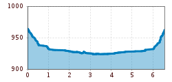
Open interactive mapOpen this POI on the interactive mapElevation profileSpazierweg "Brühl - Hochstein".gpx
am Seeufer entlang von Maurach nach Pertisau © Achensee Tourismus Handbike ride Achenkirch - PertisauDifficulty:mediumLength:13.5 kmDuration:1:00 hElevation uphill:35 mGo to biketourGo to biketour: Handbike ride Achenkirch - Pertisau
der Weg am Ufer des Achensees ist ein tolles Handbiker Areal © Achensee Tourismus Handbike ride Maurach - AchenkirchDifficulty:mediumLength:9.0 kmDuration:1:00 hElevation uphill:35 mGo to biketourGo to biketour: Handbike ride Maurach - Achenkirch
prosseggklamm-matrei-2024-c-peter-maier72_TVB Osttirol_Peter Maier_Matrei in Osttirol.jpg © Peter Maier Circular Hike Proßeggklamm - Hinteregg - Matrei i. O.Difficulty:mediumLength:12.4 kmDuration:5:20 hElevation uphill:722 mSee trailSee trail: Circular Hike Proßeggklamm - Hinteregg - Matrei i. O.
Adlerweg © Lechtal Tourismus Lechtaler Höhenweg: 6th stage: Württemberger Haus-Steinseehütte-Hanauer HütteDifficulty:difficultLength:9.5 kmDuration:5:15 hElevation uphill:713 mSee trailSee trail: Lechtaler Höhenweg: 6th stage: Württemberger Haus-Steinseehütte-Hanauer Hütte
Leutkircher-Hütte © Lechtal Tourismus Lechtaler Höhenweg 1st stage: Stuttgarter Hütte-Leutkircher HütteDifficulty:difficultLength:7.7 kmDuration:3:15 hElevation uphill:429 mSee trailSee trail: Lechtaler Höhenweg 1st stage: Stuttgarter Hütte-Leutkircher Hütte
Trailarea Urisee - D'Oachkätzla Line © Dominik Somweber Trailarea UriseeOpening hours:openLength:1.2 kmGo to biketourGo to biketour: Trailarea Urisee
Wildtierweg Fuchs.jpg © © Serfaus-Fiss-Ladis Marketing GmbH Wild Animals TrailOpening hours:openDifficulty:easySee trailSee trail: Wild Animals Trail
Leutkircher-Hütte © Lechtal Tourismus Lechtaler Höhenweg 1st stage: Stuttgarter Hütte-Leutkircher HütteDifficulty:difficultLength:6.6 kmDuration:3:15 hElevation uphill:469 mSee trailSee trail: Lechtaler Höhenweg 1st stage: Stuttgarter Hütte-Leutkircher Hütte
Lechweg - Leisurely variant - Stage 3 - Warth to SteegMore InformationMore Information: Lechweg - Leisurely variant - Stage 3 - Warth to Steeg
Lechweg - Etappe 1 - Formarinsee bis Lech am ArlbergMore InformationMore Information: Lechweg - Etappe 1 - Formarinsee bis Lech am Arlberg
Lechweg - Leisurely variant - Stage 6 - Elmen to WeißenbachMore InformationMore Information: Lechweg - Leisurely variant - Stage 6 - Elmen to Weißenbach
Lechweg - Leisurely variant - Stage 5 - Bach to ElmenMore InformationMore Information: Lechweg - Leisurely variant - Stage 5 - Bach to Elmen
Lechweg - Leisurely variant - Stage 8 - Pflach to Füssen in the AllgäuMore InformationMore Information: Lechweg - Leisurely variant - Stage 8 - Pflach to Füssen in the Allgäu
©-TVB-Tiroler-Oberland-Kaunertal-Michael-Veit-Klima-Führer-2018-Talwanderweg-Vergötschen-Platz-2018 © Michael Veit Talwanderweg KaunertalDifficulty:easyDuration:2:30 hElevation uphill:295 mSee trailSee trail: Talwanderweg Kaunertal
Gallruth Stollenwanderung_Daniel Zangerl.jpg © Daniel Zangerl Kaunerberger WasserwegDifficulty:mediumLength:15.2 kmDuration:6:00 hElevation uphill:935 mSee trailSee trail: Kaunerberger Wasserweg
Tux - Höllensteinhütte-Grieralm-RundeDifficulty:mediumLength:12.5 kmDuration:2:30 hElevation uphill:565 mGo to biketourGo to biketour: Tux - Höllensteinhütte-Grieralm-Runde
Söll_Tour de Tirol_Wilder Kaiser © TVB Wilder Kaiser/eafoto.at Pölven trail training circular routeLength:22.8 kmElevation uphill:1,110 mGo to trailGo to trail: Pölven trail training circular route
Namlos suspension bridge © Außerhofer Hanspeter Namlos - FallerscheinDifficulty:easyLength:3.8 kmElevation uphill:37 mSee trailSee trail: Namlos - Fallerschein
Kundl GorgeOpening hours:openDifficulty:easyLength:6.5 kmDuration:3:00 hElevation uphill:10 mSee trailSee trail: Kundl Gorge
Wildschönau Niederau Auenweg Sommer © Wildschönau Tourismus Auenweg NiederauDifficulty:easyLength:1.0 kmDuration:0:30 hElevation uphill:31 mGo to winter hikeGo to winter hike: Auenweg Niederau
Blick nach Vorderhornbach © Lechtal Tourismus Stanzach - Baichlstein - high trail to VorderhornbachDifficulty:mediumLength:10.0 kmDuration:3:10 hElevation uphill:288 mSee trailSee trail: Stanzach - Baichlstein - high trail to Vorderhornbach
Kaiserjochhaus © Lechtal Tourismus Lechtaler Höhenweg: 3. Etappe Kasierjochhaus-Ansbacher HütteDifficulty:difficultLength:6.9 kmDuration:4:45 hElevation uphill:745 mSee trailSee trail: Lechtaler Höhenweg: 3. Etappe Kasierjochhaus-Ansbacher Hütte
Kaiserjochhaus © Lechtal Tourismus Lechtaler Höhenweg: 3. Etappe Kasierjochhaus-Ansbacher HütteDifficulty:difficultLength:7.8 kmDuration:4:45 hElevation uphill:855 mSee trailSee trail: Lechtaler Höhenweg: 3. Etappe Kasierjochhaus-Ansbacher Hütte
Lech bei Forchach. © Lechtal Tourismus Stanzach - Over the suspension bridgeDifficulty:easyLength:12.8 kmDuration:3:15 hElevation uphill:38 mSee trailSee trail: Stanzach - Over the suspension bridge
Kaiserjochhaus © Lechtal Tourismus Lechtaler Höhenweg: 3. Etappe Kasierjochhaus-Ansbacher HütteDifficulty:difficultLength:7.9 kmDuration:4:15 hElevation uphill:518 mSee trailSee trail: Lechtaler Höhenweg: 3. Etappe Kasierjochhaus-Ansbacher Hütte
Give feedback for a chance to win a special holiday experience!Click here for the surveyClick here for the survey


-min.jpg")


.jpg")


