
Opening hours:Open today
Place:Längenfeld
:Alpine pasture / hut / mountain restaurant
HUBEN -> Breitlehnalm -> Breitlehnjoch -> Kapuzinerjoch -> Gahwinden -> Rüsselsheimer Hut -> PARKING LOT WEISSWALD
Suitable for those free from dizziness, sure-footed, and alpine experienced climbers;
Very good physical condition, alpine experience and mountain equipment (see under equipment), sometimes
alpine safety gear, good weather conditions recommended
Please check the current weather report at: www.oetztal.com/de/sommer.html
Appropriate equipment such as breathable and weather-appropriate outdoor clothing,
ankle-high hiking boots, wind, rain, and sun protection, a hat, possibly gloves, is required for all
hikes and routes. Carrying a first aid kit, a mobile phone, and possibly
a map, as well as sufficient provisions on hikes without the possibility of stopping for food, is necessary.
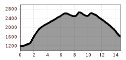
Those who choose to ascend on foot start from the small group of houses "Mühl" in Huben via a trail directly to Breitlehnalm.From the alm, a trail leads into the entrance of the pasture-rich high valley and ascends steadily upwards until reaching the valley floor filled with scree and rocks. From Breitlehnjoch, one can see for the first time the characteristic Kaunergrat (Watzespitze, Verweilspitze ...). A complete view that constantly amazes you. The trail to Kapuzinerjöchl requires full attention. After crossing a scree slope, small switchbacks lead very steeply through rocky terrain up to the col. Through the Rötenkar, first descending, and then rising on the opposite slope, you reach the viewpoint Gahwinden. The Rüsselsheimer hut (about 45 minutes away) is already visible. During the descent into the Pitztal to the parking lot between Weißwald and Plangeross, you are accompanied by the view of the distinctive rock formations of the Kaunergrat mountains.
Travel comfortably and safely by train. The terminal or exit point is ÖTZTAL station. Afterwards, you can travel conveniently and quickly by public transport or local taxi companies through the entire valley to your destination. The current bus schedule is available at: fahrplan.vvt.at
The following parking lots are available:Huben - Funpark - free of charge


