Description
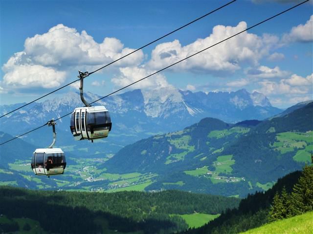
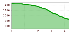
Take the gondola to the Norderberg Alm. From there continue on the forest path back down to the valley and come out in the Wildenbach part of Niederau.
Museum goes wild - digital circular walkDifficulty: easy Length: 700 m Duration: 0:30 h See trailSee trail: Museum goes wild - digital circular walk
Mountain station Spieljochbahn - Hochfügen Difficulty: medium Length: 12.2 km Duration: 4:00 h Elevation uphill: 270 m See trailSee trail: Mountain station Spieljochbahn - Hochfügen
Hamberg (2095m) from the Gasthof Almluft (Trail No. 37)Difficulty: medium Length: 9.4 km Duration: 4:45 h Elevation uphill: 865 m See trailSee trail: Hamberg (2095m) from the Gasthof Almluft (Trail No. 37)
Mountain Hike to the WedelhütteDifficulty: medium Length: 3.0 km Duration: 3:00 h Elevation uphill: 490 m See trailSee trail: Mountain Hike to the Wedelhütte
Berwang circular hike AlmkopfDifficulty: easy Length: 8.9 km Duration: 3:30 h Elevation uphill: 466 m See trailSee trail: Berwang circular hike Almkopf
Summit hike Salfainssee - Schaflegerkogel (2,405 m) - Kemater Alm mountain hutDifficulty: medium Length: 14.8 km Duration: 7:00 h Elevation uphill: 1,029 m See trailSee trail: Summit hike Salfainssee - Schaflegerkogel (2,405 m) - Kemater Alm mountain hut
BiathlonpfadDifficulty: medium Length: 14.0 km Duration: 4:00 h Elevation uphill: 360 m See trailSee trail: Biathlonpfad
Peter Habeler RundeDifficulty: difficult Length: 41.3 km Duration: 17:00 h Elevation uphill: 2,236 m See trailSee trail: Peter Habeler Runde
Foodie TrailDifficulty: easy Length: 3.0 km Duration: 1:39 h Elevation uphill: 210 m See trailSee trail: Foodie Trail
Oberau - KragenjochkreuzDifficulty: medium Length: 7.9 km Duration: 3:00 h Elevation uphill: 513 m See trailSee trail: Oberau - Kragenjochkreuz
Hintere Goinger Halt summit tourDifficulty: difficult Length: 8.9 km Duration: 6:30 h Elevation uphill: 1,090 m See trailSee trail: Hintere Goinger Halt summit tour
Panoramic circuit Brandstadl–HartkaiserDifficulty: easy Length: 6.0 km Duration: 1:50 h Elevation uphill: 170 m See trailSee trail: Panoramic circuit Brandstadl–Hartkaiser
SchafsiedelDifficulty: medium Length: 15.6 km Duration: 6:45 h Elevation uphill: 1,280 m See trailSee trail: Schafsiedel
Schleier Waterfall circular hiking routeDifficulty: medium Length: 5.5 km Duration: 3:30 h Elevation uphill: 520 m See trailSee trail: Schleier Waterfall circular hiking route
Kundl GorgeOpening hours: closed Difficulty: easy Length: 6.5 km Duration: 3:00 h Elevation uphill: 10 m See trailSee trail: Kundl Gorge
Hollenauer Kreuz circular hiking routeDifficulty: easy Length: 5.8 km Duration: 2:15 h Elevation uphill: 290 m See trailSee trail: Hollenauer Kreuz circular hiking route
The Wildschönau High TrailDifficulty: medium Length: 14.8 km Duration: 6:30 h Elevation uphill: 760 m See trailSee trail: The Wildschönau High Trail
TaubenseeDifficulty: medium Length: 13.0 km Duration: 5:00 h Elevation uphill: 620 m See trailSee trail: Taubensee
Hochalm hikeDifficulty: medium Length: 19.6 km Duration: 7:00 h Elevation uphill: 1,140 m See trailSee trail: Hochalm hike
Voldöpper Spitze Loop HikeDifficulty: medium Length: 12.9 km Duration: 5:00 h Elevation uphill: 988 m See trailSee trail: Voldöpper Spitze Loop Hike
Kundler KlammOpening hours: closed Difficulty: easy Length: 6.4 km Duration: 2:00 h Elevation uphill: 116 m See trailSee trail: Kundler Klamm
Farmkehralm 1.521 mDifficulty: medium Length: 9.3 km Duration: 3:30 h Elevation uphill: 506 m See trailSee trail: Farmkehralm 1.521 m
Wiedersberger Horn Panorama PathDifficulty: easy Length: 4.1 km Duration: 1:30 h Elevation uphill: 195 m See trailSee trail: Wiedersberger Horn Panorama Path
Discovering the Tiefenbach Gorge HikeDifficulty: medium Length: 5.7 km Duration: 3:30 h Elevation uphill: 669 m See trailSee trail: Discovering the Tiefenbach Gorge Hike
Lake Zirein via SonnwendjochberghausDifficulty: medium Length: 18.4 km Duration: 6:15 h Elevation uphill: 894 m See trailSee trail: Lake Zirein via Sonnwendjochberghaus
Give feedback for a chance to win a special holiday experience!Click here for the surveyClick here for the survey