Graf Ferdinand HausPlace:Kühtai:Tavern, Alpine pasture / hut / mountain restaurant:vegetariansee restaurant detailssee restaurant details: Graf Ferdinand Haus
Drei Seen HüttePlace:Kühtai:Tavern, Alpine pasture / hut / mountain restaurant:vegetariansee restaurant detailssee restaurant details: Drei Seen Hütte
valentinkapelle-1.jpg © Archiv TVB Mayrhofen Mountain hike: Zillergrund - Valentins KapelleDifficulty:mediumLength:3.2 kmDuration:2:30 hElevation uphill:390 mSee trailSee trail: Mountain hike: Zillergrund - Valentins Kapelle
Round hike to Padauner KogelDifficulty:mediumLength:12.0 kmDuration:5:00 hElevation uphill:936 mSee trailSee trail: Round hike to Padauner Kogel
Geraerhütte_JohannesBitter_TVB-Wipptal_170623_105.jpg © JOHANNES BITTER Hike to the Geraer Hütte | Austrian TyrolDifficulty:mediumLength:7.0 kmDuration:5:30 hElevation uphill:1,000 mSee trailSee trail: Hike to the Geraer Hütte | Austrian Tyrol
Lämmerbichl_Tirol Werbung_Sürth Paul_Tux-Hintertux.jpg © Sürth Paul Spring with late crocus blossom in Tux ValleyDifficulty:mediumLength:10.0 kmDuration:4:00 hElevation uphill:640 mSee trailSee trail: Spring with late crocus blossom in Tux Valley
Barrierefreier Themenweg am Schlosskopf © Inn-Frame Fotografie www.inn-frame.at Barrier-free theme trail at the castle headDifficulty:easyLength:1.0 kmDuration:0:20 hElevation uphill:26 mSee trailSee trail: Barrier-free theme trail at the castle head
miamariaknoll_srk2022_silberpfad-9735 © TVB Silberregion Karwendel | Mia Maria Knoll Tiroler SilberpfadDifficulty:easyLength:88.0 kmDuration:32:00 hElevation uphill:3,500 mSee trailSee trail: Tiroler Silberpfad
iseltrail-etappe2-feldner-katarakte-c-ramona-walder.jpg © TVB Osttirol/Waldner Ramona IseltrailDifficulty:mediumLength:75.3 kmDuration:24:30 hElevation uphill:2,348 mSee trailSee trail: Iseltrail
Arzkasten winter hikeDifficulty:easyLength:3.8 kmDuration:1:15 hElevation uphill:77 mGo to winter hikeGo to winter hike: Arzkasten winter hike
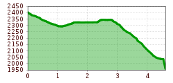
Summit hike Salfainssee - Schaflegerkogel (2,405 m) - Kemater Alm mountain hutDifficulty:mediumLength:14.8 kmDuration:7:00 hElevation uphill:1,029 mSee trailSee trail: Summit hike Salfainssee - Schaflegerkogel (2,405 m) - Kemater Alm mountain hut
Mit dem Nationalpark Ranger unterwegs © NPHT/Martin Lugger Hiking tour to Lucknerhütte 2.241mDifficulty:mediumLength:5.2 kmDuration:2:20 hElevation uphill:320 mSee trailSee trail: Hiking tour to Lucknerhütte 2.241m
BiathlonpfadDifficulty:mediumLength:14.0 kmDuration:4:00 hElevation uphill:360 mSee trailSee trail: Biathlonpfad
Peter Habeler RundeDifficulty:difficultLength:41.3 kmDuration:17:00 hElevation uphill:2,236 mSee trailSee trail: Peter Habeler Runde
Maria-Waldrast_Sommer_JohannesBitter_TVB-Wipptal_120823_067-Bearbeitet.jpg © JOHANNES BITTER Serles (2.717m)Difficulty:difficultLength:8.0 kmDuration:4:30 hElevation uphill:1,080 mSee trailSee trail: Serles (2.717m)
Hochalm Sommer Außenansicht © Hochalm Berwang circular hike AlmkopfDifficulty:easyLength:8.9 kmDuration:3:30 hElevation uphill:466 mSee trailSee trail: Berwang circular hike Almkopf
Badener Huette © Fabian Pimminger Badener HütteDifficulty:difficultLength:23.2 kmDuration:12:00 hElevation uphill:1,754 mSee trailSee trail: Badener Hütte
Family hike-Golzentipp-Kindermeile-TVB-Osttirol-c-Attic-FilmGmbH-Obertilliach.jpg © Attic Film GmbH Children's mile GolzentippOpening hours:openDifficulty:easyLength:3.7 kmDuration:2:00 hElevation uphill:140 mSee trailSee trail: Children's mile Golzentipp
Glocknerkrone_Etappe_1_SudetendeutscheHütte_2023_cPeterMaier-1251.jpg © Peter Maier Hiking tour to Sudetendeutschen Hütte 2.650mDifficulty:mediumLength:15.5 kmDuration:8:15 hElevation uphill:1,203 mSee trailSee trail: Hiking tour to Sudetendeutschen Hütte 2.650m
Stöttlalmbrücke circular hikeDifficulty:easyLength:8.7 kmDuration:2:30 hElevation uphill:117 mSee trailSee trail: Stöttlalmbrücke circular hike
Museum goes wild - digital circular walkDifficulty:easyLength:700 mDuration:0:30 hSee trailSee trail: Museum goes wild - digital circular walk
Kirchdachspitze (2.840m) from TrinsDifficulty:difficultLength:16.0 kmDuration:8:00 hElevation uphill:1,609 mSee trailSee trail: Kirchdachspitze (2.840m) from Trins
Bike&Hike-Gschnitz_JohannesBitter_TVB-Wipptal_300624_018.jpg © Johannes Bitter BlaserDifficulty:mediumLength:11.0 kmDuration:4:30 hElevation uphill:1,067 mSee trailSee trail: Blaser
Ridge hike to the LichtseeDifficulty:mediumLength:13.0 kmDuration:3:30 hElevation uphill:834 mSee trailSee trail: Ridge hike to the Lichtsee
Navis, Stöcklalm_Tirol Werbung_Bitter Johannes_Navis (2) © Tirol Werbung | Johannes Bitter StöcklalmDifficulty:mediumLength:14.0 kmDuration:3:40 hElevation uphill:828 mSee trailSee trail: Stöcklalm
Wildlahner round tour via Ramsgrubnersee, Schoberspitzen (2,602m) and Steinernes Lamm (2,528m)Difficulty:mediumLength:13.0 kmDuration:8:00 hElevation uphill:1,380 mSee trailSee trail: Wildlahner round tour via Ramsgrubnersee, Schoberspitzen (2,602m) and Steinernes Lamm (2,528m)
Jausenstation-St-Magdalena_JohannesBitter_TVB-Wipptal_130823_079.jpg © JOHANNES BITTER To the pilgrimage church of St. Magdalena (1,661 m)Difficulty:mediumLength:3.0 kmDuration:2:30 hElevation uphill:450 mSee trailSee trail: To the pilgrimage church of St. Magdalena (1,661 m)
Give feedback for a chance to win a special holiday experience!Click here for the surveyClick here for the survey


 neu.jpg")


.jpg")
")


