

Place:Hopfgarten im Brixental
:Restaurant
Extensive circular hike from the district of Penning to the Markbachjoch, via the Horlerstiegl and the Maierhofer Joch to the Feldalphorn at almost 2,000 metres above sea level.


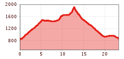
The starting point of this demanding tour is the sports field at Penningberg in Hopfgarten. From there, you start towards Penningdörfl (No. 73).
From Penningdörfl, follow the signs No. 73, past the Mittermoosen See, to the summit of the Markbachjoch (1500 m).
Continue hiking on trail No. 74, past the Holzalm to the chapel at Horler Stiegl. From there, follow the hiking trail further until you reach the Feldalphorn (1923 m) after about one and a half hours.
The descent leads via a mountain path to the Trockenbachalm (No. 74). From there, hike past the Haag Alm further towards Innerpenningberg. Via the Penninger Straße, follow the signs back to the starting point.
Bus stop: Hopfgarten im Brixental Berglift
Train station: Hopfgarten im Brixental Berglift
Regional Guest Card = Train ticket from Kirchbichl to Hochfilzen + Bus ticket from Mariastein to Kitzbühel included
Valid on ÖBB local trains (S, REX) and InterRegio trains (IR) between Kirchbichl - Wörgl and Hochfilzen
Not valid on RJ, RJX, EC, IC, ICE, D and NJ/EN trains
More detailed information at: www.hohe-salve.com/mobilität
The starting point in Penning is not accessible by public transport. This extends the tour by 1 hour.
Coming from Innsbruck/Munich: A12 exit Wörgl Ost – feeder road B178 towards St. Johann i. T. & Kitzbühel – after the tunnel take the exit towards Hopfgarten – at the roundabout take the exit onto the B170 towards Hopfgarten – turn right under the underpass across the bridge towards Kelchsau – head into the valley on L205 Kelchsauer Straße for approx. 200 m – turn right onto Penningbergstraße - after approx. 2 km the destination is on the right-hand side.
Coming from Kitzbühel: B170 Brixentalstraße towards Wörgl – in Hopfgarten before the second railway underpass turn left across the bridge towards Kelchsau – head into the valley on L205 Kelchsauer Straße for approx. 200 m – turn right onto Penningbergstraße - after approx. 2 km the destination is on the right-hand side.
Sportplatz Penningberg


