Mountain hikes Fischteichrunde

Difficulty ratings: easy
Route length: 3.9 km
Duration: 1:00 h

Fischteichrunde

Tour information

  • Requirement: easy
  • Length: 3.9 km
  • Duration: 1:00 h
  • Elevation uphill:34 hm
  • Elevation downhill:34 hm
Highest point617 m

Starting point

Infobüro Hopfgarten

Finishing point

Infobüro Hopfgarten
  • Fitness level 1 / 6
  • Technique 1 / 6

Features

  • Circular route
  • Suitable for families
  • suitable for pushchairs

Best time of year

  • January
  • February
  • March
  • April
  • May
  • June
  • July
  • August
  • September
  • October
  • November
  • December

Trail condition

Asphalt

Equipment

Outdoor clothing, sturdy shoes 
Source: Kitzbüheler Alpen Management GmbH

Description

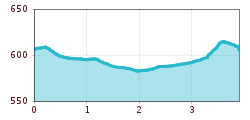
The starting point of the hike is the information office in Hopfgarten. From there you follow the tracks of the long-distance hiking trail KAT Walk into the center of Hopfgarten. Past the Gasthof Traube, the road leads to the Cafe Lois. Directly in front of the cafe, opposite the Raiffaisenbank, turn left into the Lukasfeld and follow the signs No. 72 to the fish pond.
From there, continue walking in the direction of Itter or Gries (No. 72), until you reach the Rahmstätt bridge. After crossing the bridge, keep to the right and walk under the railroad underpass to Hopfgarten.
Return to the starting point via the market center.

Nearby huts and mountain restaurants

Getting here

  • Arrival by public transport

    bus: "Hopfgarten Berglift Bahnhof" (train station)
    train: "Hopfgarten Berglift Bahnhof".

    Guest card of the region = train ticket from Wörgl to Hochfilzen + bus ticket from Mariastein to Kitzbühel included

    More detailed information: www.hohe-salve.com/mobility


  • Parking

    Parking lot P3 Wasserfeld (free of charge)
    Lift parking lot - free of charge when using the gondola

More tours in the surrounding area

  • Ötztal Trek Stage 2

    Difficulty:difficult
    Length:10.7 kmDuration:4:00 hElevation uphill:926 m
  • Ötztal Trek Stage 9

    Difficulty:difficult
    Length:12.8 kmDuration:6:00 hElevation uphill:1,623 m
  • Ötztal Trek Stage 10

    Difficulty:difficult
    Length:11.1 kmDuration:4:30 hElevation uphill:1,476 m
  • Ötztal Trek Stage 7

    Difficulty:difficult
    Length:5.3 kmDuration:2:00 hElevation uphill:376 m
  • Ötztal Trek

    Length:246.4 kmDuration:84:25 hElevation uphill:18,910 m
  • Ötztal Trek Stage 16

    Difficulty:difficult
    Length:6.9 kmDuration:2:30 hElevation uphill:358 m
  • Ötztal Trek Stage 19

    Difficulty:difficult
    Length:11.0 kmDuration:5:00 hElevation uphill:1,246 m
  • Ötztal Trek Stage 6

    Difficulty:difficult
    Length:7.6 kmDuration:3:30 hElevation uphill:640 m
  • Ötztal Trek Stage 3

    Difficulty:difficult
    Length:10.4 kmDuration:4:00 hElevation uphill:842 m
  • 3-day hut tour Wilder Kaiser

    Difficulty:difficult
    Length:24.6 kmDuration:14:00 hElevation uphill:2,060 m
  • Ötztal Trek Stage 1

    Difficulty:medium
    Length:18.6 kmDuration:6:30 hElevation uphill:1,561 m
  • Ötztal Trek Stage 17

    Difficulty:difficult
    Length:16.4 kmDuration:6:00 hElevation uphill:1,080 m
  • Ötztal Trek Stage 14

    Difficulty:difficult
    Length:6.3 kmDuration:3:00 hElevation uphill:1,004 m
  • Sunnenseit'n Weg: Round tour

    Difficulty:medium
    Length:8.2 kmDuration:3:00 hElevation uphill:400 m
  • Ötztal Trek Stage 4

    Difficulty:difficult
    Length:8.9 kmDuration:4:00 hElevation uphill:802 m
  • Ötztal Trek Stage 8

    Difficulty:difficult
    Length:9.3 kmDuration:3:30 hElevation uphill:274 m
  • Ötztal Trek Stage 15

    Difficulty:difficult
    Length:6.5 kmDuration:2:30 hElevation uphill:332 m
  • Ötztal Trek Stage 20

    Opening hours:closed
    Difficulty:medium
    Length:6.4 kmDuration:3:00 hElevation uphill:610 m
  • Ötztal Trek Stage 18

    Difficulty:difficult
    Length:9.5 kmDuration:9:30 hElevation uphill:979 m
Newsletter

The mountain is calling? So does our newsletter!

In our monthly newsletter we reveal the best holiday tips for Tyrol.