Mountain hikes Obstansersee Hütte – Pfannspitze

Kartitsch / Karnischer Hauptkamm
Difficulty ratings: medium
Route length: 14.4 km
Duration: 6:30 h

A dip in the Obstansersee is only for the very hardy - the water temperature barely rises above 10°C and the lake is covered in ice for around 8 months of the year.

Tour character

Challenging mountain tour through the Winklertal valley to the Obstansersee hut (2,304 m) and on to the 2,678 m high Pfannspitze. The trail leads through a picturesque high valley, past the Obstanser See lake, and ends with a steep climb to the summit. A spectacular panoramic view of the Carnic Alps opens up from the top. Ideal for experienced hikers looking for a mixture of nature enjoyment and sporting challenge.

Tour information

  • Requirement: medium
  • Length: 14.4 km
  • Duration: 6:30 h
  • Elevation uphill:1,250 hm
  • Elevation downhill:1,250 hm
Highest point2,678 m

Starting point

Sport- und Freizeitzentrum

Finishing point

Pfannspitze
  • Fitness level 4 / 6
  • Technique 3 / 6

Best time of year

  • January
  • February
  • March
  • April
  • May
  • June
  • July
  • August
  • September
  • October
  • November
  • December
Source: TVB Osttirol

Description

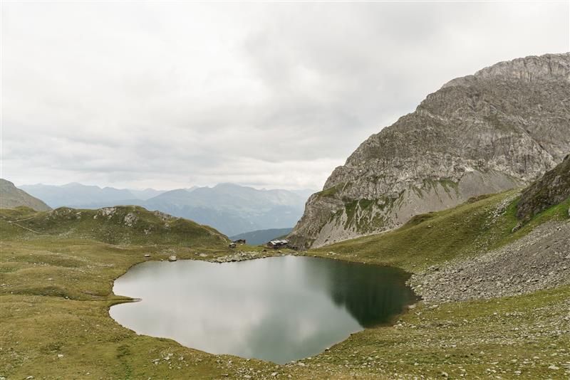
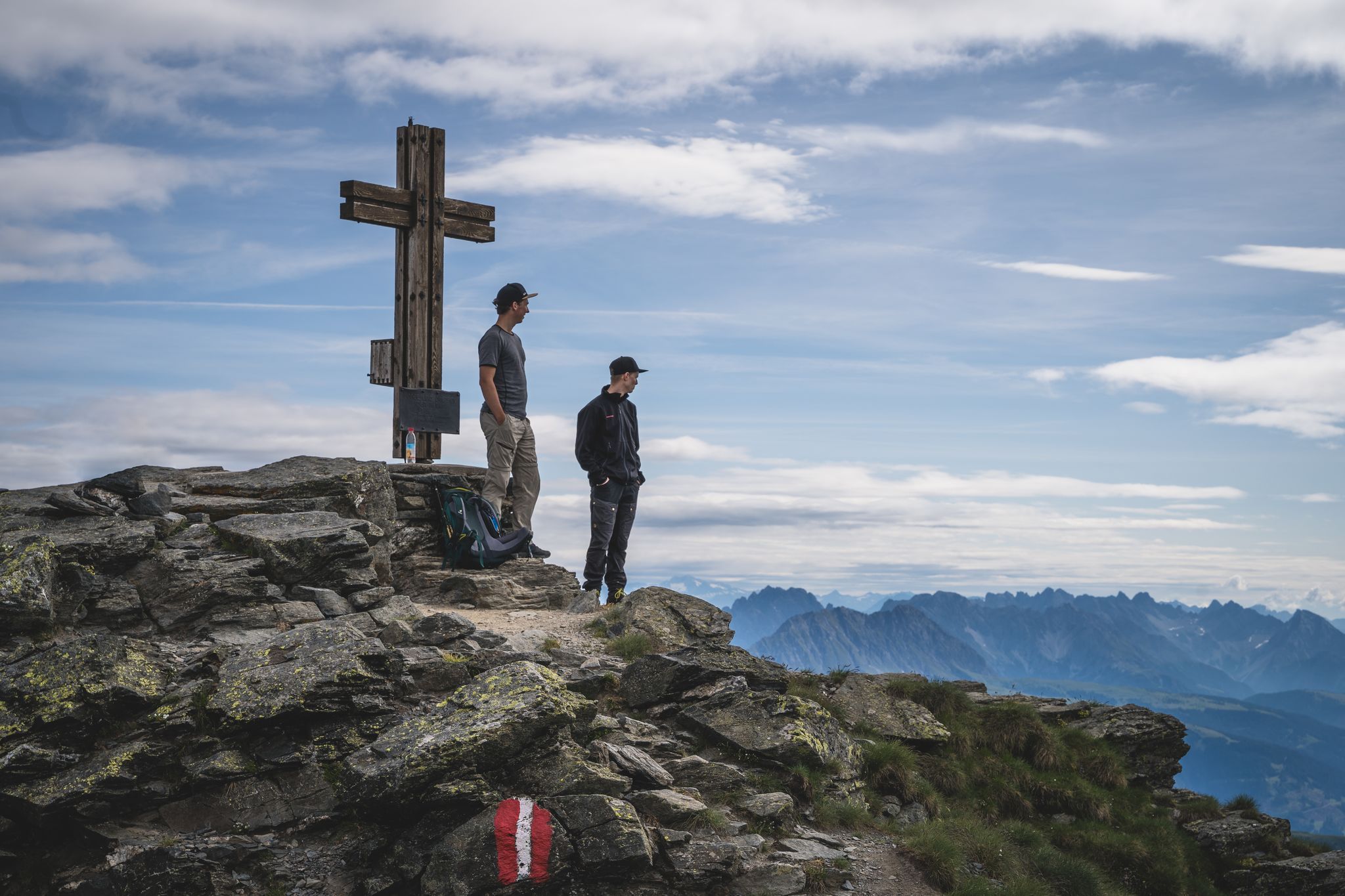
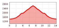
The sports and leisure centre is the starting point. Hike in a southerly direction from there via route 466 to Winklertal and to the steep walled head of the valley. Hairpin bends proceed up to Obstanser See and to Obstansersee Hütte. After a rest at Obstansersee Hütte bear right, heading past the lake, on a steep climb up to the Pfannspitze.

Nearby huts and mountain restaurants

Getting here

  • Arrival by public transport

    Mit dem Bus bis zur Haltestelle "Kartitsch Gemeindeamt"

  • Parking

    Parkplatz Sportzentrum Kartitsch

More tours in the surrounding area

  • Children's mile Golzentipp

    Opening hours: open
    Difficulty: easy
    Length: 3.7 km Duration: 2:00 h Elevation uphill: 140 m
  • Herz-Ass Villgratental

    Difficulty: medium
    Length: 76.0 km Duration: 34:00 h Elevation uphill: 5,750 m
  • The Höfe Trail

    Difficulty: easy
    Length: 50.6 km Duration: 10:15 h Elevation uphill: 1,882 m
  • Lake Schwarzsee

    Difficulty: medium
    Length: 7.8 km Duration: 3:30 h Elevation uphill: 790 m
  • Rote Spitze 2,956 m

    Difficulty: medium
    Length: 10.2 km Duration: 5:30 h Elevation uphill: 1,260 m
  • Golzentipp 2.317 m

    Difficulty: easy
    Length: 5.6 km Duration: 2:00 h Elevation uphill: 267 m
  • Toblacher Pfannhorn

    Difficulty: medium
    Length: 9.8 km Duration: 4:30 h Elevation uphill: 1,020 m
  • Große Kinigat

    Difficulty: difficult
    Length: 8.5 km Elevation uphill: 1,250 m
  • Ganalm-Walderalm

    Difficulty: difficult
    Length: 15.4 km Duration: 4:00 h Elevation uphill: 662 m
  • Höfe Trail stage 1: Sillian - Kartitsch

    Opening hours: closed
    Difficulty: easy
    Length: 11.7 km Duration: 3:00 h Elevation uphill: 551 m
  • Dorfberg

    Difficulty: medium
    Length: 17.6 km Duration: 5:30 h Elevation uphill: 770 m
  • Volkzeiner Hütte

    Difficulty: easy
    Length: 13.4 km Duration: 3:30 h Elevation uphill: 370 m
  • Oberstalleralm

    Difficulty: easy
    Length: 2.8 km Duration: 0:50 h Elevation uphill: 170 m
  • Carnic altitude trail

    Difficulty: medium
    Length: 150.0 km Duration: 26:50 h Elevation uphill: 9,100 m
Newsletter

The mountain is calling? So does our newsletter!

In our monthly newsletter we reveal the best holiday tips for Tyrol.