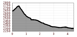
Mountain hikes Valluga - Stuttgarter Hütte 2.310m

Difficulty ratings: difficult
Route length: 4.5 km
Duration: 3:00 h

Valluga - Stuttgarter Hütte 2.310m

Tour information

  • Requirement: difficult
  • Length: 4.5 km
  • Duration: 3:00 h
  • Elevation uphill:160 hm
  • Elevation downhill:0 hm
Highest point2,755 m

Starting point

Valluga 1 Bergstation

Finishing point

Stuttgarter Hütte

Best time of year

  • January
  • February
  • March
  • April
  • May
  • June
  • July
  • August
  • September
  • October
  • November
  • December

Equipment

Good walking boots, poles and drinks/snacks, rain jacket, sun protection
Source: TVB St Anton am Arlberg

Description

From the Vallugabahn 1 mountain station, follow the signs to the northwest. Continue west downhill towards Pazüeltal. On the slopes below the Pazüel and Roggspitze to the Stuttgarter Hütte. From here descend via the A. Endress trail to Zürs (approx. 2 hrs). From there by bus to St. Anton.

Nearby huts and mountain restaurants

More tours in the surrounding area

Newsletter

The mountain is calling? So does our newsletter!

In our monthly newsletter we reveal the best holiday tips for Tyrol.