Mountain hikes Wanderweg Zwölferkopf

Difficulty ratings: easy
Route length: 5.2 km

Gentle descent from the Zwölferkopf (1,500 metres) down to Pertisau: 520 metres downhill on a forest road – with stunning views of the lake and Pertisau.

Tour information

  • Requirement: easy
  • Length: 5.2 km
  • Elevation uphill:0 hm
  • Elevation downhill:520 hm
Highest point1,500 m

Starting point

Pertisau, top station of the Karwendel cable car

Finishing point

Pertisau, valley station of the Karwendel cable car
  • Fitness level 2 / 6
  • Technique 1 / 6

Features

  • Suitable for families

Best time of year

  • January
  • February
  • March
  • April
  • May
  • June
  • July
  • August
  • September
  • October
  • November
  • December

Trail condition

hiking trail

Equipment

Sturdy boots (ankle-high hiking boots), weather appropriate clothing. Telescopic hiking poles are recommended.
Source: Achensee Tourismus

Description

The hiking trail Zwölferkopf starts from the top station of the Karwendel cable car. Walk in the direction of the mountain hut Bärenbadalm. After ca. 200 metres, the forest road branches off to the left and descends through the forest to the valley station of the Karwendel cable car.

Nearby huts and mountain restaurants

  • Alpengasthaus Karwendel

    Opening hours:Today closed
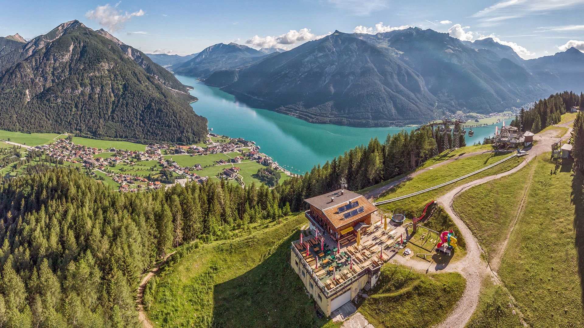
    Place:Pertisau am Achensee
    :Alpine pasture / hut / mountain restaurant
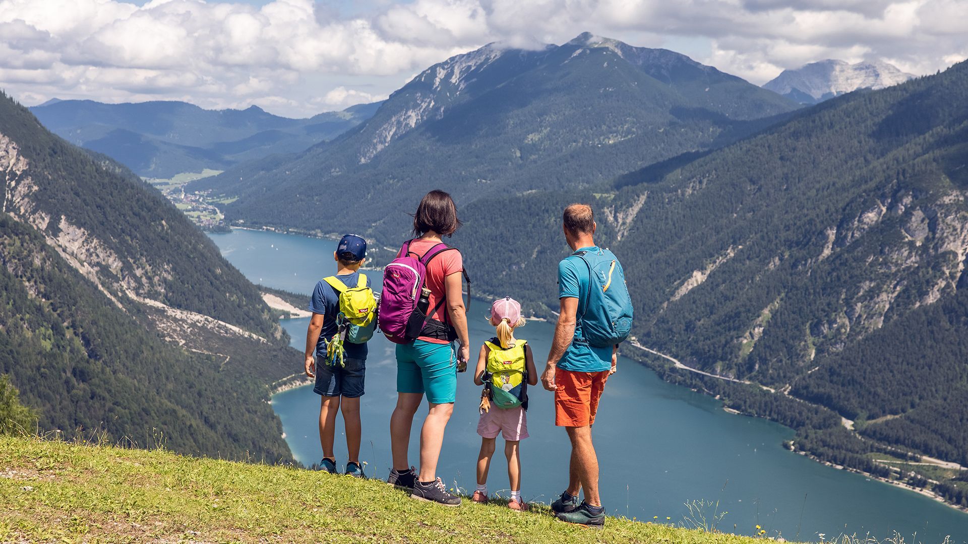
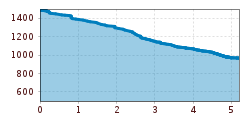
Getting here

  • Arrival by public transport

    Exit bus stop: Pertisau Karwendellift

  • Parking

    Car park of the Karwendel cable car no. 1 or 2 (Karwendel cable car passengers receive a refund at the ticket office.)

More tours in the surrounding area

  • Ötztal Trek Stage 2

    Difficulty:difficult
    Length:10.7 kmDuration:4:00 hElevation uphill:926 m
  • Ötztal Trek Stage 9

    Difficulty:difficult
    Length:12.8 kmDuration:6:00 hElevation uphill:1,623 m
  • Ötztal Trek Stage 10

    Difficulty:difficult
    Length:11.1 kmDuration:4:30 hElevation uphill:1,476 m
  • Ötztal Trek Stage 7

    Difficulty:difficult
    Length:5.3 kmDuration:2:00 hElevation uphill:376 m
  • Ötztal Trek

    Length:246.4 kmDuration:84:25 hElevation uphill:18,910 m
  • Ötztal Trek Stage 16

    Difficulty:difficult
    Length:6.9 kmDuration:2:30 hElevation uphill:358 m
  • Ötztal Trek Stage 19

    Difficulty:difficult
    Length:11.0 kmDuration:5:00 hElevation uphill:1,246 m
  • Ötztal Trek Stage 6

    Difficulty:difficult
    Length:7.6 kmDuration:3:30 hElevation uphill:640 m
  • Ötztal Trek Stage 3

    Difficulty:difficult
    Length:10.4 kmDuration:4:00 hElevation uphill:842 m
  • 3-day hut tour Wilder Kaiser

    Difficulty:difficult
    Length:24.6 kmDuration:14:00 hElevation uphill:2,060 m
  • Ötztal Trek Stage 1

    Difficulty:medium
    Length:18.6 kmDuration:6:30 hElevation uphill:1,561 m
  • Ötztal Trek Stage 17

    Difficulty:difficult
    Length:16.4 kmDuration:6:00 hElevation uphill:1,080 m
  • Ötztal Trek Stage 14

    Difficulty:difficult
    Length:6.3 kmDuration:3:00 hElevation uphill:1,004 m
  • Sunnenseit'n Weg: Round tour

    Difficulty:medium
    Length:8.2 kmDuration:3:00 hElevation uphill:400 m
  • Ötztal Trek Stage 4

    Difficulty:difficult
    Length:8.9 kmDuration:4:00 hElevation uphill:802 m
  • Ötztal Trek Stage 8

    Difficulty:difficult
    Length:9.3 kmDuration:3:30 hElevation uphill:274 m
  • Ötztal Trek Stage 15

    Difficulty:difficult
    Length:6.5 kmDuration:2:30 hElevation uphill:332 m
  • Ötztal Trek Stage 20

    Opening hours:closed
    Difficulty:medium
    Length:6.4 kmDuration:3:00 hElevation uphill:610 m
  • Ötztal Trek Stage 18

    Difficulty:difficult
    Length:9.5 kmDuration:9:30 hElevation uphill:979 m
Newsletter

The mountain is calling? So does our newsletter!

In our monthly newsletter we reveal the best holiday tips for Tyrol.