Singletrail Kals © Miriam Raneburger Gornerwald Trail No. 139Difficulty:difficultLength:2.3 kmDuration:0:30 hGo to biketourGo to biketour: Gornerwald Trail No. 139
hochundheilig-etappe9-kalsamgrossglockner-c-peter-maier.jpg © Peter Maier High and sacred – Stage 09 from Kals to HeiligenblutMore InformationMore Information: High and sacred – Stage 09 from Kals to Heiligenblut
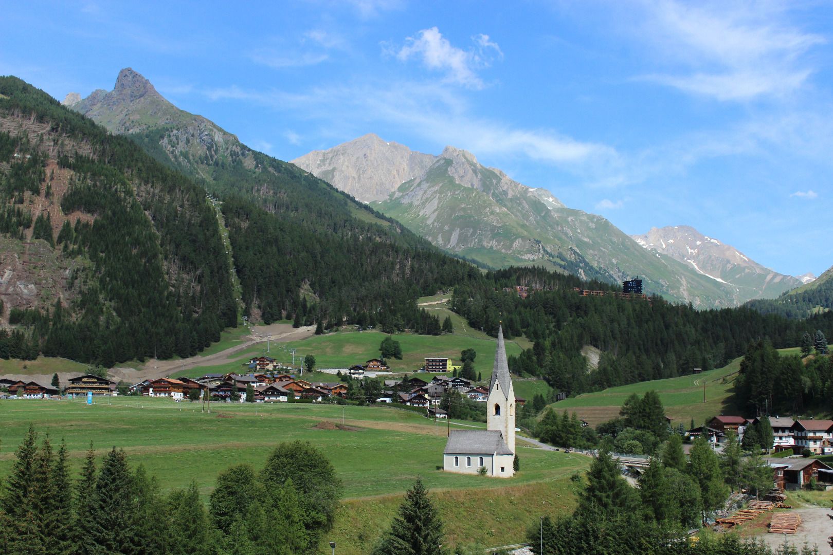
High and sacred – Stage 08 from Obermauern to KalsMore InformationMore Information: High and sacred – Stage 08 from Obermauern to Kals
Adlertrail © bikeboard/Roland Kachelhauser Adlertrail No. 138Difficulty:mediumLength:3.7 kmDuration:0:20 hGo to biketourGo to biketour: Adlertrail No. 138
swiss-track02-c-npht-martin-kurzthaler.jpeg © Nationalpark Hohe Tauern / Martin Kurzthaler Rollitour with Swiss TracDifficulty:easyLength:3.2 kmDuration:1:30 hElevation uphill:135 mSee trailSee trail: Rollitour with Swiss Trac
iseltrail-etappe2-feldner-katarakte-c-ramona-walder.jpg © TVB Osttirol/Waldner Ramona Iseltrail Stage 2More InformationMore Information: Iseltrail Stage 2
Iseltrail - Umbalkees © M. Schickhofer Iseltrail Stage 5More InformationMore Information: Iseltrail Stage 5
Badener Huette © Fabian Pimminger Badener HütteDifficulty:difficultLength:23.2 kmDuration:12:00 hElevation uphill:1,754 mSee trailSee trail: Badener Hütte
glocknerkrone-stuedlhuette-etappe-3-c-peter-maier-903.jpg © Peter Maier / Austria Lucknerhaus - StüdlhütteDifficulty:mediumLength:9.3 kmDuration:4:30 hElevation uphill:862 mSee trailSee trail: Lucknerhaus - Stüdlhütte
aussergschloess_06-19_(c)www.bergpixel.de © Bergpixel Hike to the Berghaus AußergschlössDifficulty:easyLength:5.2 kmDuration:1:45 hElevation uphill:169 mSee trailSee trail: Hike to the Berghaus Außergschlöss
Herbstwanderung_TVB Osttirol_Nationalpark Hohe Tauern Alexander Tempel_Matrei in Osttirol.jpg © www.alexander-tempel.de Hiking tour to St. Pöltner Hütte and 3 lakesDifficulty:difficultLength:14.8 kmDuration:7:40 hElevation uphill:1,119 mSee trailSee trail: Hiking tour to St. Pöltner Hütte and 3 lakes
wandern-blickaufprossegg-c-desiree-dezordo.jpg © Desirèe De Zordo Trail Virgentaler SonnseitenwegDifficulty:mediumLength:41.9 kmDuration:19:00 hElevation uphill:2,641 mSee trailSee trail: Trail Virgentaler Sonnseitenweg
Glocknerkrone_Etappe_1_SudetendeutscheHütte_2023_cPeterMaier-1251.jpg © Peter Maier Hiking tour to Sudetendeutschen Hütte 2.650mDifficulty:mediumLength:15.5 kmDuration:8:15 hElevation uphill:1,203 mSee trailSee trail: Hiking tour to Sudetendeutschen Hütte 2.650m
Gschlöss mit Venedigermassiv_TVB Osttirol_Kurzthaler Martin_Keine Ortsangabe.jpg © TVB Osttirol / Kurzthaler Martin Hike to the Venedigerhaus InnergschlößDifficulty:easyLength:8.6 kmDuration:2:30 hElevation uphill:184 mSee trailSee trail: Hike to the Venedigerhaus Innergschlöß
Neue Reichenbergerhütte_TVB Osttirol_Geyer Johannes_No location given © TVB Osttirol | Johannes Geyer Hike to Neuen Reichenberger HütteDifficulty:mediumLength:18.2 kmDuration:9:00 hElevation uphill:1,252 mSee trailSee trail: Hike to Neuen Reichenberger Hütte
Hoch und Heilig Etappe 7 Virgen Lasörlinghütte_TVB Osttirol_Peter Maier_Virgen in Osttirol.jpg © Peter Maier Hiking tour to Lasörlinghütte 2.350mDifficulty:mediumLength:14.6 kmDuration:7:50 hElevation uphill:1,135 mSee trailSee trail: Hiking tour to Lasörlinghütte 2.350m
Kalser Tauernhaus im Nationalpark Hohe Tauern © NPHT Hannah Assil und Michael Kastl Hike to Kalser TauernhausDifficulty:mediumLength:12.2 kmDuration:4:00 hElevation uphill:244 mSee trailSee trail: Hike to Kalser Tauernhaus
bergerseehütte-herbst23-c-anna-ladstaetter.jpg © Anna Ladstätter Hiking tour to Bergersee Hütte 2.181mDifficulty:mediumLength:10.7 kmDuration:4:30 hElevation uphill:899 mSee trailSee trail: Hiking tour to Bergersee Hütte 2.181m
wanderung-neue-sajathuette-ausblick-c-bernhard-assmair.jpg © Bernhard Aßmair Hiking tour to Neue Sajathütte 2.600mDifficulty:mediumLength:10.3 kmDuration:6:50 hElevation uphill:1,086 mSee trailSee trail: Hiking tour to Neue Sajathütte 2.600m
zupalsee-zupalseehütte-sommer24-c-anna-ladstaetter.jpeg © Anna Ladstätter Hiking tour to Zupalsee Hütte 2.350mDifficulty:mediumLength:14.9 kmDuration:8:30 hElevation uphill:1,261 mSee trailSee trail: Hiking tour to Zupalsee Hütte 2.350m
rotenkogel-sonnenaufgang-c-konrad-klaunzer.JPG © Konrad Klaunzer RotenkogelDifficulty:difficultLength:3.9 kmDuration:3:00 hElevation uphill:383 mSee trailSee trail: Rotenkogel
iseltrail-hangebruecke-mai-2024-c-peter-maier-183_TVB Osttirol_Peter Maier_Virgen in Osttirol.jpg © Peter Maier Circular hike suspension bridge Isel Canyon via "Hohe Bank"Difficulty:mediumLength:8.1 kmDuration:2:50 hElevation uphill:300 mSee trailSee trail: Circular hike suspension bridge Isel Canyon via "Hohe Bank"
wandern-sudetendeutschehuette2-c-desiree-dezordo.jpg © Desirèe De Zordo Glocknerkrone Stage 2More InformationMore Information: Glocknerkrone Stage 2
wanderung-grosser-zunig-zunigsee-c-bernhard-assmair.jpg © Bernhard Aßmair Lasörling altitude trail Stage 1More InformationMore Information: Lasörling altitude trail Stage 1
Give feedback for a chance to win a special holiday experience!Click here for the surveyClick here for the survey


www.bergpixel.de")


