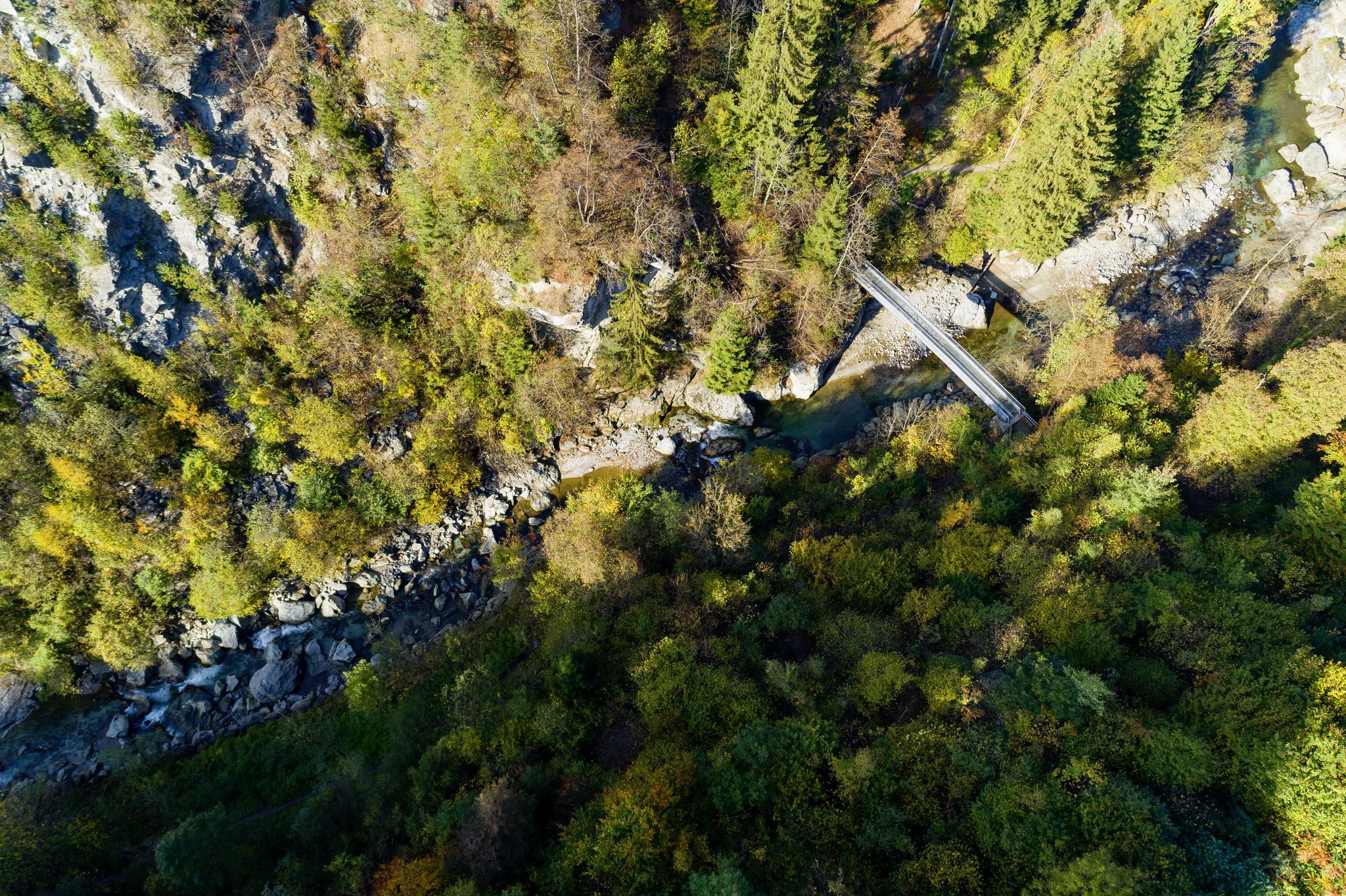
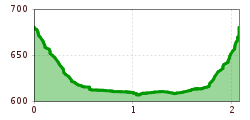
Open interactive mapOpen this POI on the interactive mapElevation profileDetour "Sillschlucht" gorge.gpx
Faltegartenköpfl Difficulty:easyLength:8.8 kmDuration:2:30 hElevation uphill:430 mGo to skitourGo to skitour: Faltegartenköpfl
RosshütteDifficulty:easyLength:4.5 kmDuration:1:30 hElevation uphill:554 mGo to skitourGo to skitour: Rosshütte
Compedal SchihütteDifficulty:easyLength:2.1 kmDuration:1:30 hElevation uphill:390 mGo to skitourGo to skitour: Compedal Schihütte
SattelbergDifficulty:easyLength:3.3 kmDuration:2:30 hElevation uphill:900 mGo to skitourGo to skitour: Sattelberg
Golzentipp über GrippDifficulty:easyLength:3.6 kmDuration:2:45 hElevation uphill:860 mGo to skitourGo to skitour: Golzentipp über Gripp
Ski tour in Seefeld © TVB Seefeld Seefelder Joch Difficulty:mediumLength:5.8 kmDuration:2:30 hElevation uphill:866 mGo to skitourGo to skitour: Seefelder Joch
Astegg-Penken Difficulty:easyLength:7 mDuration:2:00 hElevation uphill:720 mGo to skitourGo to skitour: Astegg-Penken
Singletrail Kals © Miriam Raneburger Gornerwald Trail No. 139Difficulty:difficultLength:2.3 kmDuration:0:30 hGo to biketourGo to biketour: Gornerwald Trail No. 139
High and sacred – Stage 01 from Lavant to St. KorbinianMore InformationMore Information: High and sacred – Stage 01 from Lavant to St. Korbinian
hochundheilig1-etappe3-obertilliach-c-peter-maier.jpg © Peter Maier High and sacred – Stage 03 from Maria Luggau to St. OswaldDifficulty:mediumLength:25.8 kmDuration:7:00 hElevation uphill:1,206 mSee trailSee trail: High and sacred – Stage 03 from Maria Luggau to St. Oswald
High and sacred – Stage 08 from Obermauern to KalsMore InformationMore Information: High and sacred – Stage 08 from Obermauern to Kals
hochundheilig-stage4-hollbruck-c-peter-maier.jpg © Peter Maier High and sacred – Stage 04 from St. Oswald to InnichenMore InformationMore Information: High and sacred – Stage 04 from St. Oswald to Innichen
©-TVB-Tiroler-Oberland-Kaunertal-Daniel-Zangerl-2016-Gepatschhaus-(3).jpg © Daniel Zangerl Rolli-Wanderung GepatschhausLength:8.5 kmDuration:1:45 hElevation uphill:156 mSee trailSee trail: Rolli-Wanderung Gepatschhaus
©-TVB-Tiroler-Oberland-Kaunertal-Daniel-Zangerl-Aifneralm-2016-(19).jpg © Daniel Zangerl Rolli-Wanderung Aifner AlmDifficulty:mediumLength:6.0 kmDuration:2:30 hElevation uphill:460 mSee trailSee trail: Rolli-Wanderung Aifner Alm
©-TVB-Tiroler-Oberland-Kaunertal-Daniel-Zangerl-2016-Nassereinalm-(5).jpg © Daniel Zangerl Rolli-Wanderung NassereinalmDifficulty:mediumLength:5.5 kmDuration:1:45 hElevation uphill:269 mSee trailSee trail: Rolli-Wanderung Nassereinalm
©-TVB-Tiroler-Oberland-Kaunertal-Die-West-Barrierefrei-Langlaufen-1 (3).jpg © Die West GmbH Adaptive cross country skiing circuit Anger at Kaunertal ValleyOpening hours:closedDifficulty:easyLength:1.0 kmElevation uphill:5 m:Style: Skating, ClassicGo to Cross-country skiing trailGo to Cross-country skiing trail: Adaptive cross country skiing circuit Anger at Kaunertal Valley
Kaiserwinkl_Winterurlaub_Langlaufen (12).JPG © www.bernhardbergmann.com Kaiserwinklloipe start Schwendt - No. 1Opening hours:closedDifficulty:difficultLength:27.0 kmDuration:2:30 hElevation uphill:560 m:Style: Skating, ClassicGo to Cross-country skiing trailGo to Cross-country skiing trail: Kaiserwinklloipe start Schwendt - No. 1
©-TVB-Tiroler-Oberland-Kaunertal-Michaela-Gasser-Mark-Handbikebattle-2017-8863.jpg © Michaela Gasser-Mark Handbike Route Kaunertaler GletscherDifficulty:difficultLength:27.5 kmDuration:4:00 hElevation uphill:1,500 mGo to biketourGo to biketour: Handbike Route Kaunertaler Gletscher
Muttereralm - Saile (Nockspitze)Difficulty:difficultLength:7.5 kmDuration:4:00 hElevation uphill:789 mSee trailSee trail: Muttereralm - Saile (Nockspitze)
The Arzler Alm Trail (5007)Difficulty:mediumLength:3.8 kmDuration:0:15 hGo to biketourGo to biketour: The Arzler Alm Trail (5007)
hochundheilig-stage4-hollbruck-c-peter-maier.jpg © Peter Maier High and sacred – an Alpine pilgrim trail through East Tyrol, South Tyrol and Upper CarinthiaDifficulty:mediumLength:191.6 kmDuration:77:45 hElevation uphill:10,475 mSee trailSee trail: High and sacred – an Alpine pilgrim trail through East Tyrol, South Tyrol and Upper Carinthia
Breitegg tourDifficulty:mediumLength:11.0 kmDuration:5:00 hElevation uphill:680 mSee trailSee trail: Breitegg tour
High and sacred – Section 02 from St. Korbinian to Maria LuggauMore InformationMore Information: High and sacred – Section 02 from St. Korbinian to Maria Luggau
High and sacred – Stage 06 from Kalkstein to St. Jakob im DefereggentalMore InformationMore Information: High and sacred – Stage 06 from Kalkstein to St. Jakob im Defereggental
Give feedback for a chance to win a special holiday experience!Click here for the surveyClick here for the survey


.jpg")
.jpg")
.jpg")
.jpg")
.JPG")

.jpg")

.jpg")


