Fendels-Sattelklause

Fendels /
Difficulty ratings: easy
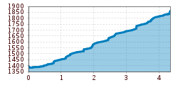
Route length: 4.3 km

Tour information

  • Requirement: easy
  • Length: 4.3 km
  • Elevation uphill:503 hm
  • Elevation downhill:36 hm
Highest point1,860 m

Starting point

Fendels Seilbahnstation

Finishing point

Sattelklause

Features

  • Suitable for families
  • suitable for pushchairs

Trail condition

Gravel road
Source: TVB Tiroler Oberland

Description

From the Fendels cable car station, the trail follows the forest path up to the Sattelklause. The 4.5 km long route can also be used with prams. During the operating hours of the Fendels cable cars, you have the possibility to take the chair lift up and down. There is also the possibility to go down to the valley with mountain carts.

Once you have arrived at the Sattelklause mountain restaurant, you will find a wonderful playground with tree house, Kneipp facilities, a small pond for rafting, trampoline, swings, sand play boxes, and much more...

Weather

Today

clear sky
15°C/4°C
5%0l5 km/h

Wed

light rain
10°C/4°C
65%2l5 km/h

Thu

clear sky
11°C/2°C
0%0l0 km/h
Go to weather forecast

More tours in the surrounding area

  • Sternenweg im Gepatsch

    Difficulty:medium
    Length:4.0 kmDuration:1:30 hElevation uphill:202 m
  • Rolli-Wanderung Aifner Alm

    Difficulty:medium
    Length:6.0 kmDuration:2:30 hElevation uphill:460 m
  • Rolli-Wanderung Nassereinalm

    Difficulty:medium
    Length:5.5 kmDuration:1:45 hElevation uphill:269 m
  • Rolli-Wanderung Gepatschhaus

    Length:8.5 kmDuration:1:45 hElevation uphill:156 m
  • Rolli-Wanderung Falkaunsalm

    Difficulty:medium
    Length:4.5 kmDuration:1:45 hElevation uphill:392 m
  • Handbike Route Kaunertaler Gletscher

    Difficulty:difficult
    Length:27.5 kmDuration:4:00 hElevation uphill:1,500 m
  • Talwanderweg Kaunertal

    Difficulty:easy
    Duration:2:30 hElevation uphill:295 m
  • Kaunerberger Wasserweg

    Opening hours:open
    Difficulty:medium
    Length:15.2 kmDuration:6:00 hElevation uphill:935 m
  • Hohe Aifnerspitze (2.779 m)

    Difficulty:medium
    Length:7.2 kmDuration:5:15 hElevation uphill:815 m
  • Gletscherlehrpfad Gepatschferner

    Difficulty:medium
    Length:8.4 kmDuration:3:45 hElevation uphill:400 m
  • Radurschlklamm Gorge

    Opening hours:open
    Difficulty:medium
    Length:7.5 kmDuration:3:20 hElevation uphill:442 m
  • Rundwanderung Frudiger

    Difficulty:medium
    Length:13.5 kmDuration:4:55 hElevation uphill:588 m
  • Kapelle Maria Schnee

    Difficulty:easy
    Length:1.7 kmDuration:0:30 hElevation uphill:90 m
  • Großer Mutzkopf

    Opening hours:closed
    Difficulty:easy
    Length:10.3 kmDuration:4:00 hElevation uphill:507 m
Newsletter

The mountain is calling? So does our newsletter!

In our monthly newsletter we reveal the best holiday tips for Tyrol.