Mountain hikes Pletzachalm - Schleimssattel - Pletzachalm

Difficulty ratings: medium
Route length: 6.4 km
Duration: 4:00 h

From the car park on the Feilalm forest road to the Schleimssattel at 1,556m – an easy ascent with views of the Karwendel mountains.

Tour information

  • Requirement: medium
  • Length: 6.4 km
  • Duration: 4:00 h
  • Elevation uphill:460 hm
  • Elevation downhill:460 hm
Highest point1,556 m

Starting point

Pertisau, car park Feilalm Forststraße

Finishing point

Pertisau, car park Feilalm Forststraße
  • Fitness level 2 / 6
  • Technique 1 / 6

Best time of year

  • January
  • February
  • March
  • April
  • May
  • June
  • July
  • August
  • September
  • October
  • November
  • December

Trail condition

forest road

Equipment

Sturdy boots (ankle-high hiking boots), weather appropriate clothing. Telescopic hiking poles are recommended.
Source: Achensee Tourismus

Description

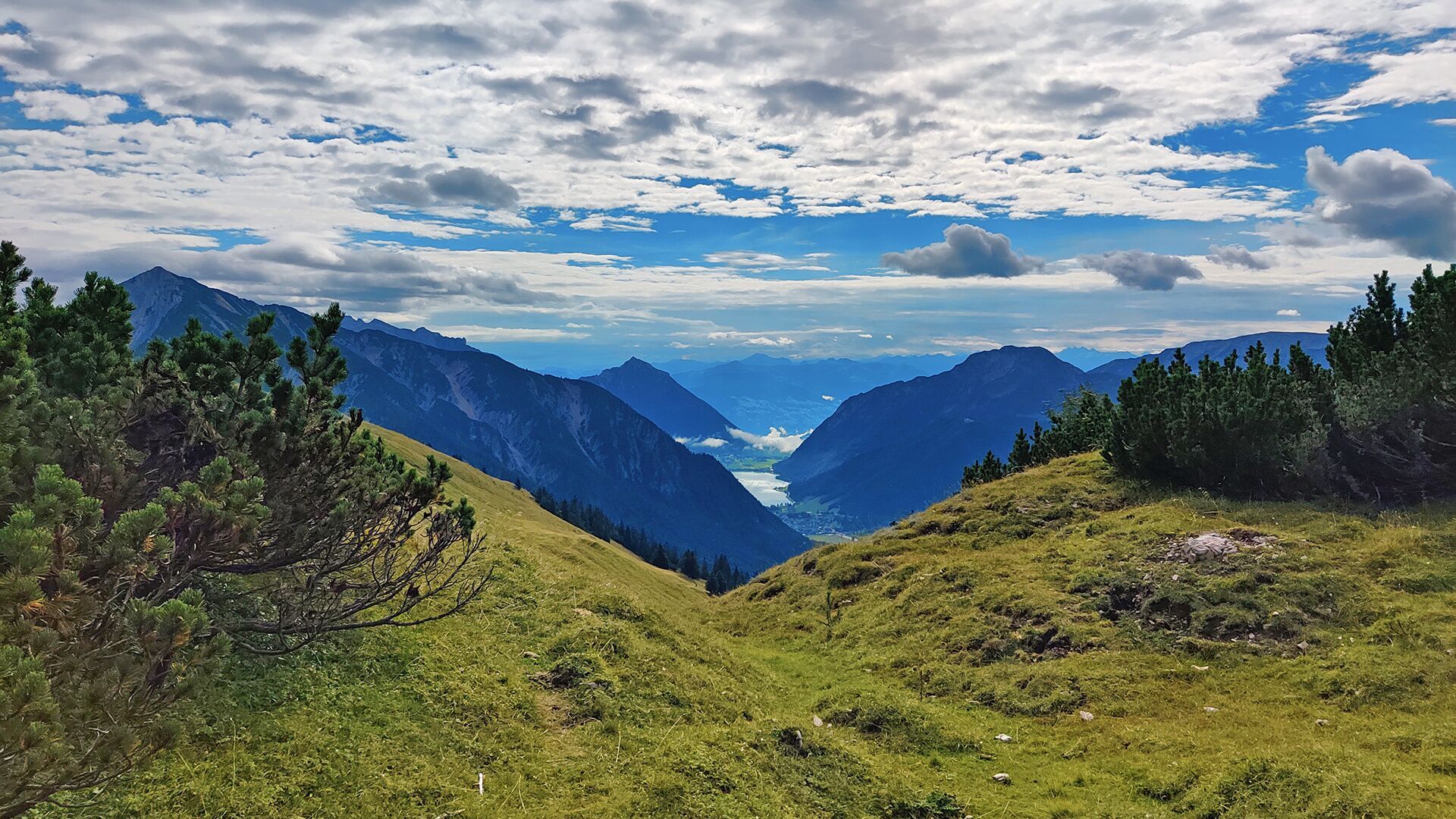
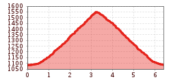
From the car park „Feilalm Forststraße“, follow the yellow signpost (Schleimssattel). Walk across the stream bed and continue along the forest road to the Schleimssattel. The return is via the same route or via the steep trail.

Nearby huts and mountain restaurants

  • Alpengasthaus Pletzachalm

    Opening hours:Open today
    Place: Pertisau am Achensee
    : Restaurant, Alpine pasture / hut / mountain restaurant

Getting here

  • Parking

    Feilalm Forstraße car park

More tours in the surrounding area

  • Wilder-Kaiser-Steig - Detour

    Difficulty: difficult
    Length: 33.0 km Duration: 16:49 h Elevation uphill: 2,311 m
  • Kundler Klamm

    Opening hours: closed
    Difficulty: easy
    Length: 6.4 km Duration: 2:00 h Elevation uphill: 116 m
  • Day 3: 4 days - 4 summits tour

    Difficulty: medium
    Length: 19.3 km Duration: 8:00 h Elevation uphill: 1,371 m
  • Kaiser Gorge - loop trail

    Opening hours: closed
    Difficulty: easy
    Length: 4.2 km Duration: 1:00 h Elevation uphill: 198 m
  • 3-day Family Tour Alpbachtal

    Difficulty: easy
    Length: 18.3 km Duration: 7:00 h Elevation uphill: 998 m
  • Farmkehralm 1.521 m

    Difficulty: medium
    Length: 9.3 km Duration: 3:30 h Elevation uphill: 506 m
  • Wiedersberger Horn Panorama Path

    Difficulty: easy
    Length: 4.1 km Duration: 1:30 h Elevation uphill: 195 m
  • Barrier-free path Lake Reintal

    Difficulty: easy
    Length: 6.5 km Duration: 1:45 h Elevation uphill: 15 m
  • 3-peak-tour Kienberg-Plessenberg-Heuberg

    Difficulty: medium
    Length: 8.6 km Duration: 4:30 h Elevation uphill: 779 m
  • 4 days - 4 summits tour

    Difficulty: medium
    Length: 54.4 km Duration: 23:00 h Elevation uphill: 3,408 m
  • Discovering the Tiefenbach Gorge Hike

    Opening hours: closed
    Difficulty: medium
    Length: 5.7 km Duration: 3:30 h Elevation uphill: 669 m
  • Voldöpper Spitze Loop Hike

    Difficulty: medium
    Length: 12.9 km Duration: 5:00 h Elevation uphill: 988 m
  • Loop tour Juppi Zauberwald

    Difficulty: easy
    Length: 2.5 km Duration: 1:00 h Elevation uphill: 93 m
  • Day 1: 4 days - 4 summits tour

    Difficulty: medium
    Length: 9.8 km Duration: 5:00 h Elevation uphill: 984 m
  • Wheelchair Circular Hike Runst-Achweg

    Difficulty: easy
    Length: 6.3 km Duration: 2:00 h Elevation uphill: 40 m
Newsletter

The mountain is calling? So does our newsletter!

In our monthly newsletter we reveal the best holiday tips for Tyrol.