Ausgangspunkt dieser Wanderung ist das Panoramarestaurant in Hochoetz. Von hier wandert man gemütlich für 2 Km am roten Wandl vorbei, bis nach Balbach.
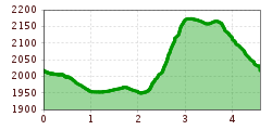
Open interactive mapOpen this POI on the interactive mapElevation profileTour 3 - Die Ausdauernde.gpx
Kühtaile AlmOpening hours:Open todayPlace:Oetz:Restaurant, Alpine pasture / hut / mountain restaurantsee restaurant detailssee restaurant details: Kühtaile Alm
Bielefelder HütteOpening hours:Open todayPlace:Haiming:Restaurant, Alpine pasture / hut / mountain restaurantsee restaurant detailssee restaurant details: Bielefelder Hütte
Faltegartenköpfl peakDifficulty:mediumLength:8.5 kmDuration:4:30 hElevation uphill:509 mSee trailSee trail: Faltegartenköpfl peak
Widiversum in Hochoetz © Unbekannt Panorama Restaurant and WIDIVERSUM HochoetzDifficulty:easyLength:2.8 kmDuration:0:04 hElevation uphill:1,216 mSee trailSee trail: Panorama Restaurant and WIDIVERSUM Hochoetz
Wurzbergalm © Ötztal Winter walk to the Wurzbergalm hut in UmhausenOpening hours:closedDifficulty:easyLength:2.4 kmDuration:1:00 hElevation uphill:199 mGo to winter hikeGo to winter hike: Winter walk to the Wurzbergalm hut in Umhausen
gampe alm_img_25921986 © Katharina Schatz Gampe AlmDifficulty:mediumLength:2.7 kmDuration:2:00 hElevation uphill:623 mSee trailSee trail: Gampe Alm
siegerlandhütte_img_25922026 © Katharina Schatz Siegerlandhütte - SöldenDifficulty:mediumLength:8.0 kmDuration:3:30 hElevation uphill:780 mSee trailSee trail: Siegerlandhütte - Sölden
Stuibenfall Klettersteig - Umhausen-Niederthai © Ötztal / Oetztal / Otztal Via Ferrate Stuibenfall | UmhausenOpening hours:openDifficulty:mediumLength:1.5 kmDuration:4:00 hElevation uphill:162 mSee trailSee trail: Via Ferrate Stuibenfall | Umhausen
rundwanderung stuibenfall umhausen_img_25850868 © Katharina Schatz Loop trail Stuibenfall UmhausenOpening hours:openDifficulty:easyLength:9.2 kmDuration:4:00 hElevation uphill:608 mSee trailSee trail: Loop trail Stuibenfall Umhausen
Schneeschuhwanderung © Bernd Ritschel Circular hiking trail Horlachtal - NiederthaiOpening hours:closedDifficulty:easyLength:6.9 kmDuration:2:00 hElevation uphill:233 mGo to winter hikeGo to winter hike: Circular hiking trail Horlachtal - Niederthai
gampe thaya_img_56646700 © Ötztal Gampe ThayaDifficulty:mediumLength:2.6 kmDuration:1:45 hElevation uphill:623 mSee trailSee trail: Gampe Thaya
Ramolhaus © Roland Grüner Ramolhaus - ObergurglDifficulty:difficultLength:7.8 kmDuration:4:00 hElevation uphill:1,095 mSee trailSee trail: Ramolhaus - Obergurgl
Brizzisee © Roland Grüner BrizziseeDifficulty:mediumLength:9.0 kmDuration:3:30 hElevation uphill:1,057 mSee trailSee trail: Brizzisee
winnebachseehütte - längenfeld/gries_img_25922783 © Katharina Schatz Winnebachseehütte - Längenfeld/GriesDifficulty:mediumLength:4.7 kmDuration:2:00 hElevation uphill:778 mSee trailSee trail: Winnebachseehütte - Längenfeld/Gries
Kristallwasser © Ötztal Tourismus Büro Oetz WIDI Theme Trail - Glück auf! Die spannende Welt der BergmännerDifficulty:easyLength:2.7 kmDuration:1:15 hElevation uphill:110 mSee trailSee trail: WIDI Theme Trail - Glück auf! Die spannende Welt der Bergmänner
wilder mann_img_25851185 © Katharina Schatz Wilder MannDifficulty:mediumLength:7.0 kmDuration:2:30 hElevation uphill:665 mSee trailSee trail: Wilder Mann
Fundusfeiler © Ötztal Fundusfeiler - UmhausenDifficulty:difficultLength:4.5 kmDuration:3:00 hElevation uphill:1,109 mSee trailSee trail: Fundusfeiler - Umhausen
Nedersee © Roland Grüner Seenplatte - Lake Nedersee - ObergurglDifficulty:mediumLength:9.6 kmDuration:5:00 hElevation uphill:740 mSee trailSee trail: Seenplatte - Lake Nedersee - Obergurgl
Stuibenfall - Tirols größter Wasserfall © Ötztal Stuibenfall hike - UmhausenOpening hours:openDifficulty:easyLength:2.9 kmDuration:1:45 hElevation uphill:456 mSee trailSee trail: Stuibenfall hike - Umhausen
gipfeltour rosskopf_img_39972994 © Ötztal Tourismus Büro Oetz Mountain peak RosskopfDifficulty:mediumLength:2.0 kmDuration:2:00 hElevation uphill:379 mSee trailSee trail: Mountain peak Rosskopf
Wandern © Bernd Ritschel Narrenkogel - NiederthaiDifficulty:mediumLength:2.9 kmDuration:2:00 hElevation uphill:764 mSee trailSee trail: Narrenkogel - Niederthai
Similaunhütte © Roland Grüner Vent - Similaunhütte - Ötzi-FundstelleDifficulty:mediumLength:14.9 kmDuration:6:00 hElevation uphill:1,397 mSee trailSee trail: Vent - Similaunhütte - Ötzi-Fundstelle
Hängebrücke Längenfeld © Katharina Schatz Water Walk Brand-Burgstein LängenfeldDifficulty:mediumLength:6.7 kmDuration:2:30 hElevation uphill:396 mSee trailSee trail: Water Walk Brand-Burgstein Längenfeld
Vent © Roland Grüner MutsbühlDifficulty:mediumLength:4.5 kmDuration:1:30 hElevation uphill:470 mSee trailSee trail: Mutsbühl
gurgl_Strecke - Glacier Trailrun_7_23(legacyLarge) © Ötztal Tourismus Piccard bridge loop hike - ObergurglOpening hours:closedDifficulty:difficultLength:18.2 kmDuration:8:00 hElevation uphill:1,111 mSee trailSee trail: Piccard bridge loop hike - Obergurgl
Lehner Wasserfall © Ötztal Tourismus Büro Längenfeld Lehner Wasserfall - Kraftquell LängenfeldOpening hours:closedDifficulty:easyLength:540 mDuration:0:25 hElevation uphill:239 mSee trailSee trail: Lehner Wasserfall - Kraftquell Längenfeld
hochstubaihütte über seekarsee & himmelsleiter - sölden_img_56888636 © Ötztal Hochstubaihütte über Seekarsee & Himmelsleiter - SöldenDifficulty:difficultLength:4.8 kmDuration:4:00 hElevation uphill:1,270 mSee trailSee trail: Hochstubaihütte über Seekarsee & Himmelsleiter - Sölden
Give feedback for a chance to win a special holiday experience!Click here for the surveyClick here for the survey


")


