
Opening hours:Open today
Place:Dölsach
:Alpine pasture / hut / mountain restaurant
Zietenkopf
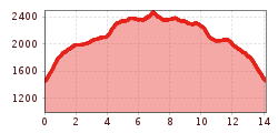
The ascent begins at the Zwischenbergen Sattel car park and proceeds via the well signposted path No. 318, which to begin with is initially somewhat steeper and after around 10 minutes becomes flatter, continuing to the covered ‘Lugenbankl’ and above Eder Almhütte. After a steeper pasture and a few steps, you cross the road. The route proceeds through lovely larch forest via the Alpine meadows to Anna Quell, where you can enjoy a break. Continue past a few Alpine lodges until you come to the Anna bothy. Once at the Anna bothy, follow the information boards and bear right. (Refreshment stop option). After around 500m bearing left, the route is flat initially, then climbs slightly and you come upon direction signs again. From here, keep to route No.318. Now cross the slope on the south side of the Lones Kopf, until the path heads steeply upwards into a wind gap (direction signs).
Descent: From the summit, proceed to the wind gap again. Continue to the summit of the Lones, which you go right across, continuing down to the Ederplan summit. The route then descends slightly to the Anna bothy. From here it is a leisurely walk on the familiar ascent route back to the car park.
Parkplatz Zwischenberger Sattel
")
.jpg")
.jpg")
.jpg")


")


.jpg")
.jpg")


")

.jpg")


.jpg")


